Heat Humidity Severe Weather Risk Wednesday Late Week Weekend Looking Dicey

Weather in 5/Joe & Joe Weather Show Latest Podcast
Heat Humidity Severe Weather Risk Wednesday Late Week Weekend Looking Dicey
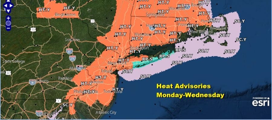
The next 3 days are all about the heat and the humidity. High pressure surface and aloft extends from the Northern Mid Atlantic eastward to north of Bermuda. It is a perfect set up for highs in the low to mid 90s this afternoon with sunshine and little if any chance for a pop up shower or thunderstorm.

Mostly cloud free conditions cover the Eastern US with the exception of Northeastern New England. Also there is a small low off the South Carolina/Georgia coast this morning that is moving westward over the gulf stream today. There is a chance this system could quickly organize into a tropical depression or even a tropical storm before landfall but the window of opportunity for development is a short one since the system is moving so quickly. Otherwise the tropics are mostly quiet.
SATELLITE

Moving along this week we have two more hot humid days after today which will essential produce the same outcomes. Tuesday highs will again be in the low to mid 90s. We will have plenty of sun and very little chance of anything other than an isolated pop up shower or thunderstorm.

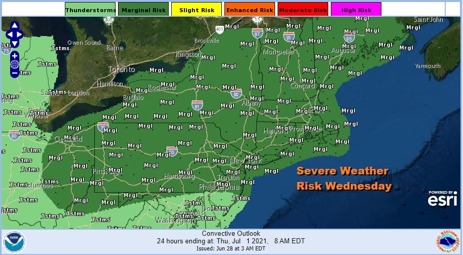
Wednesday will be the last day of hot and humid weather as an upper trough and cold front approach. Highs again will be in the low to mid 90s. Showers and thunderstorms will be more numerous Wednesday evening and the Storm Prediction Center is indicating a marginal risk for severe weather.
While the upper trough moves by the front gets left behind and stalls right along the coast. It will have to wait for a stronger system dropping into the Great Lakes to push out but the problem is that the system seems to want to drop south more than it wants to move to the east.

Thursday highs will be in the 80s with high humidity so at least the more extreme heat backs off. The slow moving front likely triggers off thunderstorms late Thursday. Being left with a southwest flow means the front cant push further south against it. A series of waves will bring more chances for downpours Friday with temperatures in the upper 70s and lower 80s.

It doesnt’ get better for Saturday and Sunday with this upper air system to the west not going anywhere and the flow along the East Coast actually getting even wetter with a south southwest wind aloft continuing to feed in Atlantic moisture. This is not written in stone yet. This type of scenario is highly unusual and other models show a less ominous view on the holiday weekend. If this system is weaker and flatter it could push out offshore on Sunday allowing for some improvement. At the moment however things do look dicey for Friday and Saturday for sure. It will however not be like Memorial Day weekend from the standpoint of being raw with temperatures in the 50s. Instead it will be very humid and uncomfortable with temperatures in the upper 70s and lower 80s. Should this verify it will not rain straight through. There will be breaks between waves of downpours. I still wouldn’t rule out a more optimistic outcome at least at this early stage.

BE SURE TO DOWNLOAD THE FREE METEOROLOGIST JOE CIOFFI WEATHER APP &
ANGRY BEN’S FREE WEATHER APP “THE ANGRY WEATHERMAN!
MANY THANKS TO TROPICAL TIDBITS FOR THE USE OF MAPS
Please note that with regards to any severe weather, tropical storms, or hurricanes, should a storm be threatening, please consult your local National Weather Service office or your local government officials about what action you should be taking to protect life and property.


