Heat Humidity Into Tuesday Widespread Severe Weather Risk Tuesday Virginia to Maine
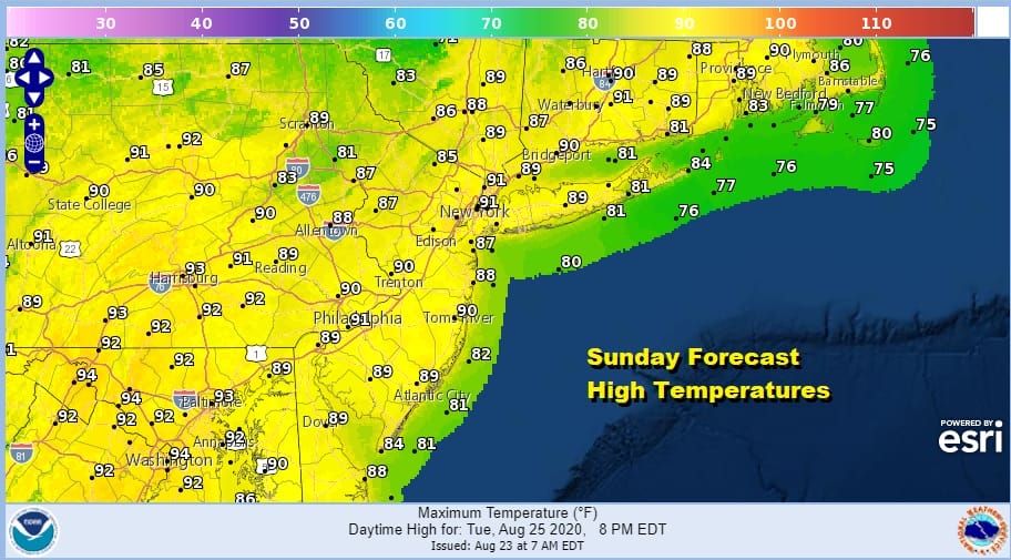
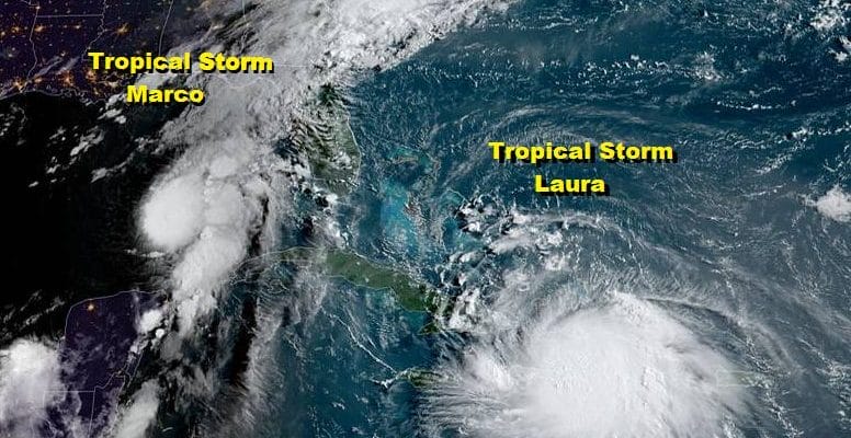
It is a second day of heat and humidity with sunshine forecast today. The sun will be filtered by some high level moisture that extends southward all the way into the Gulf of Mexico where Tropical Storm Marco sits. Marco continues moving northwest toward the Central Gulf Coast and will likely become a hurricane later today. Tropical Storm Laura is producing flooding rains and it is moving westward from Hispaniola to Cuba and eventually into the Gulf. Neither storm looks to have impact here at all even after landfall. We will discuss the issues and specifics with these two storms later today. In the meantime we see highs today reaching the upper 80s to some lower 90s.
SATELLITE

REGIONAL RADAR

The high humidity and the tropical air means some scattered thunderstorms pop up yesterday and we could see some pop up this afternoon and evening so keep an eye on the radar. Most of you won’t see a shower or thunderstorm but it is hard to say exactly where these storms are going to pop up.
LOCAL RADAR NEW YORK CITY

LOCAL RADAR PHILADELPHIA


Once the evening passes storms disappear and we remain very warm and humid overnight. Lows will be in the upper 60s to mid 70s. Monday is basically wash rinse repeat with some sunshine and the chance for scattered afternoon thunderstorms. Highs will be in the upper 80s to lower 90s.
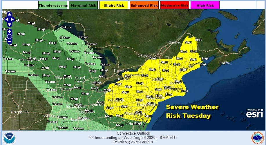
Tuesday brings a cold front and a rather strong one at that. The Storm Prediction Center posted the risk areas in their forecast yesterday which is unusual. When they talk about severe weather 4 days out it usually means the situation is a potent one. Widespread risk is indicated Tuesday from Virginia to Maine which lies in the slight risk zone. This means there is a 15% chance of severe weather within 25 miles of any point in that risk zone.

The GFS model loop above shows the strong cold front coming through Tuesday evening. The isobars show that “V” shape and that tells us the cold front has punch. It is coming in from the northwest so there will be no marine layer issues ahead of it. Expect some strong thunderstorms as the front goes by Tuesday. Highs will be in the 80s to near 90. Behind the front we get a two day break in the humidity Wednesday and Thursday. Another stronger front arrives for later Friday and Saturday.
Tropical Storm Marco Aims for Southeast Louisiana, Laura heads west to Cuba
8AM EST LOCATION…24.2N 87.1W
ABOUT 210 MI…340 KM NW OF THE WESTERN TIP OF CUBA
ABOUT 360 MI…580 KM SSE OF THE MOUTH OF THE MISSISSIPPI RIVER
MAXIMUM SUSTAINED WINDS…70 MPH…110 KM/H
PRESENT MOVEMENT…NNW OR 335 DEGREES AT 13 MPH…20 KM/H
MINIMUM CENTRAL PRESSURE…993 MB…29.32 INCHES

Tropical Storm Marco this morning is moving north northwestward and it could become a hurricane later today. A Storm Surge Warning is in effect for Morgan City Louisiana to Ocean Springs Mississippi Lake Borgne, A Hurricane Warning is in effect for Morgan City Louisiana to the Mouth of the Pearl River. Storm Surge Watch is in effect for Sabine Pass to Morgan City Louisiana, Ocean Springs to the Alabama/Florida border, Lake Pontchartrain, Lake Maurepas, and Mobile Bay, A Hurricane Watch is in effect for…
* Intracoastal City Louisiana to west of Morgan City, Lake Pontchartrain, Lake Maurepas, and Metropolitan New Orleans, A Tropical Storm Warning is in effect for Mouth of the Pearl River to the Mississippi/Alabama border Lake Pontchartrain, Lake Maurepas, and Metropolitan New Orleans. A Tropical Storm Watch is in effect for Mississippi/Alabama border to the Alabama/Florida border. Marco is forecast to make landfall later Monday afternoon in Southeast Louisiana.
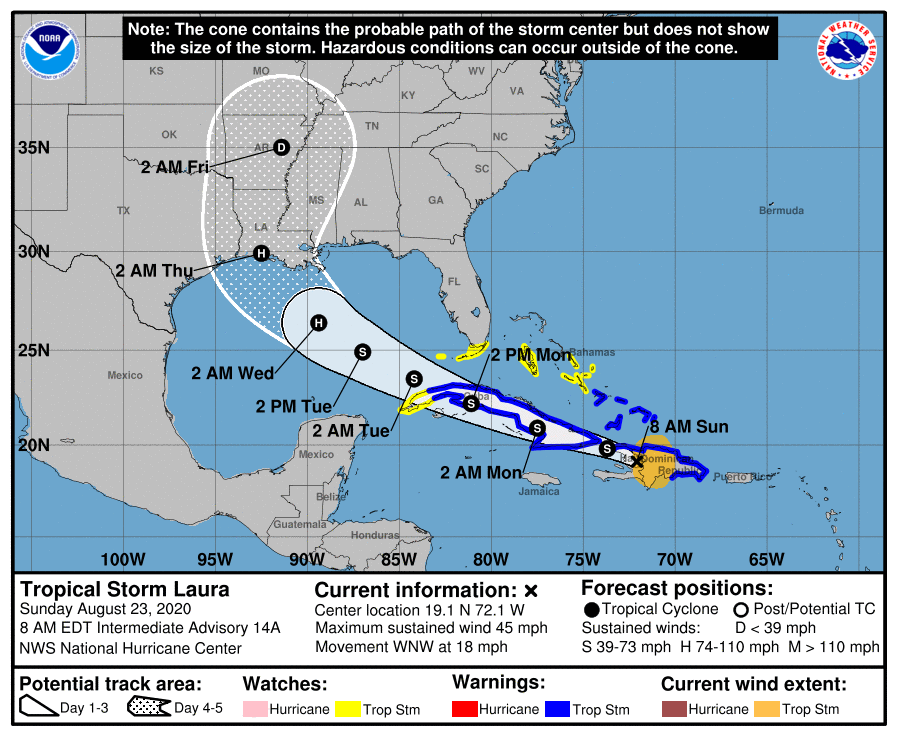
Tropical Storm Laura meanwhile is moving west northwestward as it exits the Dominican Republic and now is going to being moving across the entire island of Cuba. Heavy rains continue to be the main issue with this storm for now however once it gets into the Gulf of Mexico, Laura could strengthen quickly into a hurricane.
8AM EST LOCATION…19.1N 72.1W
ABOUT 40 MI…65 KM NNE OF PORT AU PRINCE HAITI
ABOUT 50 MI…80 KM S OF CAP HAITIEN HAITI
MAXIMUM SUSTAINED WINDS…45 MPH…75 KM/H
PRESENT MOVEMENT…WNW OR 285 DEGREES AT 18 MPH…30 KM/H
MINIMUM CENTRAL PRESSURE…1005 MB…29.68 INCHES
Tropical Storm Warnings are in effect for all of Cuba except the westernmost part of the island where a tropical storm watch is effect there. Watches continue for the Southern Bahamas and the Florida keys. Laura will follow Marco into the Central Gulf Coast Wednesday afternoon if the present motion and speed continues.
BE SURE TO DOWNLOAD THE FREE METEOROLOGIST JOE CIOFFI WEATHER APP &
ANGRY BEN’S FREE WEATHER APP “THE ANGRY WEATHERMAN!
MANY THANKS TO TROPICAL TIDBITS FOR THE USE OF MAPS
Please note that with regards to any severe weather, tropical storms, or hurricanes, should a storm be threatening, please consult your local National Weather Service office or your local government officials about what action you should be taking to protect life and property.


