Heat Humidity Arrive Today Hot Humid Friday With Late Thunderstorms
Weekend Outlook
Temperatures and humidity will continue to move higher today. South to southwest winds along with a good deal of sunshine will take temperatures well into the 80s to around or just over 90 degrees in some places. The wind off the ocean will keep coastal locations in New Jersey, Long Island and Southern New England a bit cooler. Radars remain nice and quiet today and no thunderstorms are forecast. Tonight will be very warm and humid with lows in the upper 60s to mid 70s from inland to warmer urban centers.
SATELLITE WITH LIGHTNING STRIKES
WEATHER RADAR
Friday is going to be very hot and very humid. Dew points will rise to the low and mid 70s. Sunshine will take highs to the middle and upper 90s. I would not be surprised to see some record highs broken. The beaches will be hot as well as sea breezes are going to have a tough time developing thanks to a mostly west wind.
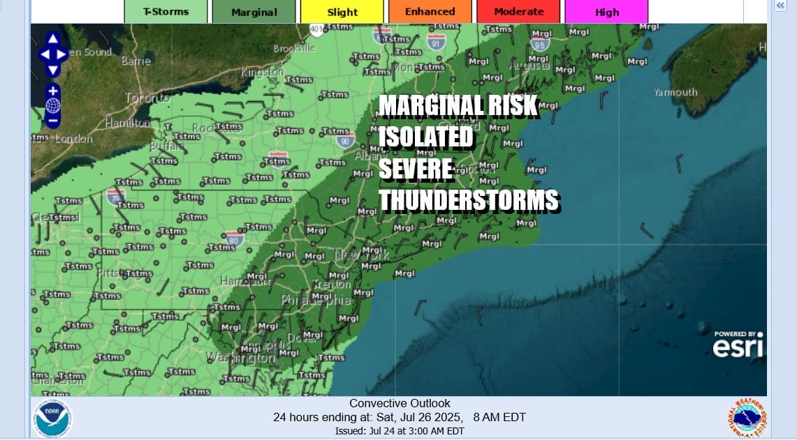
There are going to be weather systems moving our way however and Friday we have a cold front that will press in during the afternoon and evening. This is likely to set off thunderstorms especially inland. The Storm Prediction Center indicating a large area of marginal risk for isolated severe thunderstorms. The area extends from the Northern Virginia Maryland and Delaware northward through most of New England and Upstate New York.
A weather front passes Friday night taking showers and thunderstorms out to the east. Saturday we will see lower temperatures due to winds turning to the southeast. We are looking for a mix of sun and clouds. Humidity levels will be high but they will be down a touch from Friday. High temperatures Saturday will be mostly in the mid to upper 80s with cooler readings at the coast.
There is the outside chance for an isolated thunderstorm Saturday in areas well inland but for the vast majority of you, there are no issues from storms Saturday but that does change Sunday. Another weather front will approach and this front is likely to set off showers and thunderstorms to develop especially during the afternoon and evening hours.
There will likely be severe weather risk Sunday though the level of that risk is uncertain at this stage. Once that front passes we will see some improvement into Monday but it will still remain very warm and humid and there is the risk for additional thunderstorm activity for the first part of next week.
BE SURE TO DOWNLOAD THE FREE METEOROLOGIST JOE CIOFFI WEATHER APP &
ANGRY BEN’S FREE WEATHER APP “THE ANGRY WEATHERMAN!
MANY THANKS TO TROPICAL TIDBITS FOR THE USE OF MAPS
Please note that with regards to any severe weather, tropical storms, or hurricanes, should a storm be threatening, please consult your local National Weather Service office or your local government officials about what action you should be taking to protect life and property.