DOWNLOAD MY NEW FREE JOESTRADAMUS WEATHER APP FOR ANDROID
THE APP IS ABSOLUTELY FREE TO ALL BUT CONSIDERING SUBSCRIBING TO PATREON FOR A WEATHER EXPERIENCE FREE OF ADS, EXCLUSIVE VIDEOS FOR MEMBERS ONLY AND MUCH MORE…STARTS AT $2 A MONTH..MESSAGE ME AT ANY TIME
Hat Hair Weather Gives Way to Bad Hair Weather
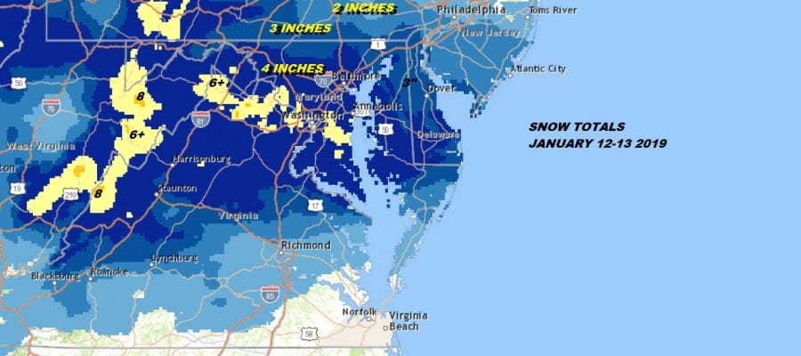
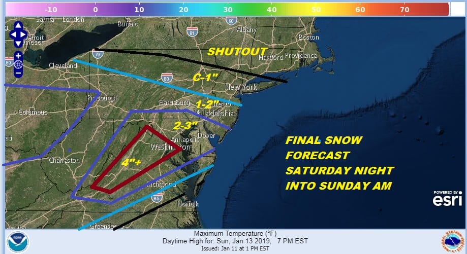
The weekend storm to the south brought 6 to 8 inches of snow across the Washington DC Baltimore area wound up bringing an inch of snow up to about Route 195 in New Jersey before it came to a grinding halt. There were no shifts north this time, nor any shifts south over the weekend. It did what it did when it was supposed to do it.

I always like to look at my final call forecast and stack it up to reality to see how i did. It really turned out to be an okay call all the way around though the numbers could have been juiced up a bit across Virginia. 4 to 6 worked out okay I think. I probably should have nudged the 4 inch area into Delaware, the northern edge of a coating was about as good as you can get it. Overall I would say a B+ but will give others a chance to weigh in.
Now it is on to the next few days which will be quiet for the most part. The storm to the southeast is still creating some fuss along coastal areas this morning with clouds and bit of wind but on the whole it is a decent start to the day though these are both bad hair weather and hat hair weather conditions. We should see some sunshine today with highs just in the 30s. The satellite loop shows the clouds offshore moving away to the east slowly but surely. We have no weather issues on the regional and local radars for today through Wednesday.
EASTERN SATELLITE

REGIONAL RADAR

Look for cold and clear conditions tonight with lows in the 20s. Tuesday and Wednesday will be no worse than partly sunny with highs reaching into the 40s. We have a cold front arriving on Wednesday with another high to the north. That sets the table for weather system number one which approaches on Thursday with sunshine giving way to arriving clouds and highs into the 30s.
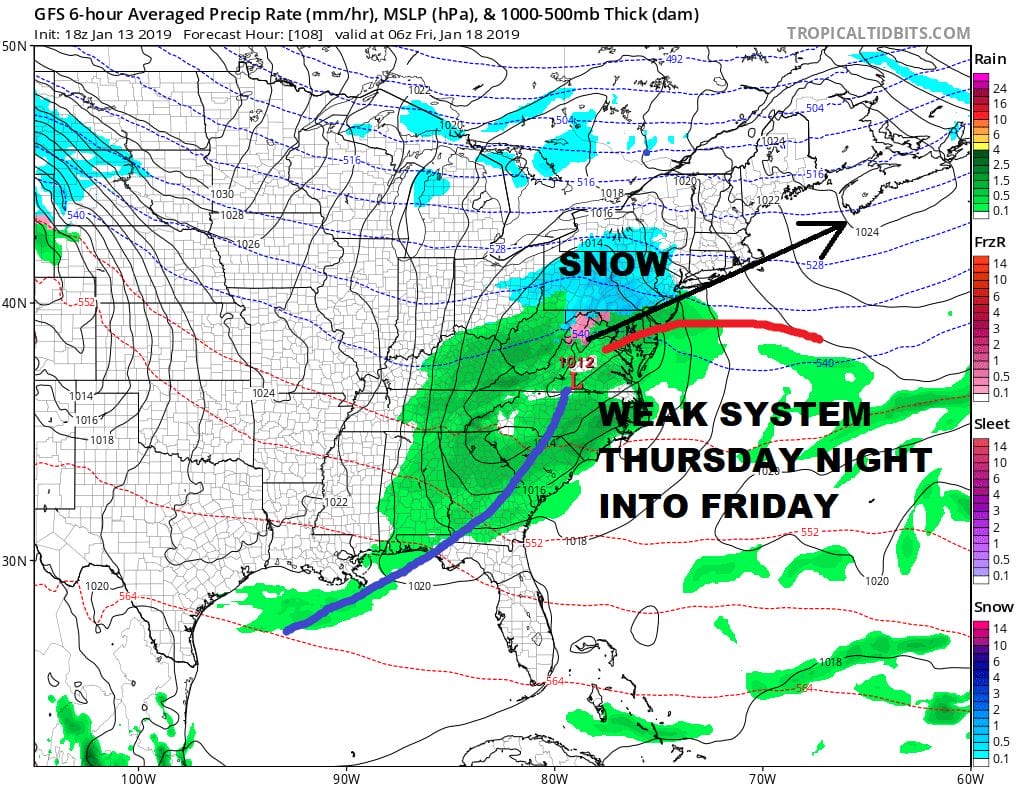
We are going to start the ball rolling with system number 1 for this week which will be the weaker of the two. Cold air from a high to the north will build in Thursday and then grudgingly give way Thursday night as moisture nears. This looks like it could some accumulating snows which of course will depend on the extent of cold air and how long it lasts. Inland areas might actually hold on to the cold for much of this and models are producing up to a half inch of liquid with this. Right now if I had to throw some numbers up into the air I would think along the coast an inch or two is possible with 2 to maybe 3 or 4 as you go inland.
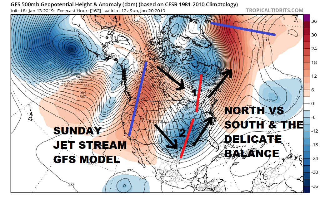
The weekend system is the stronger of the two and continues to be impressive on weather models. Regarding outcome it is going to produce some big snows for areas across the Northeast. The where will hinge on the delicate balance of the two jet streams. Will the north outrun the south and force cold air southward (mostly snow event for the coast) or does it take longer and allow the south to dominate (rain to ice and snow at the end)..or something somewhere in the between? The more suppressed idea would match up with how storms have behaved recently and I’m always a fan of the trend being your friend. We are going to continue to see weather models nip and tuck back and forth but it really boils down to the northern stream and when it gets the cold air back in here over the weekend.
First things first will be Thursday night into Friday morning and I might have an early call on that later today.
MANY THANKS TO TROPICAL TIDBITS FOR THE USE OF MAPS
Please note that with regards to any tropical storms or hurricanes, should a storm be threatening, please consult your local National Weather Service office or your local government officials about what action you should be taking to protect life and property.


