
Harvey Remnants Moving Toward Southwest Gulf of Mexico
Harvey Remnants Moving Toward Southwest Gulf of Mexico
Tropical Storm Harvey which weakened over the weekend to an open tropical wave (no circulation) continues on its merry way toward the west northwest and is now in the Northwest Caribbean. So far Harvey has not reorganized much but remains intact as a relevant system. Conditions in the NW Caribbean usually are conducive for development but it may be a question of time and space here since this will be moving over the Yucatan before too long. Still some development is possible before it moves inland.

Once it crosses the Yucatan it will emerge into the Southwest Gulf of Mexico where conditions are favorable for strengthening. By then there may be a weakness in the ridge to the north, or at least enough of a weakness to turn Harvey northwestward.
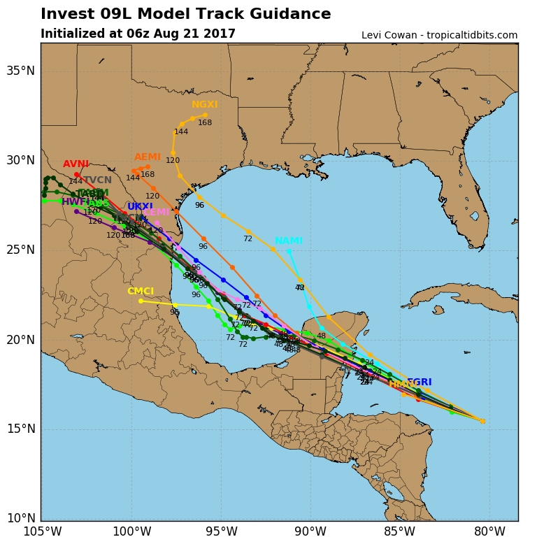
Hurricane model track guidance as well as all the global models have tracks further northwest into Northeast Mexico or even into the South coast of Texas. Model trends have been further north but it has to develop first and there are some issues.

It seems that the remnant wave of Harvey is moving westward and so is a strong upper low that you can see on the water vapor loop. That upper low is forecast to weaken and move into Northeast Texas in a few days which does create a more favorable environment for strengthening. For the moment however it is creating some issues impeding development.

In the tropical Atlantic another large upper low dominates the South Atlantic which is creating hostile conditions again across the Atlantic Basin. A tropical wave is no approaching the Western Bahamas with clouds and showers. This system may have a shot for development after the next cold front drops southward to off the Southeast coast of the US later this week.
MANY THANKS TO TROPICAL TIDBITS FOR THE WONDERFUL USE OF THE MAPS
Weather App

Don’t be without Meteorologist Joe Cioffi’s weather app. It is really a meteorologist app because you get my forecasts and my analysis and not some automated computer generated forecast based on the GFS model. This is why your app forecast changes every 6 hours. It is model driven with no human input at all. It gives you an icon, a temperature and no insight whatsoever.
It is a complete weather app to suit your forecast needs. All the weather information you need is right on your phone. Android or I-phone, use it to keep track of all the latest weather information and forecasts. This weather app is also free of advertising so you don’t have to worry about security issues with your device. An accurate forecast and no worries that your device is being compromised.
Use it in conjunction with my website and my facebook and twitter and you have complete weather coverage of all the latest weather and the long range outlook. The website has been redone and upgraded. Its easy to use and everything is archived so you can see how well Joe does or doesn’t do when it comes to forecasts and outlooks.
Just click on the google play button or the apple store button on the sidebar for my app which is on My Weather Concierge. Download the app for free. Subscribe to my forecasts on an ad free environment for just 99 cents a month.
Get my forecasts in the palm of your hand for less than the cost of a cup of Joe!