
Harvey Moving Northwest Development Expected Soon
Harvey Moving Northwest Development Expected Soon
Satellite loops show the remnant wave of Harvey is now beginning to move into the Gulf of Mexico. A weak low level circulation is evident right along the the northwest coast of the Yucatan Peninsula. Once the center is in the Gulf of Mexico and the circulation moves far enough from land, organization and strengthening should get underway and tropical depression or tropical storm could occur Wednesday.

Weather model guidance all suggest a northwest track toward the Texas coast with models varying in strength with regards to wind. The European shows a tropical storm moving inland near or just north of Corpus Christi and then moving inland and stalling out with the track reversing back into the Gulf of Mexico. The GFS is similar with the stalling and reversing idea though it does it a bit further north.
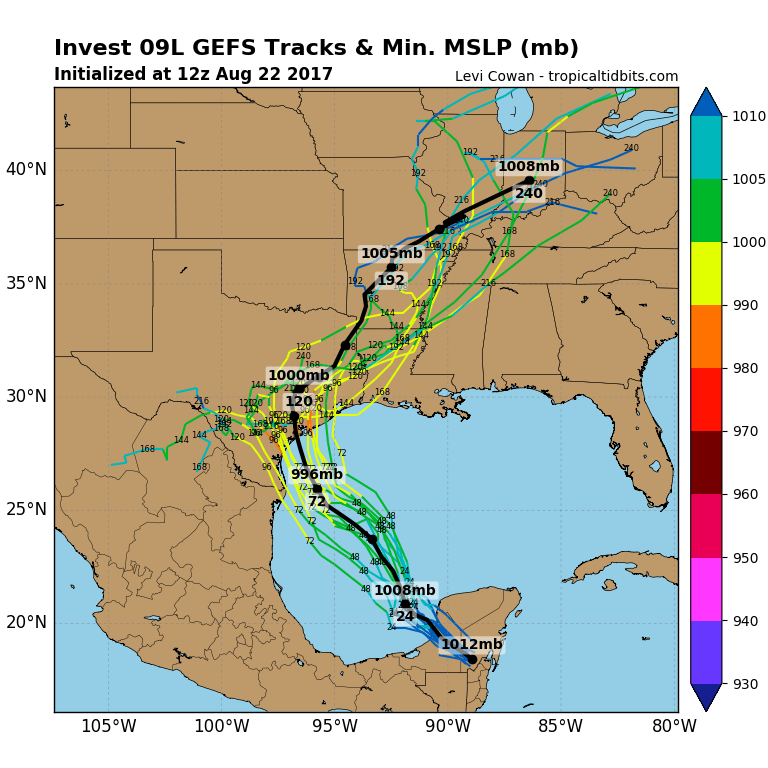
While models may differ on the specifics they all pretty much are locked on the idea that Harvey in whatever form it is in will be a very slow mover. This is going to make rain a big deal for South & Southeast Texas and some very heavy rains over a periods of several days or more are possible creating some serious flooding potential here. The GFS model adds the fact that Harvey could strengthen to a category 1 or 2 hurricane before landfall. The National Hurricane Center in its most recent updated is already alerting residents along the Texas coast of this possibility. Steering currents in the upper atmosphere are forecast to collapse which would lend to the ideal of either slowing to a crawl or temporarily stalling out.
The GFS model is showing rainfall potential of over a foot of rain across the Western Gulf Coast from SW Louisiana through most of Southeast and South Texas. This is certainly not an unreasonable forecast given the upper air dynamics.

The rest of the tropics for now are quiet though the tropical wave in the Bahamas will persist for the next several days. Conditions could become conducive for development late this week or this weekend as most weather models are bullish on something forming just east of the Florida coast. The cold front moving through our area now will stall just off the Southeast coast of the US which makes this all the more complex.
MANY THANKS TO TROPICAL TIDBITS FOR THE WONDERFUL USE OF THE MAPS
Weather App

Don’t be without Meteorologist Joe Cioffi’s weather app. It is really a meteorologist app because you get my forecasts and my analysis and not some automated computer generated forecast based on the GFS model. This is why your app forecast changes every 6 hours. It is model driven with no human input at all. It gives you an icon, a temperature and no insight whatsoever.
It is a complete weather app to suit your forecast needs. All the weather information you need is right on your phone. Android or I-phone, use it to keep track of all the latest weather information and forecasts. This weather app is also free of advertising so you don’t have to worry about security issues with your device. An accurate forecast and no worries that your device is being compromised.
Use it in conjunction with my website and my facebook and twitter and you have complete weather coverage of all the latest weather and the long range outlook. The website has been redone and upgraded. Its easy to use and everything is archived so you can see how well Joe does or doesn’t do when it comes to forecasts and outlooks.
Just click on the google play button or the apple store button on the sidebar for my app which is on My Weather Concierge. Download the app for free. Subscribe to my forecasts on an ad free environment for just 99 cents a month.
Get my forecasts in the palm of your hand for less than the cost of a cup of Joe!