Good Looking Sunday Pop Up Storms
Video is from late last night..Sunday & Monday Outlook
[brid video=”54975″ player=”6390″ title=”sunday”]
Good Looking Sunday Pop Up Storms
Very Warm Temperatures
Yesterday’s coastal disturbance that produced downpours and thunderstorms over Central and Southern New Jersey (with much less elsehwhere) is now moving away to the northeast. Satellite loop this morning shows clear skies for the most part behind it. It should be a partly to mostly sunny Sunday with temperatures in the very warm upper 80s to lower 90s though it should be a few degrees cooler at the shore. Later this afternoon and evening some widely scattered pop up thunderstorms will develop but for the most part there are no issues today or tonight.

Radars are showing the last of the showers from overnight moving away to the northeast with some activity in Northern New England which of course is no issue for us.


Good Looking Sunday Pop Up Storms
Monday & Tuesday Outlook
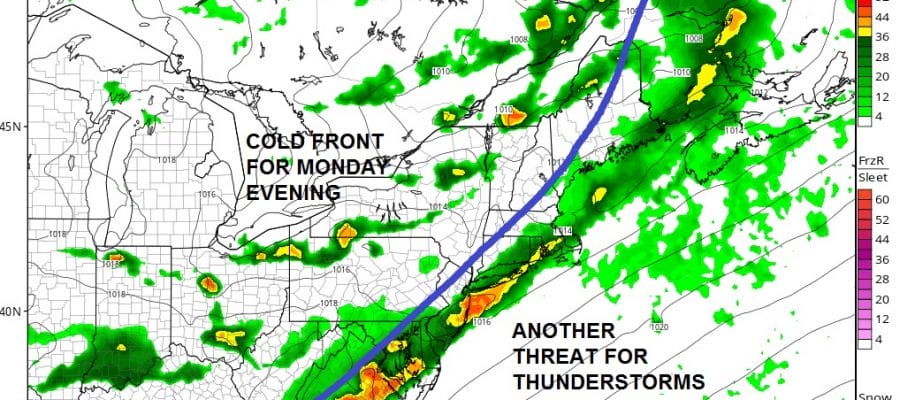
Monday we will see a cold front approaching which means very warm to hot conditions with higher humidity and the chance for evening thunderstorms. Highs will reach the 90s Monday in many areas. Thunderstorms will come in the evening.
NAM Model Monday Evening 8pm

It is hard to say how they hold together this time around as always with models going in all different directions again. We will address this issue later today. Once the front passes a nice shot of dry air comes in for a couple of days with sunshine Tuesday and Wednesday with low humidity and highs mostly in the 80s.
FiOS1 News Weather Forecast For Long Island
FiOS1 News Weather Forecast For New Jersey
FiOS1 News Weather Forecast For Hudson Valley
NATIONAL WEATHER SERVICE SNOW FORECASTS
LATEST JOESTRADAMUS ON THE LONG RANGE
Weather App

Don’t be without Meteorologist Joe Cioffi’s weather app. It is really a meteorologist app because you get my forecasts and my analysis and not some automated computer generated forecast based on the GFS model. This is why your app forecast changes every 6 hours. It is model driven with no human input at all. It gives you an icon, a temperature and no insight whatsoever.
It is a complete weather app to suit your forecast needs. All the weather information you need is right on your phone. Android or I-phone, use it to keep track of all the latest weather information and forecasts. This weather app is also free of advertising so you don’t have to worry about security issues with your device. An accurate forecast and no worries that your device is being compromised.
Use it in conjunction with my website and my facebook and twitter and you have complete weather coverage of all the latest weather and the long range outlook. The website has been redone and upgraded. Its easy to use and everything is archived so you can see how well Joe does or doesn’t do when it comes to forecasts and outlooks.
Just click on the google play button or the apple store button on the sidebar for my app which is on My Weather Concierge. Download the app for free. Subscribe to my forecasts on an ad free environment for just 99 cents a month.
Get my forecasts in the palm of your hand for less than the cost of a cup of Joe!

MENTION JOE CIOFFI AND GET A 5% DISCOUNT


