Gloom And Doom Tuesday Some Sun Wednesday Zeta Rain Wind Thursday Into Friday

Weather in 5/Joe & Joe Weather Show Latest Podcast
Gloom And Doom Tuesday Some Sun Wednesday Zeta Rain Wind Thursday Into Friday
New day, same issue as we head into another day of gloom and doom. Low clouds fog and even some drizzle cover the area and this should eventually give way to just cloudy skies. We might see some brightening of skies later today but don’t expect much in the way of sun. Temperatures will probably not get out of the 50s, In the meantime Tropical Storm Zeta is over the northern Yucatan Peninsula with 70 mph winds and is about to emerge into the Gulf of Mexico where conditions are highly conducive for strengthening back into a hurricane later today.
SATELLITE

REGIONAL RADAR

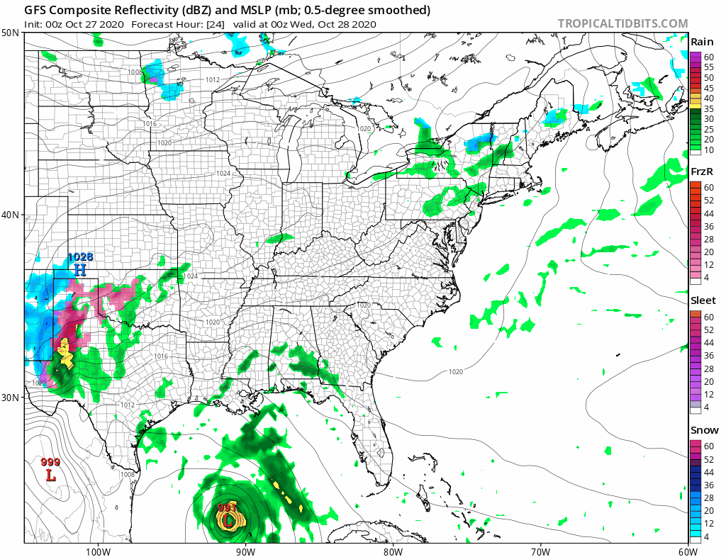
Satellite shows clouds just about everywhere and we even have a few showers on both the regional and local radars. These should diminish as the day wears on.
LOCAL RADAR NEW YORK CITY

LOCAL RADAR PHILADELPHIA


Late tonight into Wednesday morning we have a weak disturbance that will move through and there could be a few showers around in the hours surrounding daybreak but after those move out, I think we could see skies actually go partly sunny! Temperatures will reach the upper 50s and lower 60s.
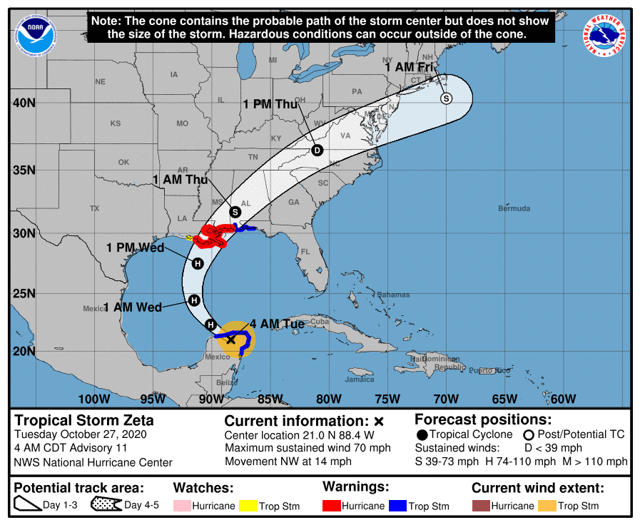
Back to Zeta now as it becomes a hurricane again later today and Hurricane Warnings are now up for Southeast Louisiana. Warnings extend from Morgan City Louisiana to the Mississippi Alabama border. Tropical Storm Warnings extend to the east into the westernmost part of the Florida Panhandle.
LOCATION…21.0N 88.4W
ABOUT 85 MI…140 KM ESE OF PROGRESO MEXICO
ABOUT 560 MI…905 KM S OF THE MOUTH OF THE MISSISSIPPI RIVER
MAXIMUM SUSTAINED WINDS…70 MPH…110 KM/H
PRESENT MOVEMENT…NW OR 305 DEGREES AT 14 MPH…22 KM/H
MINIMUM CENTRAL PRESSURE…984 MB…29.06 INCHES
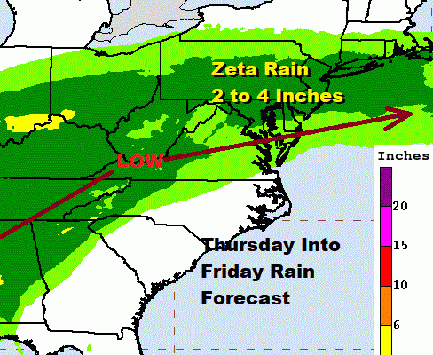
Zeta makes landfall late Wednesday and then heads northeast from there and rain moves into Eastern Pennsylvania to Southern New England. This is going to be a significant rain producer with several inches possible from Northeast Virginia to Southern New England.
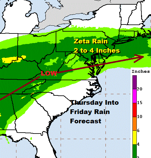
Zeta is going to react to an upper trough and energy from the Southern Plains and maintain some identity as a tropical or post tropical cyclone right through Friday.
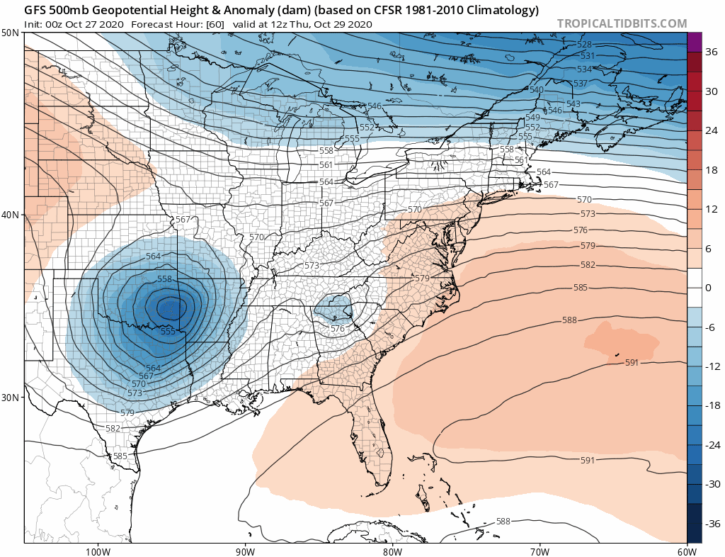
Models overnight have backed off in a big way about colder air getting involved and changing rain over to snow except for perhaps the coldest area in upstate NY and interior central New England. I am going to leave that door open as models continue to settle out that part of the equation. If we are dealing with just one low and in this case the models seem to be putting all its eggs into the remnant low of Zeta than cold air will just come in at the end with little consequence. If we go back to a two low solution which admittedly is a bit unusual, then it could be a different story.
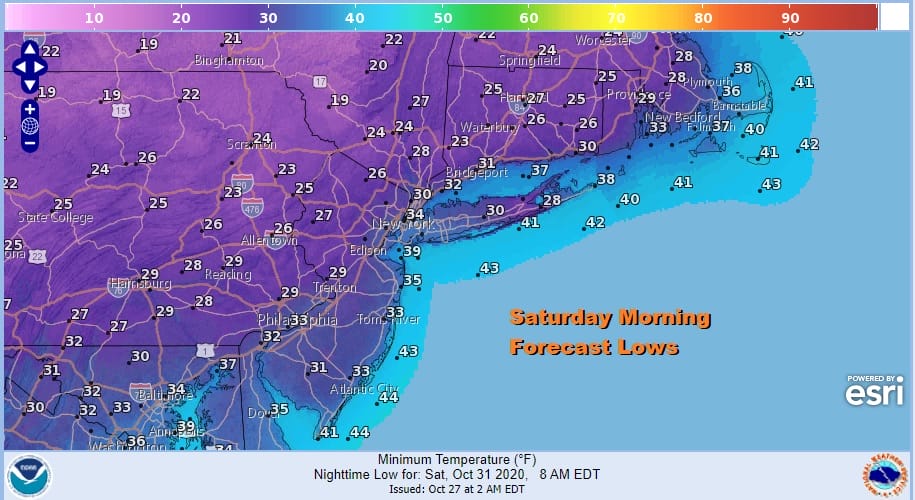
Either way we are going to turn very cold Friday night into Saturday morning with lows down to and under the freezing mark in many areas so get set for the first widespread freeze of the season Halloween morning. The weekend itself will be chilly but at least we will see some sunshine both Saturday and probably most of Sunday. Saturday’s highs will be in the 40s but Sunday we should be back in the 50s.
BE SURE TO DOWNLOAD THE FREE METEOROLOGIST JOE CIOFFI WEATHER APP &
ANGRY BEN’S FREE WEATHER APP “THE ANGRY WEATHERMAN!
MANY THANKS TO TROPICAL TIDBITS FOR THE USE OF MAPS
Please note that with regards to any severe weather, tropical storms, or hurricanes, should a storm be threatening, please consult your local National Weather Service office or your local government officials about what action you should be taking to protect life and property.


