GFS Model Long Range Shows Deep Trough In The East
GFS Model Long Range Shows Deep Trough In The East
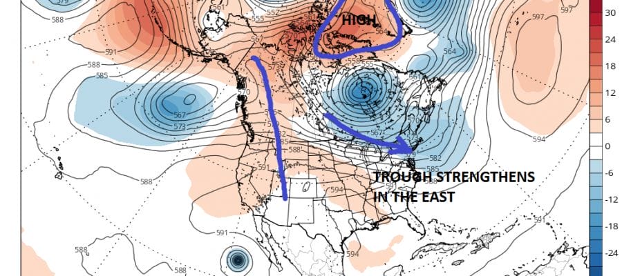
Over the last 2 months we have seen a rather persistent trough in the Eastern US with a persistent ridge in the west. This has at least prevented extreme heat (95-100 degrees or higher) from happening except for a couple of odd days here and there. Consecutive 90 degree or higher days have been limited to 3 days or so for most areas. At the moment the trough in the East is rather week which has allowed some hot humid weather to take over for a few days. Some troughing is going to flex its muscle a bit next week to bring some relief for a day or two. However the last 2 runs of the GFS and to some extent the European Model are showing signs that the trough may strengthen a bit. Of course we will need to see if this trend carries over through the next 4 or 5 days. Also we just had an upgrade of the GFS completed so let us see if the new upgrade improves the model. The last upgrade seemed to make it worse.
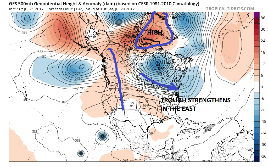
Im going to jump to next weekend after we get another warm front cold front combination late next week. This upper air would suggest a fairly decent push of cooler drier air into the Northeast & Middle Atlantic States. It would certainly continue the idea of short bursts of very warm to hot humid air for a day or two before a front pushes through.
GFS MODEL UPPER AIR DAY JULY 31-AUGUST 3 CLICK TO ANIMATE
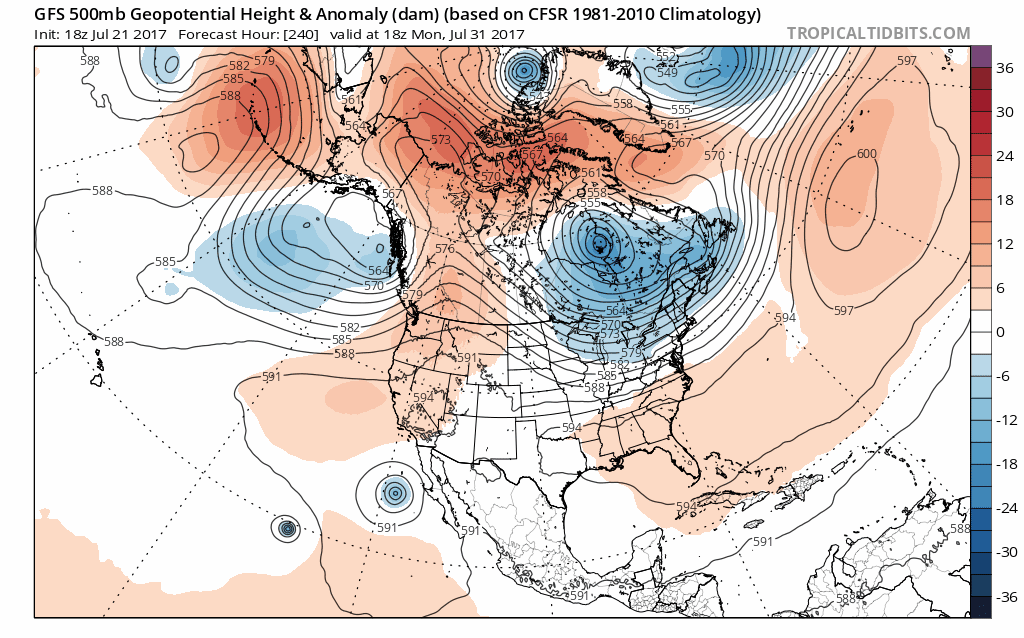
The GFS model holds the upper air storm in Eastern Canada depicted above right through the first week of August. This would create cooler than average conditions in the northeast into the Middle Atlantic States. The upper ridge flies up in the west into Western Canada. We also have a little bit of blocking with higher than average pressures in the North Atlantic holding this flow in place. Also much of the polar regions will be seeing higher than average pressures which displaces the jet stream further south. We have been contending that IF the trough in the east idea continues into August, we will see more robust cooler air masses moving southward and the GFS model would seem to support this idea at least for now. Also the persistence of the ridge in the Western US would lend credence to the idea since the trend is your friend. Breaking down a major ridge like the one in the west would require a lot of work atmospherically so for now it would seem safer to just go with the flow.
As far as the tropics are concerned the Atlantic ridge in suppressed far to the south along and just north of 30 degrees north. This would lend a westerly component to tropical waves in the Atlantic but it would continue the trend we have seen so far of these systems being pretty far to the south. We have also seen rather hostile upper air conditions across the Atlantic Basin thanks to strong upper lows in the higher levels of the atmosphere. There is some hint on models that this could change come early August which would be in line with climatology.
MANY THANKS TO TROPICAL TIDBITS FOR THE WONDERFUL USE OF THE MAPS

GET JOE A CIGAR IF YOU LIKE!
LANDSCAPE COMPANIES FOR YOUR SPRING SUMMER FALL NEEDS
LONG ISLAND ROCKLAND COUNTY Connecticut

![]()

ROCKLAND COUNTY TRI STATE SNOW REMOVAL JOHNSTOWN PA


FiOS1 News Weather Forecast For Long Island
FiOS1 News Weather Forecast For New Jersey
FiOS1 News Weather Forecast For Hudson Valley
NATIONAL WEATHER SERVICE SNOW FORECASTS
LATEST JOESTRADAMUS ON THE LONG RANGE
Weather App

Don’t be without Meteorologist Joe Cioffi’s weather app. It is really a meteorologist app because you get my forecasts and my analysis and not some automated computer generated forecast based on the GFS model. This is why your app forecast changes every 6 hours. It is model driven with no human input at all. It gives you an icon, a temperature and no insight whatsoever.
It is a complete weather app to suit your forecast needs. All the weather information you need is right on your phone. Android or I-phone, use it to keep track of all the latest weather information and forecasts. This weather app is also free of advertising so you don’t have to worry about security issues with your device. An accurate forecast and no worries that your device is being compromised.
Use it in conjunction with my website and my facebook and twitter and you have complete weather coverage of all the latest weather and the long range outlook. The website has been redone and upgraded. Its easy to use and everything is archived so you can see how well Joe does or doesn’t do when it comes to forecasts and outlooks.
Just click on the google play button or the apple store button on the sidebar for my app which is on My Weather Concierge. Download the app for free. Subscribe to my forecasts on an ad free environment for just 99 cents a month.
Get my forecasts in the palm of your hand for less than the cost of a cup of Joe!
![]()