
Gfs Model & Euro Weather Outlook For Rain & Tropics
Gfs Model & Euro Weather Outlook For Rain & Tropics
The easy part of this forecast is from now until Wednesday. The current cool air mass moves out and then as an upper ridge builds into the Eastern US it will mean for very warm temperatures Monday through Wednesday with highs Monday in the mid 70s to near 80 and in the low to mid 80s in some places Tuesday and Wednesday. This will create the possibility of record highs in some areas. This ridge is well to the north of its normal position. As a result it is creating below normal surface pressures in the Bahamas and Eastern Gulf of Mexico southward into the Caribbean. This opens the door for the possibility for something to spin up in that region next week but the question is where. The other question is whether it gets involved in wholesale pattern changes that will begin to occur later next week. The outcome of all this could be a drought denting rain for this area which continues to sink deeper and deeper into severe drought conditions. Otherwise it could be another lost opportunity.

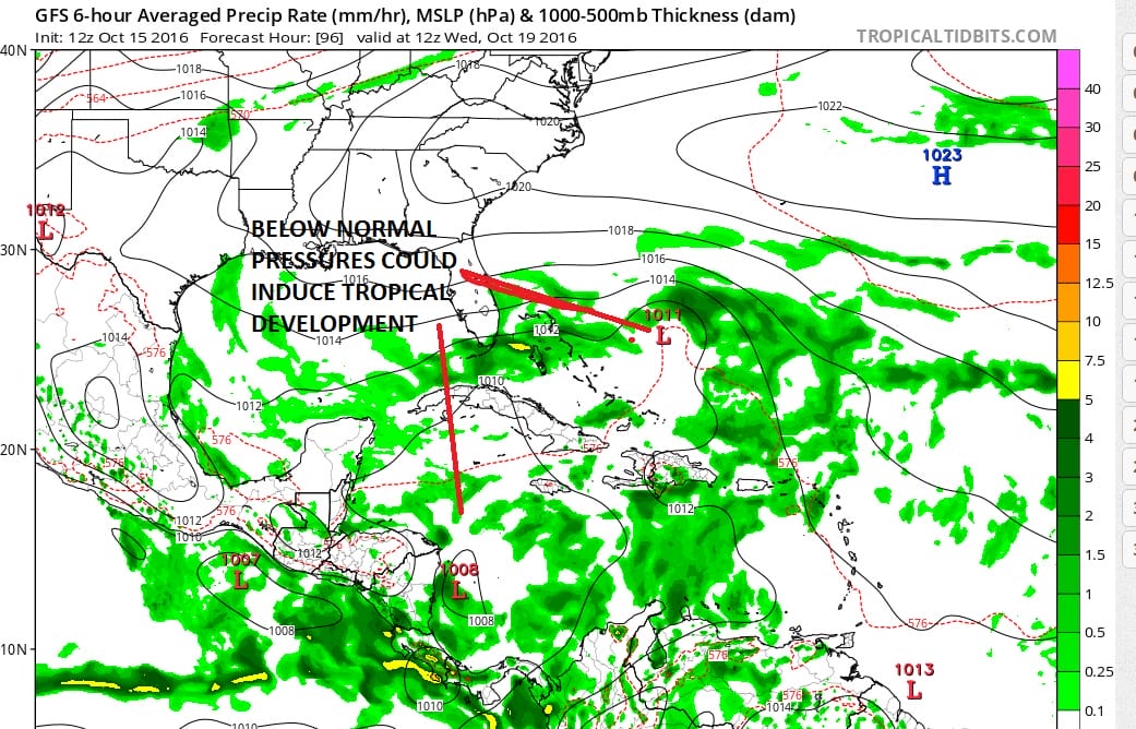
As we look ahead into later next week on the question of where, Models focus on two areas. The first is in the Southern Caribbean. Last week for a number of runs we saw numerous attempts at developing a hurricane in that region however models have backed away from this. Attention seems to be shifting to the Bahamas where a low is forecast to spin up and gradually move northwest or northward. All of this is happening as a trough swings out of the western states and heads for the Ohio Valley.

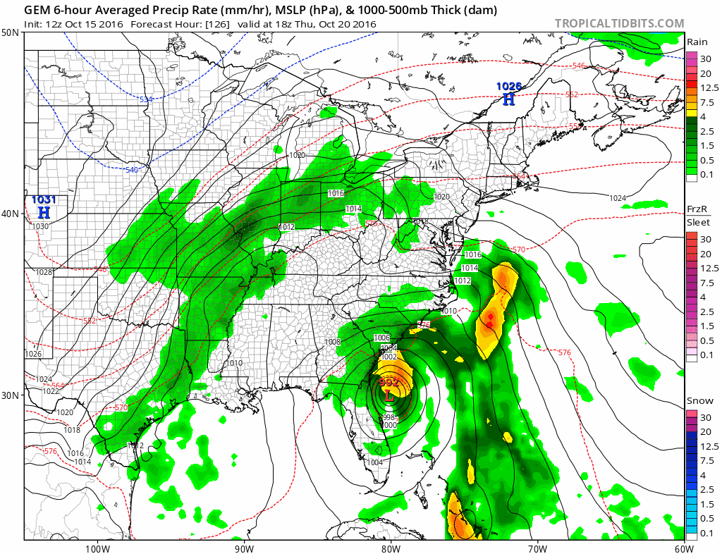
The gfs model solution looks to bring up a low up the coast. Now this could be anything from non tropical to tropical or something in between. The ideal would be something tropical in nature that creates more of a rain event than anything else as it moves right up the coast. But whether this happens or not hinges on struture of the system coming out of the west and what happens to it when it reaches the East.

The GFS model upper air is very dynamic as it develops a strong upper air low and attempts to lift it northeastward. The northern part of the jet stream is weak enough to allow this to happen. This would bring rain from both the coastal low (what ever that winds up being) to a second non tropical low that develops a day or so later. The European model on the other hand has the northern jet overwhelming the northeast and would keep everything suppressed south and east.

The European solution is actually quite similar to what the GFS model did overnight in the mid cycle run. The Canadian run has the strongest tropical solution here with a rather robust tropical storm moving northward just inland of the coast. That is because the Canadian phases the two jet streams.
Obviously no answer can be given here today on what is going to happen. Given the drought pattern you have to wonder whether the flat European model idea is far more likely to occur than the other two models. However the European model has had issues for months now which makes it almost as useless as the other two in the long range. We will see how this all plays out but I do think something is going to come out of the subtropics later next week. Whether it brings us much needed rain is another matter entirely.
MANY THANKS TO TROPICAL TIDBITS FOR THE WONDERFUL USE OF THE MAPS

MENTION JOE CIOFFI AND GET A 5% DISCOUNT
WINTER 2016-2017 PART 1 OCEAN WATER TEMPERATURES
WINTER 2016-2017 PART 2 ARCTIC SEA ICE AND SIBERIAN SNOW COVER
FiOS1 News Weather Forecast For Long Island
FiOS1 News Weather Forecast For New Jersey
FiOS1 News Weather Forecast For Hudson Valley
NATIONAL WEATHER SERVICE SNOW FORECASTS
LATEST JOESTRADAMUS ON THE LONG RANGE
Weather App

Don’t be without Meteorologist Joe Cioffi’s weather app. It is really a meteorologist app because you get my forecasts and my analysis and not some automated computer generated forecast based on the GFS model. This is why your app forecast changes every 6 hours. It is model driven with no human input at all. It gives you an icon, a temperature and no insight whatsoever.
It is a complete weather app to suit your forecast needs. All the weather information you need is right on your phone. Android or I-phone, use it to keep track of all the latest weather information and forecasts. This weather app is also free of advertising so you don’t have to worry about security issues with your device. An accurate forecast and no worries that your device is being compromised.
Use it in conjunction with my website and my facebook and twitter and you have complete weather coverage of all the latest weather and the long range outlook. The website has been redone and upgraded. Its easy to use and everything is archived so you can see how well Joe does or doesn’t do when it comes to forecasts and outlooks.
Just click on the google play button or the apple store button on the sidebar for my app which is on My Weather Concierge. Download the app for free. Subscribe to my forecasts on an ad free environment for just 99 cents a month.
Get my forecasts in the palm of your hand for less than the cost of a cup of Joe!
![]()

