GFS Long Range Model Winter Storm Threat

Once the arctic air departs it looks like we will transition into a milder pattern later next week. However in between that it looks as if both the GFS and the Canadian models are hinting at a winter storm threat next week. How that threat ultimately plays out however remains to be seen. Tonight’s GFS and Canadian model runs show similar ideas with regards to low pressure that will develop in the Gulf states and the eventually head up the east coast.
GFS Long Range Model Winter Storm Threat GFS AND CANADIAN MONDAY NIGHT FORECAST

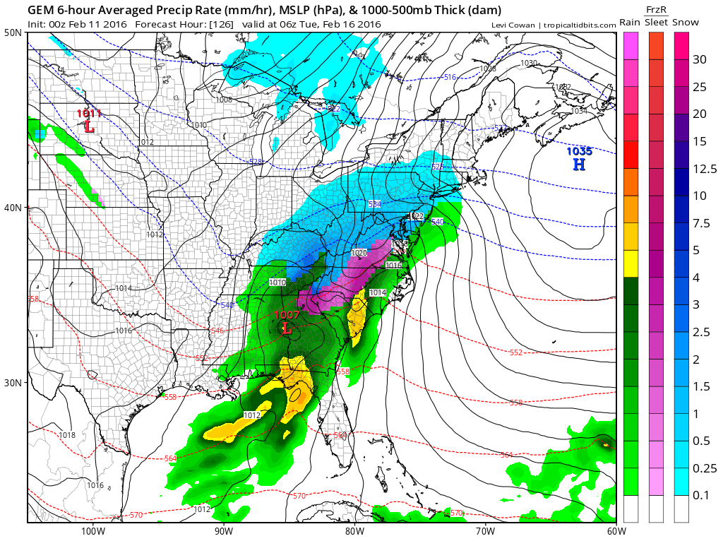
The maps above are for Monday evening and both models show low pressure making a turn up the Appalachians. Both models also show pressure weakness along the coast with a warm front that sets up from the Carolinas northeasward. Where they differ (AND THIS IS VERY IMPORTANT) is how they handle the high and the arctic air mass after it departs. The GFS takes the high straight out and attempts to dam cold air down the Appalachains. The Canadian as more of the high further north and has a stronger wedge down the mountains trapping more cold air. The high is going out and is never going to be in an ideal position. However cold air in cases like this will inevitably be more important than the models show. How this gets rectified over the coming days will be key to the outcome.
GFS Long Range Model Winter Storm Threat GFS CANADIAN TUESDAY NIGHT FORECAST
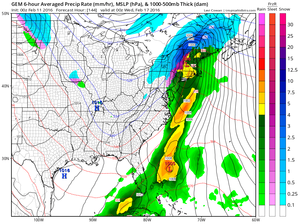
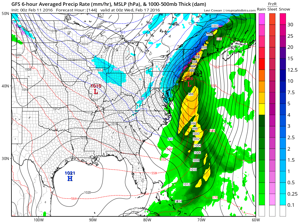
Both models change the snow to rain along the coast. Where the difference is lies in the more dynamic GFS with a deep low just offshore while the Canadian basically takes a deepening wave northward just inland of the coast or basically a coast hugger. The upper air profile of the models show the difference.
GFS Long Range Model Winter Storm Threat GFS CANADIAN UPPER AIR DIFFERENCES
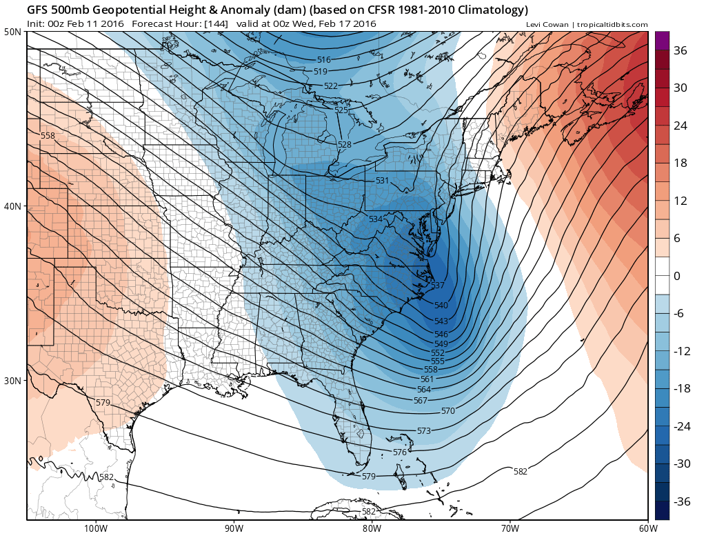

Notice the difference in the jet stream patterns of both models. The GFS has a much more dynamic upper air as the trough phases and goes “negative” or the axis runs northwest southeast. That causes the low to deepen considerably as it moves up the coast. It also allows cold air to come back in on the back side and change the rain back to snow along the coast before it ends. The Canadian never really does this and keeps the two stream a bit more separated and it never swings the bottom of the trough around. The result here is a less deep low that just runs northward and done.
GFS Long Range Model Winter Storm Threat GFS CANADIAN SNOWFALL FORECAST
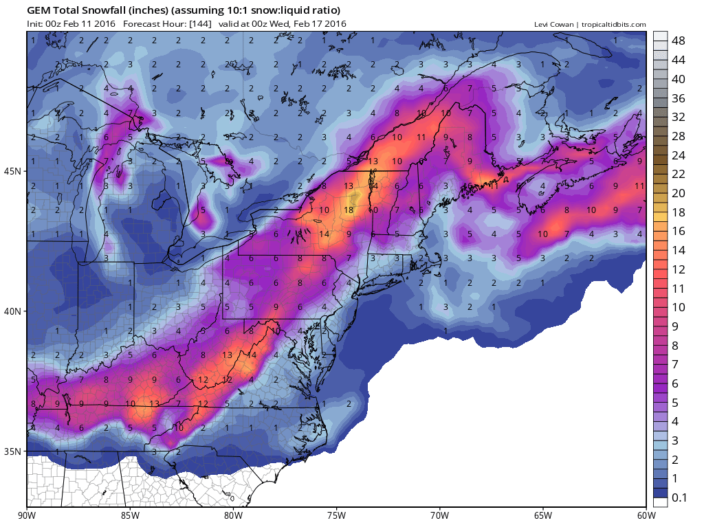
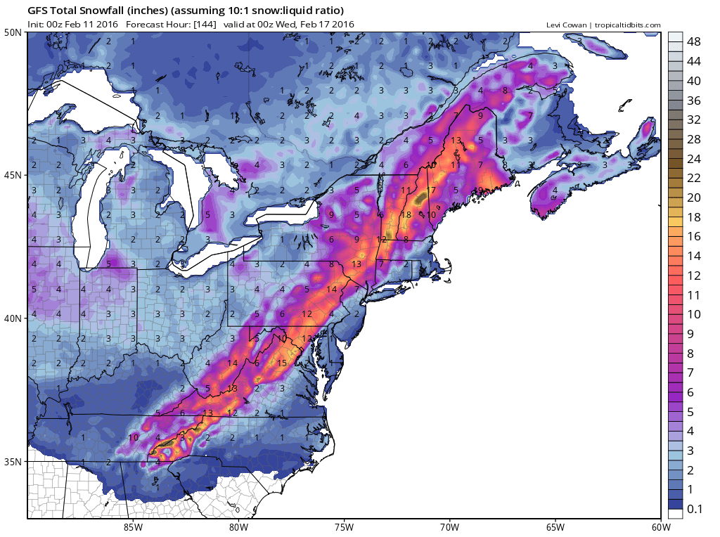
Here are the snowfall forecast maps for the two models. PLEASE NOTE I AM NOT FORECASTING THIS!!! The GFS would have a snowstorm just inland and it actually would bring the first big snow to inland areas all winter while the Canadian with its less dynamic look would have less snow further west in terms of totals.
Now let’s explore some variables. First off we need to figure out if the arctic air mass is more important and hangs around longer. Second thing is whether the upper air phases or doesn’t phase. Models for the last month have been notorious for showing phases early that never seem to occur and southern stream energy winds up getting lost as it lifts northeastward. Third is the tendency for westward shifts of ocean tracking systems. Will the same apply here. And finally will the European model have a further east solution then it did on the day run.
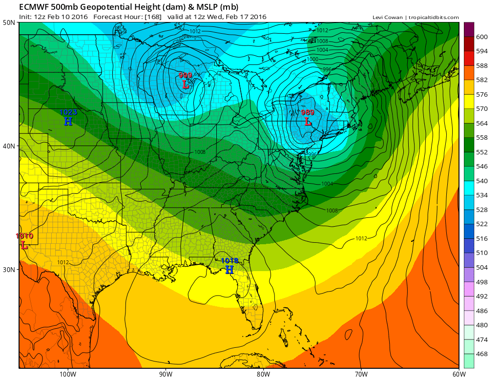
GFS Long Range Model Winter Storm Threat EUROPEAN MODEL VIEW FROM WEDNESDAY AFTERNOON
We could also wind up with a situation where we have a little bit of everything with regards to a final outcome. Cold air could be more important and a front end heavy snow area could develop that changes to rain along the coast but takes a long time to work its way inland. Areas to the south might see cold air dammed down with a snow to a prolonged icing event before going to rain. As I recall we had a situation last winter like this where areas south of New York City went from snow to ice for a long time while a change to rain actually occurred in areas to the north first. In the end at this point there are as always way too many pieces of the puzzle to sort through. One thing I do know is that this winter has been one where strange things have happened and in several instances have happened at the last minute so discount nothing at this point.
Once this storm is done the pattern will relax again for a few days in another realignment. All signs to me point to a return to a strong ridge in the west and an alley way for cold air to return to the east from Canada. There appears to be another significant warming event that will occur in the arctic and this is has led to storminess in the east along with cold air. The wide swings in both directions will continue and there looks to be more storminess ahead as we head toward the latter part of February and the beginning of March.
GFS CANADIAN MODEL ANALYSIS AND THE LONG RANGE VIEW
NATIONAL WEATHER SERVICE SNOW FORECASTS
LATEST JOESTRADAMUS ON THE LONG RANGE
Weather App

Winter is here! Don’t be without Meteorologist Joe Cioffi’s weather app. It is a complete weather app to suit your forecast needs. All the weather information you need is right on your phone. Android or I-phone, use it to keep track of all the latest weather information and forecasts. This weather app is also free of advertising so you don’t have to worry about security issues with your device. An accurate forecast and no worries that your device is being compromised.
Use it in conjunction with my website and my facebook and twitterand you have complete weather coverage of all the latest weather and the long range outlook. The website has been redone and upgraded. Its easy to use and everything is archived so you can see how well Joe does or doesn’t do when it comes to forecasts and outlooks.
Just click on the google play button or the apple store button on the sidebar for my app which is onMy Weather Concierge. Download the app for free. Subscribe to my forecasts on an ad free environment for just 99 cents a month.
Get my forecasts in the palm of your hand for less than the cost of a cup of Joe!
![]()