Gaston Strengthens & Tropical Depression Could Form Next 3 Days
Tropical Storm Gaston Strengthens
New Tropical Depression Could Form Next 3 Days
Some Models Aggressive On Threat To Florida

The loop above is the disturbance known as 99L which is continuing to move to the west toward the Leeward Islands. Overnight convection has continued to increase as it moves away from the dry air environment that it has been travelling in for the last week. At the very least showers and gusty winds will be moving through the Leeward Islands and then spread to Puerto Rico and the Virgin Islands over the next couple of days The wider view shows the wave approaching and what is left of Fiona to the northwest.

The loop below here shows the wave and also shows strengthening Tropical Storm Gaston to the east. Gaston is likely to become a hurricane over the next day or 2 as it continues to move west and then northwest through a weakness in the upper ridge in the Atlantic.
...GASTON STRENGTHENS OVER THE FAR EASTERN TROPICAL ATLANTIC...


SUMMARY OF 500 AM AST...0900 UTC...INFORMATION
----------------------------------------------
LOCATION...13.2N 32.4W
ABOUT 545 MI...880 KM W OF THE SOUTHERNMOST CABO VERDE ISLANDS
MAXIMUM SUSTAINED WINDS...50 MPH...85 KM/H
PRESENT MOVEMENT...WNW OR 290 DEGREES AT 20 MPH...31 KM/H
MINIMUM CENTRAL PRESSURE...1004 MB...29.65 INCHES


WATCHES AND WARNINGS
--------------------
There are no coastal watches or warnings in effect.


DISCUSSION AND 48-HOUR OUTLOOK
------------------------------
At 500 AM AST (0900 UTC), the center of Tropical Storm Gaston was
located near latitude 13.2 North, longitude 32.4 West. Gaston is
moving toward the west-northwest near 20 mph (31 km/h) and this
general motion with a slight decrease in forward speed is expected
during the next couple of days.

Maximum sustained winds have increased to near 50 mph (85 km/h) with
higher gusts. Additional strengthening is forecast, and Gaston
is expected to become a hurricane by Wednesday.

Tropical-storm-force winds extend outward up to 60 miles (95 km)
from the center.

The estimated minimum central pressure is 1004 mb (29.65 inches).

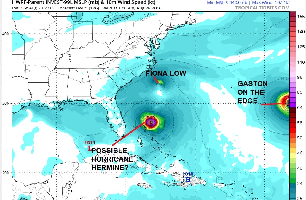
Now lets go back to 99L. The two most aggressive views are produced by the HWRF which actually is extremely aggressive showing a category 4 hurricane over the Bahamas this weekend. It actually even shows Fiona or a remnant low rotating around it. The HWRF however has been over aggressive with this system for days and I would discount the idea of a category 4 being in the Bahamas given that it is the only hurricane model at the moment showing this kind of aggressive development.
The European and Canadian models seem to be on the same page with this for a change. Even the Canadian today has a reasonable looking solution and not showing a thousand hurricanes rotating around each other.

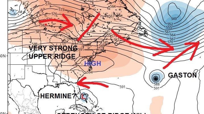
Both models show tropical storms near or east of the Bahamas by Saturday night. Both models respond by moving the tropical systems to the west. The main difference is the strength of the upper ridge. The European builds a very strong upper ridge to the northeast of the Tropical Storm which forces it to move much further south and west, taking it across Southern Florida Sunday evening and then turning it northward on the west coast of Florida as the ridge to the north begins to weaken.
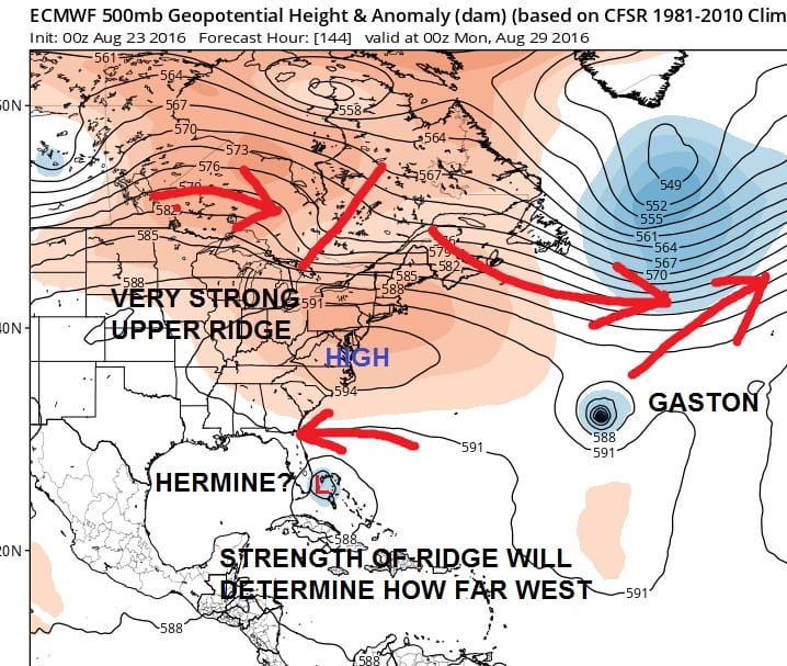
Now it should be noted that the NAM model out to 84 hours is on the same page as the European. It should also be noted that the GFDL model and the GFS model do not develop this system at all. I will say that when it comes to the GFDL, it is not as good as it once was. As for the GFS it has its moments and it has been going back and forth on this Hermine issue. As far as Gaston is concerned, models are clear about the weakness in the Central Atlantic which will cause Gaston to recurve and it is hard to argue against this idea with the strong westerlies across the Atlantic north of 35 degrees north.
Beyond day 5 and 6 models differ on the ridge and how fast it weakens as troughing develops over Eastern Canada and the northeast. I think at this point it is rather foolish to push this part of the equation along until we know if we are going to have a tropical storm to deal with in the first place and of what magnitude will it be.
FiOS1 News Weather Forecast For Long Island
FiOS1 News Weather Forecast For New Jersey
FiOS1 News Weather Forecast For Hudson Valley
NATIONAL WEATHER SERVICE SNOW FORECASTS
LATEST JOESTRADAMUS ON THE LONG RANGE
Weather App

Don’t be without Meteorologist Joe Cioffi’s weather app. It is really a meteorologist app because you get my forecasts and my analysis and not some automated computer generated forecast based on the GFS model. This is why your app forecast changes every 6 hours. It is model driven with no human input at all. It gives you an icon, a temperature and no insight whatsoever.
It is a complete weather app to suit your forecast needs. All the weather information you need is right on your phone. Android or I-phone, use it to keep track of all the latest weather information and forecasts. This weather app is also free of advertising so you don’t have to worry about security issues with your device. An accurate forecast and no worries that your device is being compromised.
Use it in conjunction with my website and my facebook and twitter and you have complete weather coverage of all the latest weather and the long range outlook. The website has been redone and upgraded. Its easy to use and everything is archived so you can see how well Joe does or doesn’t do when it comes to forecasts and outlooks.
Just click on the google play button or the apple store button on the sidebar for my app which is on My Weather Concierge. Download the app for free. Subscribe to my forecasts on an ad free environment for just 99 cents a month.
Get my forecasts in the palm of your hand for less than the cost of a cup of Joe!
![]()
![]()