Gaston Invest 91L Invest 99L
TROPICAL WEATHER VIDEO MODEL ANALYSIS SATURDAY
Gaston Invest 91L Invest 99L
Gaston Better Organized
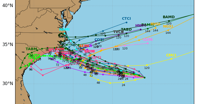
New Disturbance 91 L off North Carolina
99L Still Disorganized
We will start off with disturbed weather off the Carolinas and just southwest of Bermuda. Low pressure has developed here and we are seeing some thunderstorms developing this morning. The circulation center is on the edge of the thunderstorms. Some models over the last few days have been spinning this up and some have not. It seems like something is definitely trying here as it drifts slowly to the west. Because of all the dry air around it, development is likely to be slow but I would caution that sometimes we can see tropical storms flare up in a hurry so we will watch cautiously.

Invest 91L Spaghetti Plots
The vast majority of models here move this system toward the Carolinas over the next 3 or 4 days. After that a sharp turn to the right is likely because of a strong cold front and deep trough that is forecast to develop in the Eastern US.
Meanwhile INVEST 99L continues to be weak and disorganized with the weak surface low remaining on the western edge of the thunderstorms. This continues to track to the west. It seems that nothing is going to happen here until the low reaches the Southeast Gulf. Global models like the European and GFS model do absolutely nothing with this which may or many not mean anything when it comes to tropical systems.

Last night’s models have clustered tracks into the Northcentral Gulf of Mexico. The issue of development remains in question here. We will continue to punt here until we see some signs of organization developing.

Tropical Storm Gaston meanwhile continues to move away from the influence of a strong upper low to the southwest of the storm. Latest satellite loops here show the tropical storm is better organized and is likely to become a hurricane later today or tonight. This system remains no threat to land.

FiOS1 News Weather Forecast For Long Island
FiOS1 News Weather Forecast For New Jersey
FiOS1 News Weather Forecast For Hudson Valley
NATIONAL WEATHER SERVICE SNOW FORECASTS
LATEST JOESTRADAMUS ON THE LONG RANGE
Weather App

Don’t be without Meteorologist Joe Cioffi’s weather app. It is really a meteorologist app because you get my forecasts and my analysis and not some automated computer generated forecast based on the GFS model. This is why your app forecast changes every 6 hours. It is model driven with no human input at all. It gives you an icon, a temperature and no insight whatsoever.
It is a complete weather app to suit your forecast needs. All the weather information you need is right on your phone. Android or I-phone, use it to keep track of all the latest weather information and forecasts. This weather app is also free of advertising so you don’t have to worry about security issues with your device. An accurate forecast and no worries that your device is being compromised.
Use it in conjunction with my website and my facebook and twitter and you have complete weather coverage of all the latest weather and the long range outlook. The website has been redone and upgraded. Its easy to use and everything is archived so you can see how well Joe does or doesn’t do when it comes to forecasts and outlooks.
Just click on the google play button or the apple store button on the sidebar for my app which is on My Weather Concierge. Download the app for free. Subscribe to my forecasts on an ad free environment for just 99 cents a month.
Get my forecasts in the palm of your hand for less than the cost of a cup of Joe!
![]()
![]()