
Furnace for Christmas Eve! The Blow torch isn’t a strong enough pattern description!
Forget the blow torch and let’s got straight for the furnace. Tonight’s long range models takes us through the rest of the month and specifically I want to show you the temperature map for Christmas Eve. If this happens, and I can’t see why it couldn’t, this could be an historic Christmas Eve.
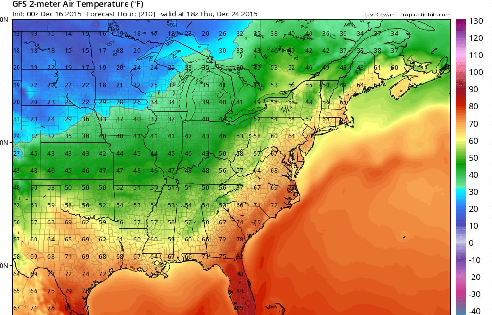
Yes Virginia you are getting a furnace for Christmas Eve! Those are 70s to New York City and mid 60s as far north as Maine! The New York City record for Christmas Eve is 63 back in 1996 and this would shatter that record. The Christmas Day record is 64 back in 1982. Long range gfs model has us back into the upper 40s and low 50s on Christmas day. From the standpoint of winter weather lovers this is truly as ugly as the long range can get.

Here is the corresponding surface map for Christmas Eve which really brings this to an absurd level of insanity. Not only do you have a furnace but you have showers and thunderstorms to deal with as well! The only thing that is missing from this equation is a hurricane off the east coast!
The only thing I can offer in all this is a stock market analogy. When stock markets are in a bear phase or selling phase, the end doesn’t come until there is a exhaustive phase of selling. The selling goes on for days or even weeks and is almost unrelenting until finally the last seller has sold and markets then bottom and reverse. Perhaps this is the point we are at in this pattern where we are entering an exhaustive phase where the warmth is just seemingly unrelenting until one day the pattern finally breaks down. The question however remains unanswered. Is this the exhaustive phase?
SHORT RANGE FOR NEW JERSEY CONNECTICUT AND PENNSYLVANIA
JOESTRADAMUS TUESDAY VIDEO ANALYSIS AND LONG RANGE FORECAST