
Forecast model gfs has been moving back and forth from run to run yet it seems to have really taken on quite a bit tonight as it is indicating a gradual change to a colder and stormier look. Im going to say right off the bat that I remain highly skeptical of the the specific look here for a number of reasons which I have mentioned numerous times. Howver this gfs forecast model run is by far the coldest looking and the most dynamic of the last dozen runs.
It basically does 2 things. It is changing the pattern across Canada to one which opens the door for colder air to come back into Canada itself and then into the United States. It does this by sending a series of storms from the strengthening subtropical jet and as each system goes by it rearranges the pattern, first across Canada and then across the eastern United States.
I want to emphasize the confidence factor here is very low given the usual shifts the model makes from run to run. But it does appear that something is going on that is causing this to occur. Perhaps it is the crashing North Atlantic Oscillation which is forecast to negative over time, or it could be the North Pacific influences are beginning to flex some muscle. The standout to me was the very powerful subtropical jet that is getting in position to send one storm after another crashing into the west coast. This part of the equation we seem to have fairly set. The question is whether the model is correct with the changes in Canada.
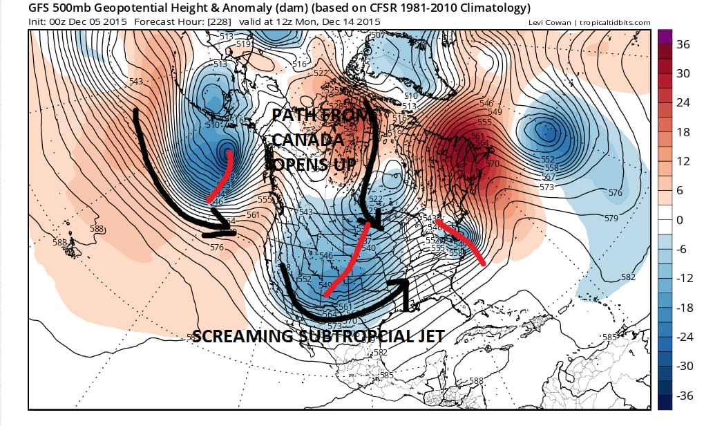
This map is for day 9 of the sequence which actually I view as a positive because it least it is inside day 10 so it gives us a shade more reliability. The first of a series of systems is going by at this point and you can see the second and third systems lining up. Obviously this all going to change quite a bit but if the model is correct in the change in the overall look across North America, then perhaps the pattern is indeed going to at least shift a bit and open up the door to some possibilities down the road.
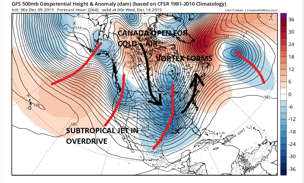
Now we are at day 11 and this is as cold and as deep a trough that we have seen for quite a long time…probably not since the trough that brought the cold shot back in mid October. We see the appearance of a vortex near Hudson Bay. The subtropical jet is booming with one system after another. The pacific looks like a moisture firehose. Ridging is builing across the north Atlantic into Southern Greenland. An upper low is out in the central Atlantic which forces a ridge between it and the coast.
Again the question through all of this is whether this is even close to reality. Guess what..we don’t know so the best we can do is punt again until the next 2 runs. My suspicion is that the next run will probably back off to some degree from this. I wouldn’t not be at all surprised to see this run be undone tomorrow like today’s day run did. Skepticism abounds which is probably a good thing. Forecast model runs will continue overnight and we will analize the Europeans adventure along with the Canadian and others in the morning.
SHORT RANGE FORECAST FOR THE WEEKEND
SNOW CONTINUES IN THE WEST BUT IS LACKING IN THE EAST OVER THE NEXT 10 DAYS…SKIING OUTLOOK