FLORENCE ON VERGE OF HURRICANE STATUS
STEADY STRENGTHENING SHOULD BEGIN WEST OF 60 DEGREES WEST
MAJOR HURRICANE TO THREATEN THE CAROLINA COAST LATE WEEK
TROPICAL STORM ISSAC STRENTHENING, HURRICANE THREAT TO THE LEEWARDS
TROPICAL STORM HELENE LASHING CABO VERDE ISLANDS
At the moment we have three tropical storms in the Atlantic Basin and a fourth tropical system is about to move off the African Coast. It seems likely that we should have 3 hurricanes on the map at this time tomorrow as all three, Florence, Issac, & Helene are getting better organized with favorable conditions for strengthening. Florence of course is front and center right now as the threat to the Carolinas continues to increase. A major hurricane is likely to make landfall in the Carolina’s late this week.
WIDE ATLANTIC TROPICAL SATELLITE

We continue to grapple with the same issues with Florence but we do know that it will miss the upper trough to the north of it today and Florence should start moving westward at a faster forward speed. We will be crossing 60 degrees west early Monday morning which has been a hurdle I set for Florence to pass and it seems that it will do this with ease. The ocean water temperatures between Bermuda and the Greater Antilles are over 2 degrees C above average. Ideal conditions aloft set the stage for possible rapid strengthening here. An Air Force plane is checking it out right now.
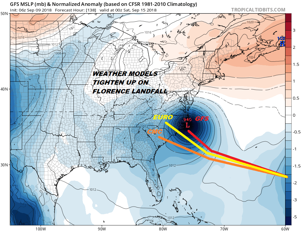
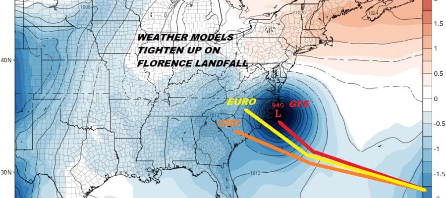
Weather models overnight continue to tighten up on the Carolina coast. Right now it would seem that Charleston would be the southern flank of a landfall possibility and perhaps Elizabeth City which lies near the northern portion of the Outer Banks. It also appears that it will be a category 4 hurricane as it approaches and, depending on how fast it is moving when it reaches the coast, either a 4 or a strong 3 at landfall. That would be bad enough but now a bigger issue lies ahead after landfall.
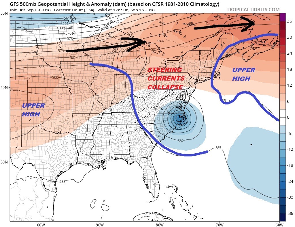
Every model shows the upper high splitting in two as steering currents collpase. This will leave Florence in a “no flow zone” or a “weak flow zone” for a couple of days. In other words it won’t move much. It is an usual situation to see a stall out like this in the Eastern US but the big upper high scenario means we have to wait for that jet stream to the north to drop down and pick Florence up and get it out of the way. The result for someone could be an excessive rain event occuring from the Carolinas northward and northwestward.
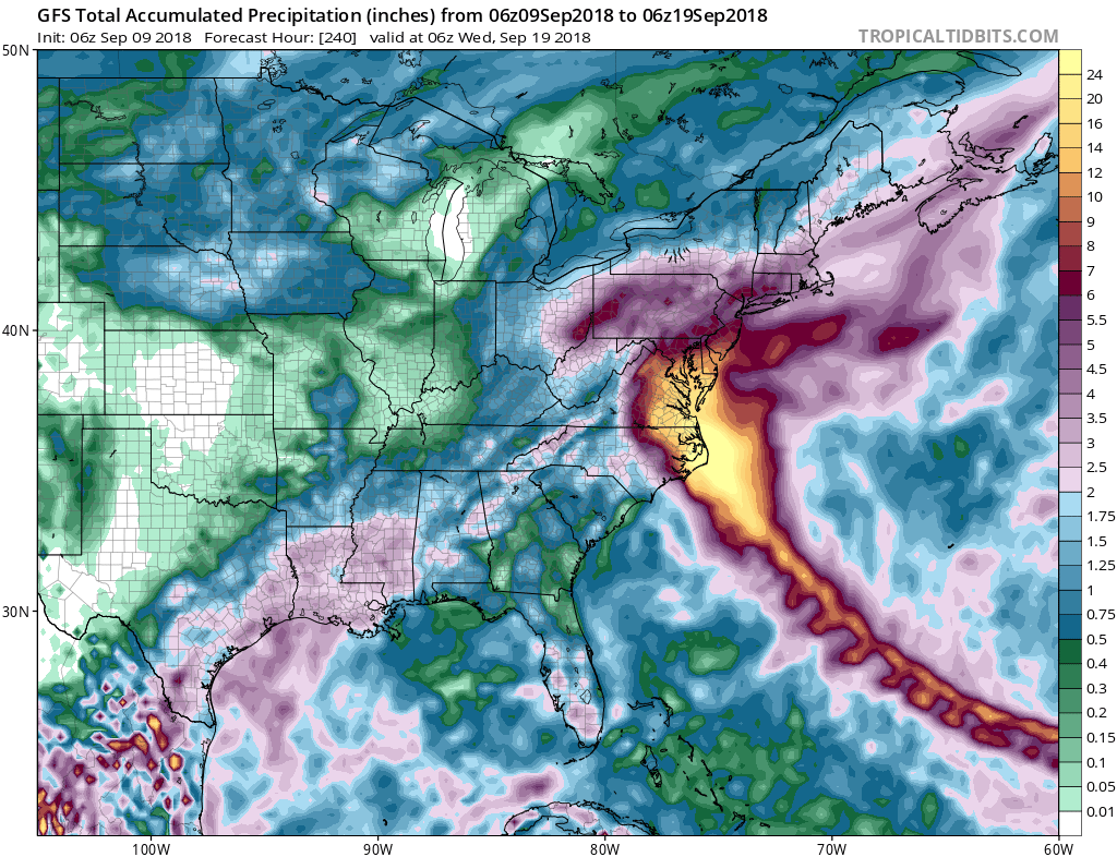
This is for illustration purposes only but the GFS which stalls this out just inland of the coast for at least 2 days creates huge rainfall amounts as far north as Delaware. We obviously aren’t forecasting specifics here but we just want to show you what is at stake if Florence winds up stalling out or moving slowly. We have a long way to go with Florence here but it is clear that the risk for the Carolinas is growing regarding landfall and the risk is also emerging for a huge rain event for the Carolinas and the Middle Atlantic States.
With regards to Tropical Storm Issac it appears that the risk is growing for the Leeward Islands later this week. We will be addressing that issue with a separate post later today.
THANKS TO TROPICAL TIDBITS FOR THE USE OF MAPS
Please consult your local National Weather Service office at weather.gov for the latest information on any tropical or storms or hurricanes that could be a threat to your area. Consult your local government officials regarding action you may need to take to secure life and property
FiOS1 News Weather Forecast For Long Island
FiOS1 News Weather Forecast For New Jersey
FiOS1 News Weather Forecast For Hudson Valley