Flooding Potential Saturday Into Sunday Morning
Flooding Potential Saturday Into Sunday Morning
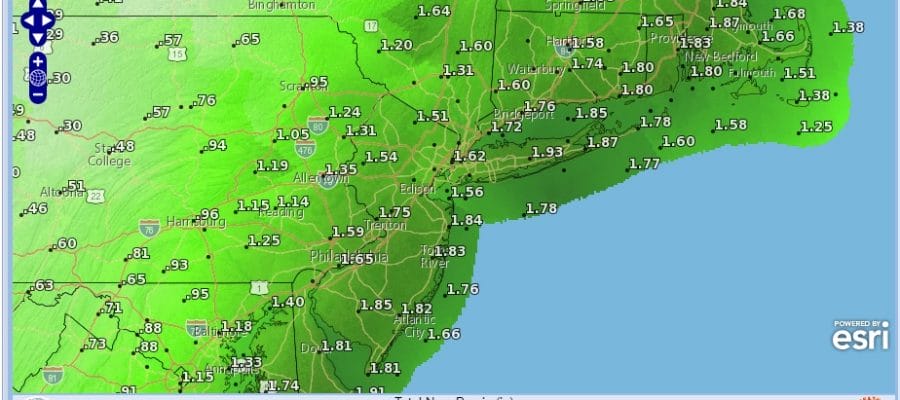
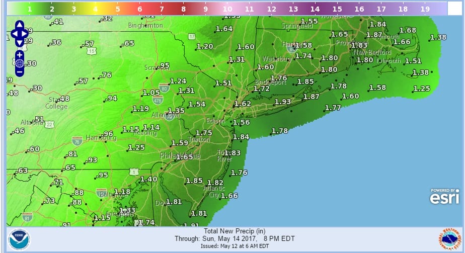
Rainfall amounts from the weather system for Saturday into Sunday morning should be on the order of 1.50 to 2.50 inches. I’ve been thinking on the order of a few (2 or 3) inches of rain all week even though models have been going up and down on amounts. Overnight weather models seem to be gravitating back to the above range so we will stick with that. This morning’s satellite loop shows a coastal storm well to the east spinning clouds back westward while the storm to the west is pushing clouds eastward. For at least part of today we should be in the middle with sunshine before clouds arrive from both directions. Temperatures will be topping out in the upper 50s to lower 60s.
SATELLITE LOOP

REGIONAL RADAR

LOCAL RADAR NEW YORK CITY

LOCAL RADAR PHILADELPHIA


Clouds will thicken up and rain will begin to move northward overnight across SE Pennsylvania and Southern New Jersey to near NYC by daybreak. Along the immediate coast this will be producing noreaster conditions for a brief time with gale force winds nearshore later Saturday and Saturday night.
The weather system is moving a little faster and while the bulk of the rain will be long gone before daybreak Sunday, the chance for showers will linger into Sunday along with a gusty wind. There is the potential for local flooding from this system. For now it would probably be the usual suspect spots. Temperatures Saturday with the rain and the ocean wind will be in the miserable low to mid 50s at best. Sunday we should be back up into the 60s. This is not going to be a nice weekend. The good news however is that with the blocking pattern breaking down warmer weather is on the way for next week.
 GET JOE A CIGAR IF YOU LIKE

LANDSCAPE COMPANIES FOR YOUR NEEDS
LONG ISLAND ROCKLAND COUNTY Connecticut

![]()

ROCKLAND COUNTY TRI STATE SNOW REMOVAL JOHNSTOWN PA


FiOS1 News Weather Forecast For Long Island
FiOS1 News Weather Forecast For New Jersey
FiOS1 News Weather Forecast For Hudson Valley
NATIONAL WEATHER SERVICE SNOW FORECASTS
LATEST JOESTRADAMUS ON THE LONG RANGE
Weather App

Don’t be without Meteorologist Joe Cioffi’s weather app. It is really a meteorologist app because you get my forecasts and my analysis and not some automated computer generated forecast based on the GFS model. This is why your app forecast changes every 6 hours. It is model driven with no human input at all. It gives you an icon, a temperature and no insight whatsoever.
It is a complete weather app to suit your forecast needs. All the weather information you need is right on your phone. Android or I-phone, use it to keep track of all the latest weather information and forecasts. This weather app is also free of advertising so you don’t have to worry about security issues with your device. An accurate forecast and no worries that your device is being compromised.
Use it in conjunction with my website and my facebook and twitter and you have complete weather coverage of all the latest weather and the long range outlook. The website has been redone and upgraded. Its easy to use and everything is archived so you can see how well Joe does or doesn’t do when it comes to forecasts and outlooks.
Just click on the google play button or the apple store button on the sidebar for my app which is on My Weather Concierge. Download the app for free. Subscribe to my forecasts on an ad free environment for just 99 cents a month.
Get my forecasts in the palm of your hand for less than the cost of a cup of Joe!


