Flood Watches Expanded Carolinas to New England
Heavy Rain Later Today, Thunderstorms Severe Weather

Flood Watches Expanded Carolinas to New England
Heavy Rain Later Today, Thunderstorms Severe Weather

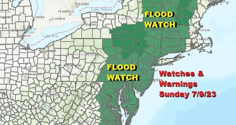
Flood watches continue in effect for Sunday and Sunday night as we watch low pressure move out of the Central Appalachians and head up the East Coast. Watches have been expanded to include North Carolina and much of Eastern Virginia. They continue northward to cover much of Central and Eastern Maryland, Delaware, all of New Jersey, much of NY State, Southern and Central New England. Two areas that ARE NOT included at the moment are Long Island, and Southeastern New England where forecast rain amounts are a little lower and below flash flood thresholds at least for now.
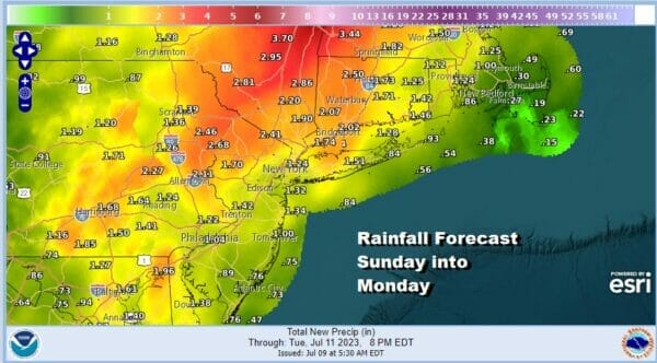
Rainfall amounts are forecast to be in the 2 to 3 inch range for much of the area however when it comes to thunderstorms there is, as always, lots of variablitly and it is possible that if a cluster of thunderstorms sits over one spot for any length of time, we could easily see amounts higher than that. This is especially true an in juiced up tropical air mass like we have today and tonight along the East Coast.
SATELLITE WITH LIGHTNING STRIKES

WEATHER RADAR

Most of the area is quiet this Sunday morning but we should begin to see rain on the radar gradually increasing from south to north as the day wears on. Coastal areas could be rain free for much of today while areas inland and west from Western New Jersey into Eastern Pennsylvania probably sees rain starting up by midday or early afternoon.

Severe weather becomes an issue later today for areas from Upstate NY southward into the Carolinas. The Storm Prediction Center has a marginal risk in northern areas which translates to a 5 to 15 percent chance while areas from Southeastern Pennsylvania and Delaware south are in a slight risk which translatest to 15 to 30 percent chance for thundertorms.
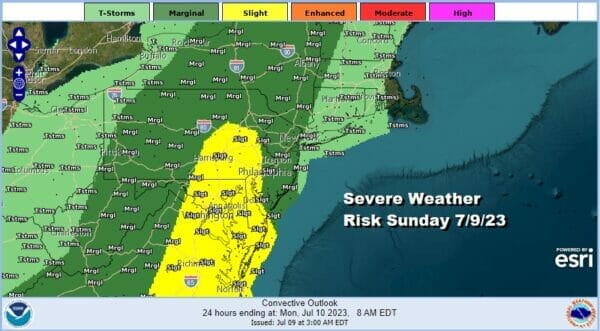
Think of it this way. In the marginal risk zone severe thunderstorms (50 mph winds) will be isolated in nature, while in the slight risk area severe thunderstorms would tend to be more numerous and scattered in clusters. Tornado risk is under 2 percent so while there might be the odd spin up, we should not see anything widespread. The primary issue would be gusty winds. Heavy rain is the bigger player here. Mid afternoon into the early morning hours Sunday will be the prime time for rain and it lasts well into Monday in Central and Northern New England.
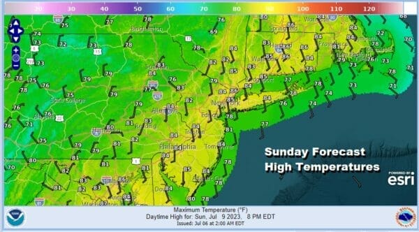
The juiced up tropical air means high humidity today and temperatures will reach into the 80s in many areas before the rains come and then settle back in the 70s. As the first batch of rain moves out later tonight we could see some more scattered showers and thunderstorms Monday. The Storm Prediction Center has a an area of marginal risk Monday for parts of Northern New Jersey to NYC, Long Island, Southern and Central New England.
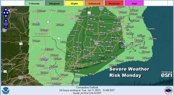
Monday will be a warm humid day with highs into the 80s. Downpours and thunderstorms are likely to pop up anywhere at anytime especially in the severe weather risk zone so that means the risk for localized flash flooding is likely to continue Monday. Dry weather will be moving in for Tuesday through Thursday though it will remain very warm and humid all this week.
BE SURE TO DOWNLOAD THE FREE METEOROLOGIST JOE CIOFFI WEATHER APP &
ANGRY BEN’S FREE WEATHER APP “THE ANGRY WEATHERMAN!
MANY THANKS TO TROPICAL TIDBITS FOR THE USE OF MAPS
Please note that with regards to any severe weather, tropical storms, or hurricanes, should a storm be threatening, please consult your local National Weather Service office or your local government officials about what action you should be taking to protect life and property.
(Amazon is an affilate of Meteorologist Joe Cioffi & earns commissions on sales.)


