Flood Watch New Jersey Southeast Pennsylvania Maryland Delaware
Flood Watch New Jersey
Southeast Pennsylvania Maryland Delaware
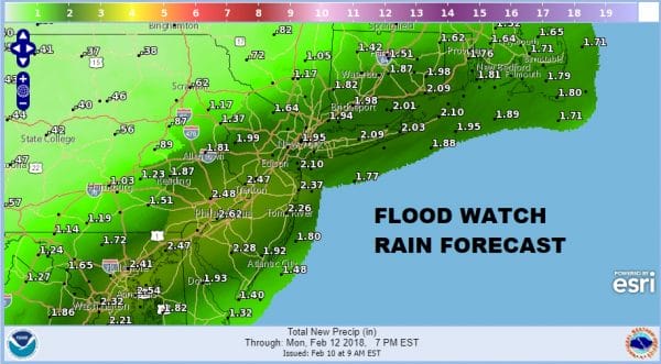
Radars are beginning to load up to the south and in fact the Storm Prediction Center has a marginal risk of severe weather indicated across the Central Gulf States. It is getting to that time of year where severe weather starts to pop up. For us it is the prospect for a 2 inch plus rainfall that has flood watches posted from New Jersey Route 78 Southward into the Middle Atlantic States. This is the third solid precipitation event in 6 days as the recent rainfall deficit is getting rapidly reduced.

The regional radar shows the wide spread rain beginning to move through Virginia and West Virginia. It will be spreading from southwest to northeast early this afternoon. Some of the rain will be heavy as it continues overnight and through most of Sunday.
Rainfall estimates on all the weather models are very consistent and have been for the last several days. There will be a band of 2 inch plus rainfalls that will set up across the Flood Watch zone.
Rain will last overnight and through most of Sunday and then begin to slide to the east Sunday evening though it may last longer in areas from Southern New Jersey southward. Monday should be drying out everywhere though there will be some leftover clouds.
FiOS1 News Weather Forecast For Long Island
FiOS1 News Weather Forecast For New Jersey
FiOS1 News Weather Forecast For Hudson Valley
NATIONAL WEATHER SERVICE SNOW FORECASTS
LATEST JOESTRADAMUS ON THE LONG RANGE


