
You need special flood insurance for rain. Homeowners doesn’t cover it. This is usually when you hear people say they have no insurance to cover for the devastating rains that are now falling throughout most of East Texas. The satellite loop remains impressive this evening and it appears that the low center with what is left of Patricia is combining with another non tropical low and beginning to move offshore.

The Corpus Christi Texas Radar below shows the back edge of the rain shifting northeast as the rain area begins to move northward into Southeast Texas where the axis of the heavy rains will be occuring tonight and Sunday. Along the coast a strengthening northeast wind will bring about some coastal flooding and beach erosion issues as well. So far it appears that this will remain non tropical in nature however the combination of the non tropical low and the tropical moisture source makes this as bad as any tropical storm that is totally tropical in nature..

The Houston Radar is now loading up with heavy rains moving north northeast and this will now pound those areas with 6 inches plus of rain overnight into Sunday.

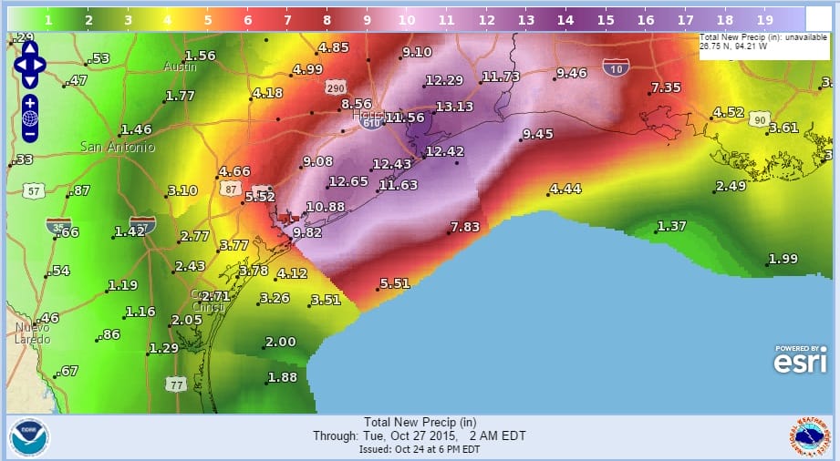
The rainfall forecast map shows rainfall between now and Tuesday morning and some of the amounts are astounding. You would think you were looking at a snowfall map! 12 inch plus rains in a large area in Southeast Texas into Southwest Louisiana will fall and local amounts to 20 inches are not impossible. Rains west and south of the main axis will be gradually tapering off tonight and Sunday but there could still be some residual downpours as the low offshore throws back some moisture to the coast in South Texas. All of this should gradually come to an end on Tuesday as the storm system moves northward up the Mississippi Valley.
.
Be sure to download my weather app and subscribe to my forecasts. The app is free and a subscription is just 99 cents a month.