DOWNLOAD MY NEW FREE JOESTRADAMUS WEATHER APP FOR ALL DEVICES
THE APP IS ABSOLUTELY FREE TO ALL BUT CONSIDERING SUBSCRIBING TO PATREON FOR A WEATHER EXPERIENCE FREE OF ADS, EXCLUSIVE VIDEOS FOR MEMBERS ONLY AND MUCH MORE…STARTS AT $2 A MONTH..MESSAGE ME AT ANY TIME
Flash Flood Watch Tonight Saturday Gusty Winds Coastal Flooding
The slow moving cold front is exactly that, slow moving. A strong storm is going to develop in the Southern Appalachians and creep slowly northward. This makes the eastward shift of heavy rains and thunderstorms a slow ordeal. At the moment we seem to be okay today regarding rain though there could be the occasional passing downpour on the radar. Otherwise we will be sitting in clouds with gusty southerly winds along the coast and temperatures that will reach the 60s for Long Island & Southern New England while areas to the west will reach the 70s. There is also a marginal risk for severe weather reaching Northern New Jersey and Northeastern Pennsylvania for when the downpours and thunderstorms arrive tonight.
SATELLITE

REGIONAL RADAR

Radars at the moment aren’t showing much nearby. Downpours and showers remain well to the west and we probably won’t see the steady rains get close until late this afternoon or early evening in Eastern Pennsylvania and Western New Jersey. It may take all night for showers and thunderstorms to shift eastward to the coastal areas.
LOCAL RADAR NEW YORK CITY

LOCAL RADAR PHILADELPHIA


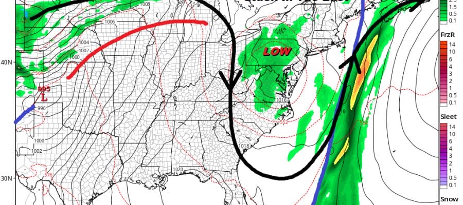
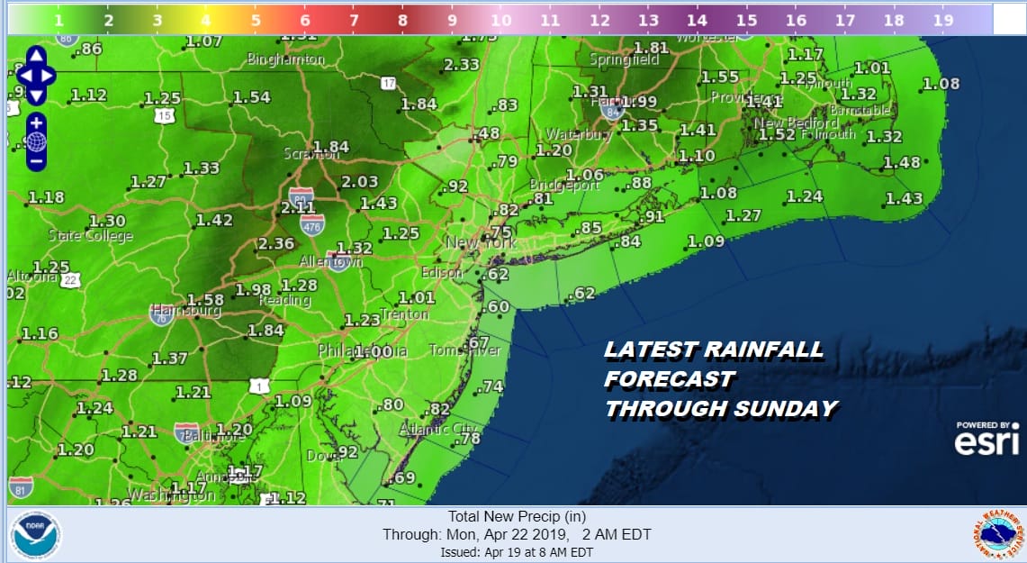
What makes this different from most other storms is the low is moving south to north rather than west to east. This limits the eastward progress of any rains so whoever gets under the heavy rain bands tonight and Saturday could be clobbered by 2 inches or more of rain while either side of this you wind up with half as much. Overnight the rains will focus on New Jersey and Eastern Pennsylvania, Saturday it shifts to the immediate coast Long Island & Connecticut.
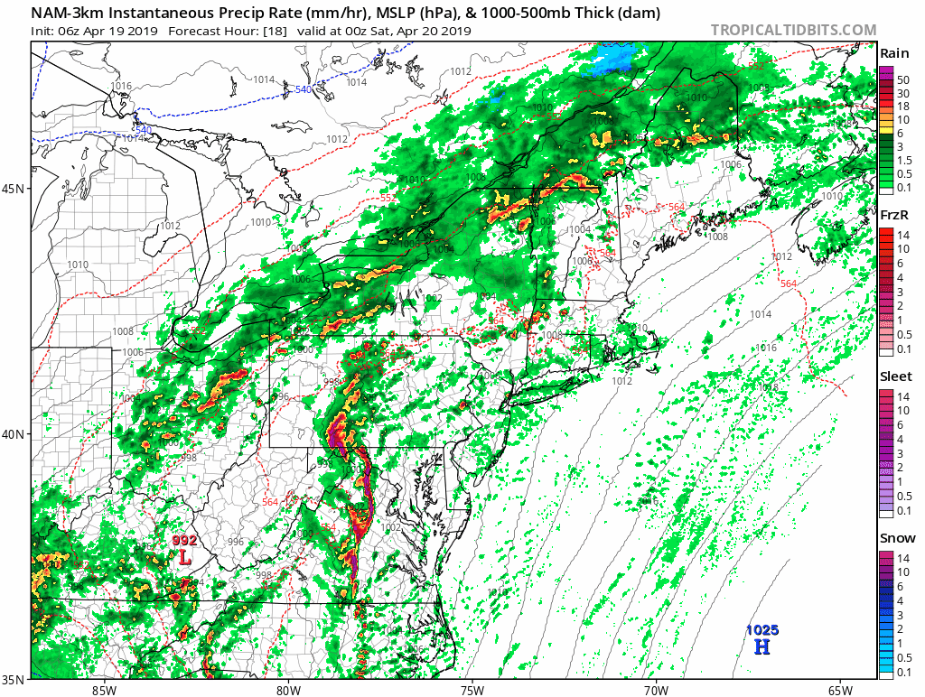
The NAM model above takes us from 8pm tonight through 8pm Saturday night. The bands of rain are heavy but narrow. To the west you can see the low pressure area moving almost due northward which limits the eastward progression. Rainfall forecast amounts below reflect the banded nature of this system and I would caution that these amounts could easily be double the forecast, depending on where the bands set up.
Now lets move on to Easter Sunday. The storm will be to our northwest and weakening but the upper air low will be lingering Sunday into Monday. While this will lead to clouds with some breaks of sun on Sunday it will also lead to pop up scattered showers and downpours. Temperatures Sunday will be in the 60s. The chance for showers will continue into Monday.
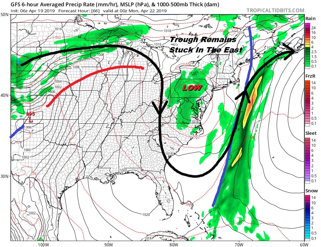
The issue is that the upper air storm just doesn’t get out of the way to the east. The front from Saturday will be stuck offshore and there could be a couple of waves moving along it that will keep the chance for showers here into Monday and Tuesday of next week.
MANY THANKS TO TROPICAL TIDBITS FOR THE USE OF MAPS
Please note that with regards to any tropical storms or hurricanes, should a storm be threatening, please consult your local National Weather Service office or your local government officials about what action you should be taking to protect life and property.


