
Fishing For A Pattern Change? Not Likely Anytime Soon as JOESTRADAMUS throws in the towel
Fishing and catching are two different things. That’s why they call it fishing. At some point it is time to recognize that there are no fish to catch and you should move elsewhere or come back another day. I’m thinking that it may be time to take the rod and reel and go home and come back another day. The El Nino pattern is just too dominant and too strong. Whatever the model was seeing, it does not appear to be really there. That I’m throwing in the towel is probably a good thing at this point. I may be a good contrary indicator.
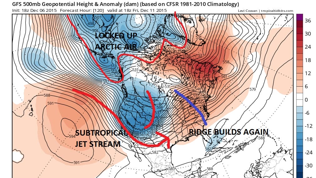
Since we have another week of nothing much happening here other than clouds from time to time, we will have to look ahead to next weekend in order to set up the next round of weather that will be effecting the northeast. There are no real surprises in store as 2 weak systems move through this week with little fanfare. The east coast ridge that has been here for the last 7 weeks remains in place and is set to fly up again late next week as another deep trough comes into the western states.

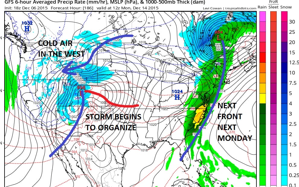
That trough gets ejected out as yet another one gets ready to dive into the western states. This sets up a very warm weekend ahead of the next cold front for next Saturday and Sunday with showers Sunday night into Monday as a cold front comes through. The disturbance in the west has some power to it so another storm begins to form in Colorado next Sunday and it will be destined to move east and then northeast during the middle of next week. The surface map below shows the set up for next Monday morning.
Once again up comes the ridge in the east after that system in the east exits as the trough in the west is very deep. It just seems that the GFS model is finally accepting the fact that the east ridge/west trough scenario is seemingly unbreakable at this point.
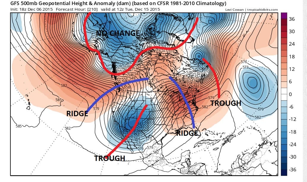

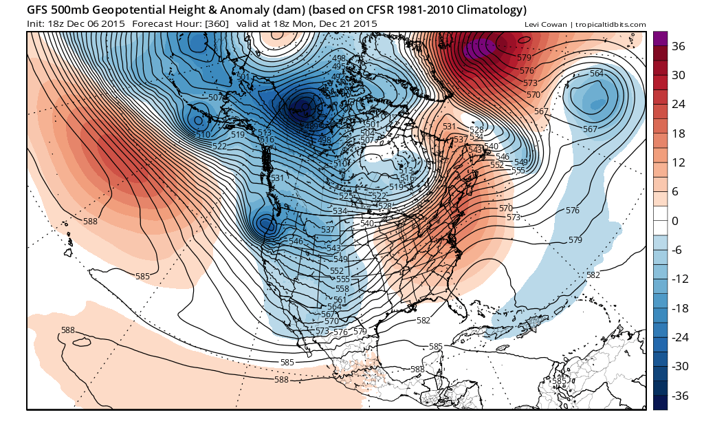
Notice that in this run there is no major storm developing going to the Great Lakes. The model’s grave error is in attempting to make major storms heading to the Great Lakes as it has done in several prior runs. It has backed off from this idea. The model has the Arctic pattern completely locked up with no change at all over the next 10 days.

Now just after day 10 we begin to see a little change occuring across Canada. Instead of dropping the next trough in the far west southward like the others, it kicks the mid nation trough east while it begins to carve out a new path across Southern Canada. The vortex complex in the Arctic splits apart but we really have to question whether this is real or not.
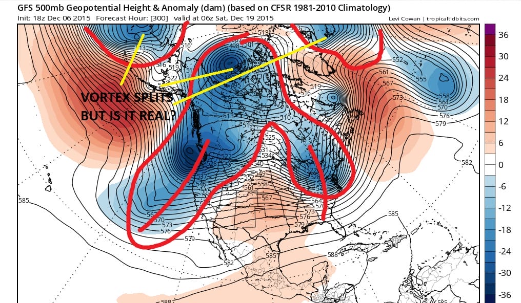
The look from here suggests that the trough in the east lifts out and the ridge will pop up once again though if there is enough of a change in the flow in Canada perhaps the ridge won’t pop up as strongly as the others of the past few weeks. Sure enough that is the case as the ridge does return and the trough in the west digs deep and hard. And yes one vortex does shift into Western Canada but the westernmost vortex sets up again over Alaska and the Aleutians.
I think that at this point it is probably safe to say that the El Nino inspired pattern is going to remain in place and other than transient cold air that comes in later in the period is just that. The model continues to throw up signs of change only to revert back to the west trough/east ridge dominant pattern. At this point it suggests that the pattern seems utterly unbreakable through Christmas at least. In the end as long as the vortex pattern across the northern Arctic regions remains in place, there will be no meaningful pattern realignment. My guess is that the GFS will from time to time still attempt to show pattern breakage but we now view this is unrealistic over the next 2 weeks at least. Kudos to those calling for a change in early Janaury because as each day goes by, their chances of being right increase. But rest assured I will be back tomorrow fishing for another pattern change possibility. JOESTRADAMUS will keep fishing until he catches something.
JOESTRADAMUS SATURDAY MORNING FORECAST ANALYSIS
SNOW CONTINUES IN THE WEST BUT IS LACKING IN THE EAST OVER THE NEXT 10 DAYS…SKIING OUTLOOK