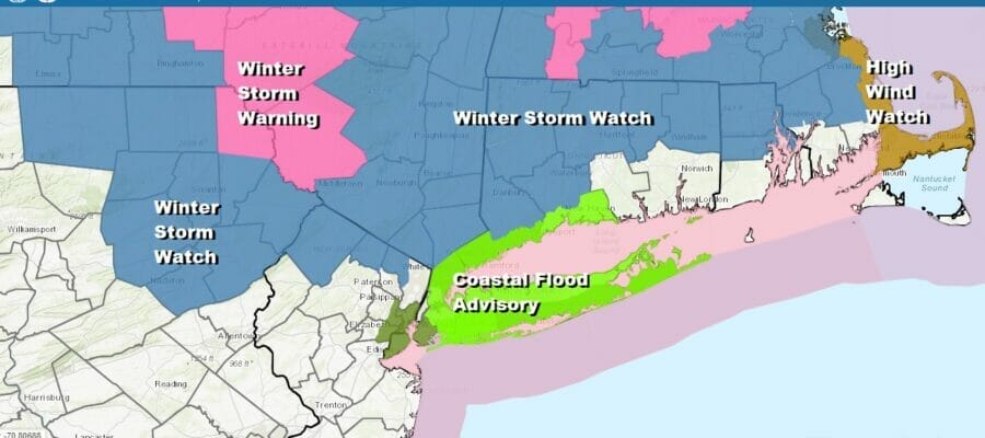
First Winter Storm Warnings Northeast Pa, Catskills Northward
Winter Storm Watch Extended Southward
To Include Westchester County & Southern Connecticut
.
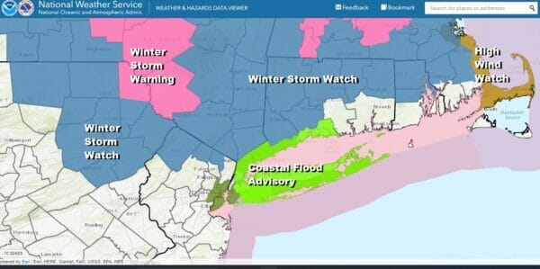
The first Winter Storm Warnings are up from Northeast Pennsylvania to the Catskills and points northward. Also the National Weather Service has extended Winter Storm Watches to cover Southern Connecticut except the southeast. Winter Storm Watches have also been extended to cover Southeast New England except near the coast and Cape Cod. Areas to the south in the rest of Northern New Jersey, NYC and Long Island are not under a watch at this time but it is likely that a portion of this zone could go under a Winter Weather Advisory sometime Monday. Nothing of consequence other than some rain will occur later tonight and the first snows will develop inland during Monday night and continue on Tuesday, probably working their way southward toward the coast.
SATELLITE

WEATHER RADAR

This evening we are seeing the leading edge of some light rain approaching as we have both southern and northern energy approaching. This means that tonight will be cloudy with some patchy light rain. Some wet snow could be in the mix well inland but it likely won’t amount to much. Most lows tonight will be in the 30s.
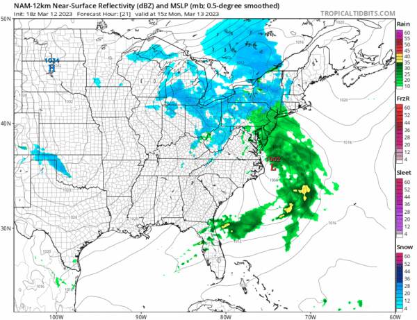
Most of the area will see rain Monday as low pressure moves from North Carolina northeastward. It is not until Monday night when we begin to see the effects of a strong upper air storm as that drives southeast from the Great Lakes to off the New Jersey coast during Tuesday. This will drag colder air southward and rain will change to wet snow late in the day Monday across the Catskills, the Upper Hudson Valley into Central New England. The changeover will slowly spread southward Monday night into Northern New Jersey, the Lower Hudson Valley and Conecticut and finally reach the coast sometime Tuesday morning.
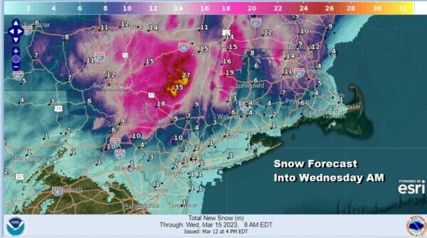
There are a few things we can see with reasonable confidence. First is that areas along and north of Route 84 will see a foot or more of snow but amounts are going to vary based on elevation. There will be a shadow effect in areas east of the Hudson River as well as in the Connecticut River Valley which is why you see amounts go down somewhat in those areas while they are much higher on either side. Further south as we near the coast it will be about elevation and intensity and that will drive accumulations that will be either be on colder surfaces only or on roads as well. Amounts go down as you head south near the coast. Where those final numbers wind up will depend on the track of the upper air storm. If the upper air storm tracks further south, say Southern New Jersey or Delaware Bay, we could see heavier amounts near the coast as well though the one foot plus amounts will likely be further inland regardless.
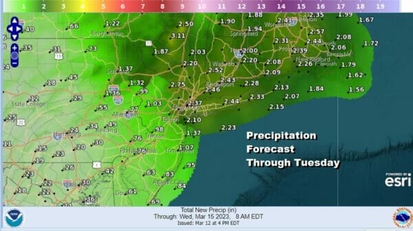
Total precipitation amounts will be substantial on the order of 1 to 2 inches especially from NYC and Northern New Jersey north and east with some amounts approaching 2.50 inches or more. This could be a combination of rain and snow. Strong winds will occur along the coast and they will start to gust to 30 to 40 mph later Tuesday into Wednesday as the storm begins to slowly pull away to the northeast. Most of this will come to an end sometime Tuesday night or early Wednesday morning and weather conditions will improve after that. PLEASE NOTE THAT THERE IS STILL SOME VOLATILITY IN THE FORECAST OUTLOOK SO EXPECT MORE CHANGES IN THE FORECAST MONDAY
BE SURE TO DOWNLOAD THE FREE METEOROLOGIST JOE CIOFFI WEATHER APP &
ANGRY BEN’S FREE WEATHER APP “THE ANGRY WEATHERMAN!
MANY THANKS TO TROPICAL TIDBITS & F5 WEATHER FOR THE USE OF MAPS
Please note that with regards to any severe weather, tropical storms, or hurricanes, should a storm be threatening, please consult your local National Weather Service office or your local government officials about what action you should be taking to protect life and property.


