First Storm Stays South But A Second Storm Brings
Wind & Rain Wednesday Night & Thursday
A new work week begins and we continue to be dominated by a chilly air mass in Eastern Canada that has wedged its way down the east coast. Another cold morning with lows in the 30s and lower 40s will lead to highs today in the mid 50s. There should be a good deal of sunshine however as a storm system now moving through the Deep South and Southeast US takes a track east northeast and offshore. Even the high clouds will stay mainly to the south today. Radars are on the quiet side for another day or so before we have to deal with any rain.
SATELLITE WITH LIGHTNING STRIKES
WEATHER RADAR
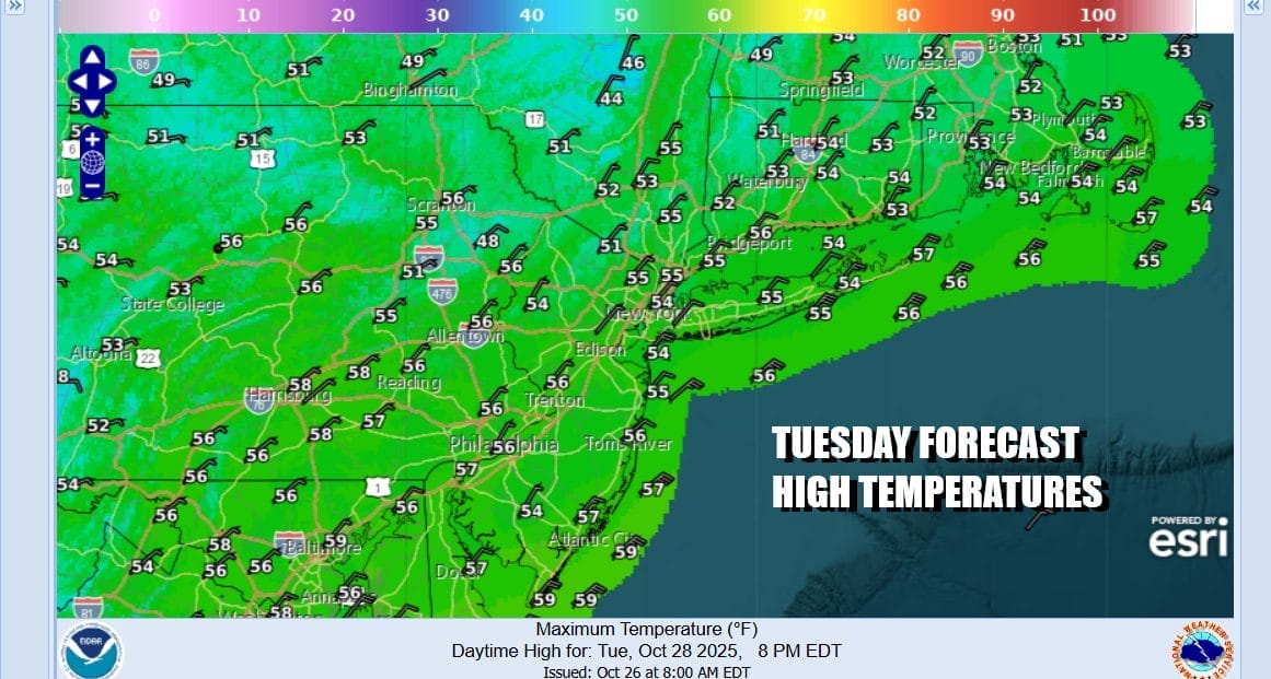
Another chilly night lies ahead with mainly clear skies. Most coastal and urban location lows will be in the lower 40s but cold spots as well as inland areas will be in the low and middle 30s and a few of the coldest spots well inland will be in the 20s. Tuesday will be another chilly but mainly sunny day with an northeast wind. Most highs will reach the middle 50s, a little lower to the north, a little higher to the south.
Weather conditions will deteriorate Wednesday as clouds roll in. The flow becomes more onshore bringing in low level moisture. Some spotty light rain or drizzle can’t be ruled out. Another storm system will be diving southeastward into the Tennessee Valley Wednesday and then making the turn northward up the Appalachians Wednesday night and Thursday.
The lows strengthens and the gradient tightens up so look for winds to pick up Wednesday to some extent and then more so Wednesday night and Thursday as the low passes to the west and a weather front lifts northeastward up the East Coast. This system has energy to it so expect rain to develop Wednesday night that could become heavy at times going into Thursday. We might also have a few thunderstorms in the mix as the front lifts up the coast. Temperatures both Wednesday and Thursday will be in the 50s while all this is going on. Winds will be from the southeast and could gust to gale force along the coast. As far as coastal flooding risks go, we are in a good place with regards to the moon phase which is a plus. At the moment we expect the risk for minor to some areas of moderate coastal flooding at high tide to be on the table Wednesday night and Thursday until the front moves north and winds shift to the west late Thursday. Weather conditions should improve Friday. Hurricane Melissa which is a category 5 hurricane going into Jamaica tonight and Eastern Cuba Tuesday, will move through the Southeast Bahamas Tuesday night into Wednesday and then to Bermuda Thursday. It is not a risk to the US East Coast in any way shape or form.
BE SURE TO DOWNLOAD THE FREE METEOROLOGIST JOE CIOFFI WEATHER APP &
ANGRY BEN’S FREE WEATHER APP “THE ANGRY WEATHERMAN!
MANY THANKS TO TROPICAL TIDBITS FOR THE USE OF MAPS
Please note that with regards to any severe weather, tropical storms, or hurricanes, should a storm be threatening, please consult your local National Weather Service office or your local government officials about what action you should be taking to protect life and property.