DOWNLOAD MY NEW FREE JOESTRADAMUS WEATHER APP FOR ALL DEVICES
THE APP IS ABSOLUTELY FREE TO ALL BUT CONSIDERING SUBSCRIBING TO PATREON FOR A WEATHER EXPERIENCE FREE OF ADS, EXCLUSIVE VIDEOS FOR MEMBERS ONLY AND MUCH MORE…STARTS AT $2 A MONTH..MESSAGE ME AT ANY TIME
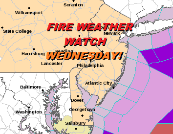
Fire Weather Watch Wednesday New Jersey Eastern Pennsylvania

New Castle-Kent-Inland Sussex-Delaware Beaches-Sussex-Warren-
Morris-Hunterdon-Somerset-Middlesex-Western Monmouth-
Eastern Monmouth-Mercer-Salem-Gloucester-Camden-
Northwestern Burlington-Ocean-Cumberland-Atlantic-Cape May-
Atlantic Coastal Cape May-Coastal Atlantic-Coastal Ocean-
Southeastern Burlington-Carbon-Monroe-Berks-Lehigh-Northampton-
Delaware-Philadelphia-Western Chester-Eastern Chester-
Western Montgomery-Eastern Montgomery-Upper Bucks-Lower Bucks-
302 PM EDT Tue Apr 2 2019
...FIRE WEATHER WATCH IN EFFECT FROM WEDNESDAY MORNING THROUGH
WEDNESDAY EVENING…
The National Weather Service in Mount Holly has issued a Fire
Weather Watch. It is in effect from Wednesday morning through
Wednesday evening.
* AFFECTED AREA…The Poconos, the Lehigh Valley, Berks County
and southeastern Pennsylvania. Also, northwestern, central and
southern New Jersey and the entire state of Delaware.
* TIMING…From 10:00 AM until 9:00 PM Wednesday.
* WINDS…West 20 to 25 MPH with gusts of 30 to 35 MPH.
* RELATIVE HUMIDITY…Dropping into the 20 to 30 percent range.
* TEMPERATURES…Highs mainly in the 60s.
* IMPACTS…Gusty winds and very dry air will create conditions
that may promote the rapid spread of wildfires.
PRECAUTIONARY/PREPAREDNESS ACTIONS…
A Fire Weather Watch means that critical fire weather conditions
are forecast to occur due to a combination of strong winds, low
relative humidity and dry fuels. A Red Flag Warning may be issued.
For more information about wildfire danger, burn restrictions,
and wildfire prevention and education, please visit your state
forestry or environmental protection website.
ALSO FOR NORTHEASTERN NEW JERSEY
Western Passaic-Eastern Passaic-Hudson-Western Bergen-
Eastern Bergen-Western Essex-Eastern Essex-Western Union-
Eastern Union-
344 PM EDT Tue Apr 2 2019
…FIRE WEATHER WATCH IN EFFECT FROM WEDNESDAY MORNING THROUGH
WEDNESDAY EVENING FOR NORTHEAST NEW JERSEY…
The National Weather Service in Upton has issued a Fire Weather
Watch for northeast New Jersey, which is in effect from Wednesday
morning through Wednesday evening.
* Affected Area…Passaic, Bergen, Union, Essex, Hudson Counties.
* Timing…Late morning Wednesday through the afternoon and into
the evening.
* Winds…West 15 to 25 mph with gusts up to 40 mph.
* Relative Humidity…As low as 19 percent.
* Impacts…Gusty winds and very dry air will create conditions
that may promote the rapid spread of wildfires.
MANY THANKS TO TROPICAL TIDBITS FOR THE USE OF MAPS
Please note that with regards to any tropical storms or hurricanes, should a storm be threatening, please consult your local National Weather Service office or your local government officials about what action you should be taking to protect life and property.