
DOWNLOAD MY NEW FREE JOESTRADAMUS WEATHER APP FOR ALL DEVICES
THE APP IS ABSOLUTELY FREE TO ALL BUT CONSIDERING SUBSCRIBING TO PATREON FOR A WEATHER EXPERIENCE FREE OF ADS, EXCLUSIVE VIDEOS FOR MEMBERS ONLY AND MUCH MORE…STARTS AT $2 A MONTH..MESSAGE ME AT ANY TIME
Fire Weather Risk Wind Advisories
On the satellite loop this morning on the upper right we can see the exiting major storm which has really developed into a powerful cyclone. This of course is driving our weather today with lots of sunshine, very low dew points, and very gusty winds. Given the dry conditions and all the dead brush accumulated over the winter the table is set for fire risk and we have red flag warnings and wind advisories in effect for many areas from the Hudson Valley to New Jersey and Pennsylvania. Winds will be gusting to 40 mph or more at times this afternoon.
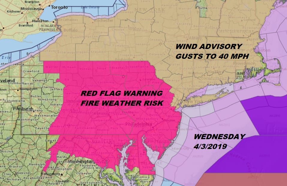
RED FLAG WARNING IN EFFECT FROM NOON TODAY TO 11 PM EDT THIS
EVENING FOR THE LOWER HUDSON VALLEY…
The National Weather Service in Upton has issued a Red Flag
Warning, which is in effect from noon today to 11 PM EDT this
evening.
* Affected Area…Orange, Putnam, Rockland, and Westchester
counties in southeast New York.
* Timing…This afternoon and evening.
* Winds…West 15 to 25 mph with gusts 45 to 50 mph.
* Relative Humidity…As low as 19 percent.
* Impacts…Rapid fire spread possible if ignition occurs.
PRECAUTIONARY/PREPAREDNESS ACTIONS…
A Red Flag Warning means that critical fire weather conditions
are expected or occurring. A combination of strong winds, low
relative humidity, and dry fuels will create a significantly
elevated fire growth potential.
RED FLAG WARNING IN EFFECT FROM 10 AM THIS MORNING TO 9 PM EDT
THIS EVENING FOR STRONG WINDS AND LOW RELATIVE HUMIDITY FOR
EASTERN PENNSYLVANIA, MOST OF NEW JERSEY, AND DELAWARE…
The National Weather Service in Mount Holly has issued a Red Flag
Warning for the potential of enhanced fire spread, which is in
effect from 10 AM this morning to 9 PM EDT this evening. The Fire
Weather Watch is no longer in effect.
* AFFECTED AREA…The Poconos, Lehigh Valley, Berks County, and
southeastern Pennsylvania. Also northwestern, central, and
southern New Jersey and the entire state of Delaware.
* TIMING…From 10:00 AM until 9:00 PM Wednesday.
* WINDS…West 15 to 25 mph with gusts up to 40 mph.
* RELATIVE HUMIDITY…Dropping into the 20 to 30 percent range.
* TEMPERATURES…Highs mainly in the 60s, with 50s in the Poconos
and far northwest New Jersey.
* IMPACTS…Gusty winds and very dry air will create conditions
that may promote the rapid spread of wildfires.
SATELLITE

REGIONAL RADAR

At least we will see a rather warm day with temperatures this afternoon topping out in the low to mid 60s. It would be really nice if it weren’t for the wind. Skies will be clear tonight with lows in the 30s. The we have another nice day on Thursday with much less wind, sunshine and late day arriving clouds with highs only back into the 50s. We are going to be setting the table for an onshore flow on Friday which will make for a raw and rainy day. Temperatures Friday will not be out of the 40s.
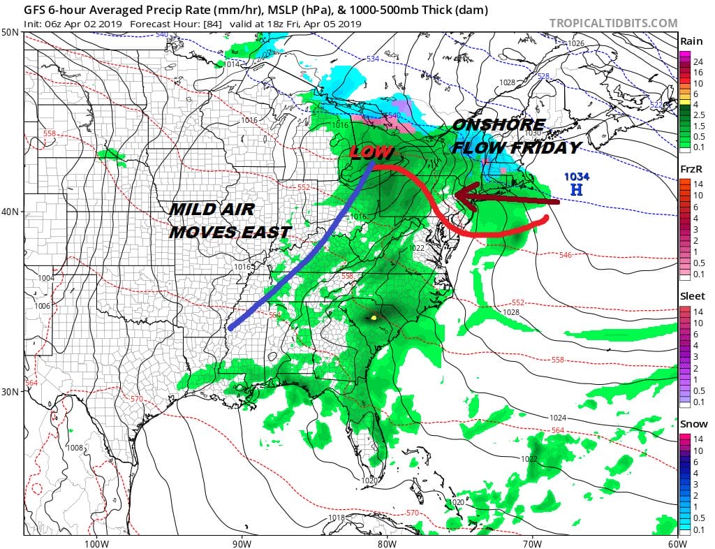
When it comes to the weekend the question will be the relaxation of the onshore flow which it will do to an extent. We will play it from the positive side for now and go for clouds giving way to some sunshine on Saturday with highs in the 60s and sunshine giving way to arriving clouds on Sunday with highs in the upper 50s and lower 60s.

The next weather system follows Friday’s rather quickly with the seemingly endless stream of Pacific energy coming into the west. Sunday night into Monday it will be back to clouds and rain as low pressure heads to Great Lakes and a warm front is pinned down to our south. This is going to be a slow battle early next week as blocking develops over Greenland and slows everything down to a crawl. This could bring some typical spring gloom for awhile. We will look at the impact of blocking later today.
MANY THANKS TO TROPICAL TIDBITS FOR THE USE OF MAPS
Please note that with regards to any tropical storms or hurricanes, should a storm be threatening, please consult your local National Weather Service office or your local government officials about what action you should be taking to protect life and property.


