
February Volatility Continues

One of the things that always gets me is how the models could show a deep low near Chicago 10 days out and it won’t very 60 miles from that position. When reality comes guess what? The low is near Chicago. But put a low anywhere near the east coast on day 10 and it could wind up anywhere within a 500 mile radius! Such is life of a forecaster. The storm heading for the Great Lakes 6 days ago is heading pretty much where the weather models have been saying. It makes our forecast fairly straight forward in a sense because we know that means rain for us and it won’t surprise me if it gets to 60 on Wednesday ahead of the cold front.
All that said the pattern going foward continues to display lots of volatility that really began back at the beginning of January. I would suggest everyone approach this along the same lines. Unlike the last 2 winters where the pattern just locked in and you could just sit there and watch storms play out the same way, the forecast approach this winter has been different. The Blizzard of 2016 was one of many results governed by the extreme nature of the jet stream pattern and the strong El Nino.
February Volatility Continues GFS Canadian & European Models

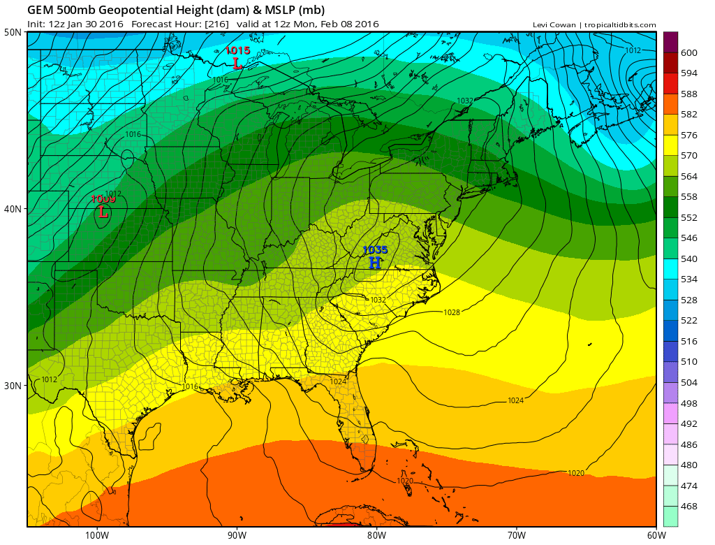
Just take a look at the models for day 9. Two models have nothing and the European has a bomb off the east coast. You would think that they could at least resemble each other. What is the European seeing that the other’s don’t?
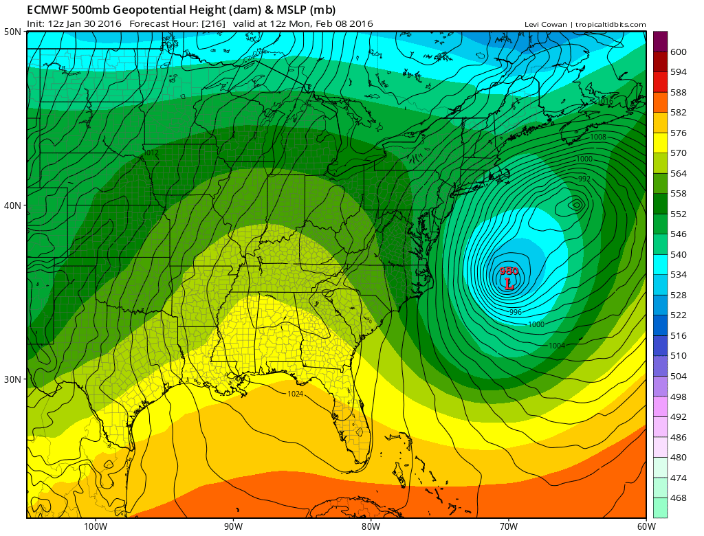
February Volatility Continues European Day 8

The European keys on southern stream energy that the other models either minor out, or don’t see at all. The GFS doesn’t seem to see anything there. The Canadian has some hints there but can’t act on it so it goes along its merry way.
February Volatility Continues GFS & Canadian Day 8

We have to go back to day 6 on the European to see where this is coming from. The model shows something coming into the west and then dropping down the Rockies (sound familiar?) before it begins to interact with the polar vortex to the north.
February Volatility Continues European Day 6

At this point we need to see some model consistency. Obviously the vast model differences lead us to be agnostic about this for the time being. The fact the European has it gives it an edge based on its longer range outperformance but remember the European model is not perfect. So for now we wait to see what models show us over the next several days before we start taking this seriously.
UPDATE ON POLAR VORTEX SPLIT
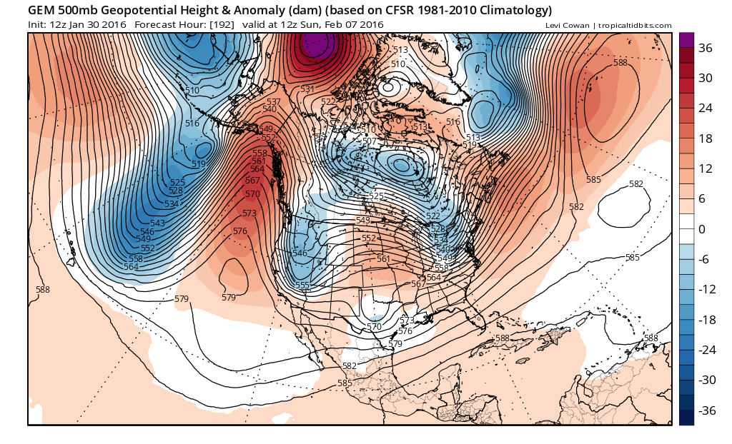
Yesterday on my JOESTRADAMUS post i wrote about the fact that the GFS was splitting the polar vortex at the highest levels of the atmosphere which would have long term implications on colder weather here in the east. The issue would be that a split in the vortex would mean cross polar flow and prolonged cold. Models since than have backed away from that idea though it would still mean invasions of cold air masses. But it would be a continuation of what we saw in January being that they would be more transient in nature. Here also we defer to more runs to see where this is going. I think the bottom line is that the pattern for the winter that has been established is volatility with wide swings. For now we continue with that idea going into the next several weeks until something shows us otherwise.
Its going to be a fun and challenging month ahead.
NATIONAL WEATHER SERVICE SNOW FORECASTS
LATEST JOESTRADAMUS ON THE LONG RANGE
Weather App

Winter is here! Don’t be without Meteorologist Joe Cioffi’s weather app. It is a complete weather app to suit your forecast needs. All the weather information you need is right on your phone. Android or I-phone, use it to keep track of all the latest weather information and forecasts. This weather app is also free of advertising so you don’t have to worry about security issues with your device. An accurate forecast and no worries that your device is being compromised.
Use it in conjunction with my website and my facebook and twitterand you have complete weather coverage of all the latest weather and the long range outlook. The website has been redone and upgraded. Its easy to use and everything is archived so you can see how well Joe does or doesn’t do when it comes to forecasts and outlooks.
Just click on the google play button or the apple store button on the sidebar for my app which is onMy Weather Concierge. Download the app for free. Subscribe to my forecasts on an ad free environment for just 99 cents a month.
Get my forecasts in the palm of your hand for less than the cost of a cup of Joe!

![]()