Father’s Day Weekend In The Land of Gloom & Doom
But Sunday Will Be Better Than Saturday
We have seen so many weekends in a row since Mid March where it has rained on at least one of the two weekend days and this weekend is no different. It looks like Sunday Father’s Day will actually be the better of the two weekend days but we do have to sacrifice today. We have cloudy skies and overnight rain that moved to the north of the coast is in the process of sinking back southward as a wave of low pressure moves offshore New Jersey and slides slowly eastward.
Eventually that rain will slide offshore late today. Until then it is a gloom and doom cloudy day with rain around and a flow of air from the east off the ocean. Temperatures today will not get out of the 60s in most places. Areas in South Jersey and points southward could see highs in the lower 70s. Tonight will be a night of cloudy skies with some patchy light rain or just drizzle. Most lows will be in the 50s to near 60 degrees.
SATELLITE WITH LIGHTNING STRIKES
WEATHER RADAR
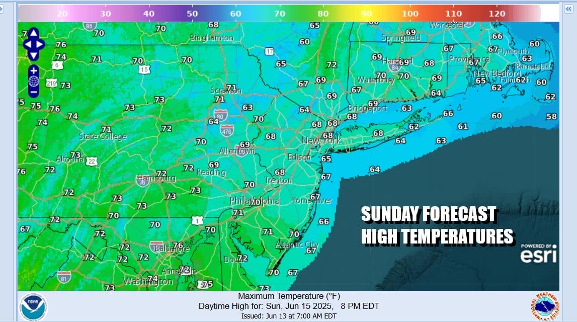
Sunday is Father’s Day and it should be the better of the two weekend days though it will by no means picture perfect. The onshore flow continues so there will be lots of clouds. However I would not be surprised if we see some brightening of skies or even a break or two of sun especially inland areas. Also while there might be some patchy very light rain or drizzle possible. I don’t think it lasts long and for most, Sunday will actually be a dry day.
As for temperatures, Sunday highs will be mostly in the 60s. The onshore flow does continue Sunday night and Monday so we will again have to deal with clouds especially during nighttime and morning hours. However the onshore flow should start to relax some Monday so we will call it mostly cloudy and allow for the possibility of some breaks of sun. Highs Monday will reach the upper 60s and lower 70s.
The onshore flow should start to relax somewhat Tuesday and that should allow for some sunshine to develop after some morning clouds. Tuesday highs will be in the mid to upper 70s as more sun means higher temperatures. Wednesday and Thursday we should see temperatures head back into the 80s as a southwest flow takes over. This will lead to chances for showers and thunderstorms inland Wednesday and a cold front stands to bring a higher chance for widespread shower & thunderstorm activity Thursday.
BE SURE TO DOWNLOAD THE FREE METEOROLOGIST JOE CIOFFI WEATHER APP &
ANGRY BEN’S FREE WEATHER APP “THE ANGRY WEATHERMAN!
MANY THANKS TO TROPICAL TIDBITS FOR THE USE OF MAPS
Please note that with regards to any severe weather, tropical storms, or hurricanes, should a storm be threatening, please consult your local National Weather Service office or your local government officials about what action you should be taking to protect life and property.