European Model verses GFS Model On Next Week
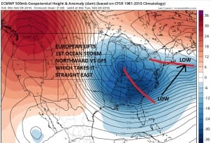
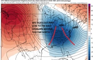
The European weather model last night continued consistent within itself from yesterday’s day run and it shows a different outcome from the GFS. The differences lie on how the models handle the lead system that moves off the southeast coast of the United States this weekend. The European lifts that storm northeastward as shown on the upper air maps below for day 5.
European Model verses GFS Model
How the European resolves the dilemma for next week is vastly different. The model takes the first storm off the southeast coast and it begins interacting with the very deep upper low in the Ohio Valley. The result is that the snow from the coastal system is pulled back westward to about New York City and the immediate coast.
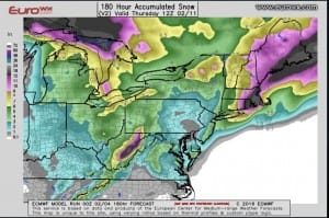
European Model verses GFS Model Euro Snowfall Forecast
Now bear in mind that this is the RUN TOTAL snowfall that includes 1 to 2 inches from tonight into Friday morning so you need to subtract that out. It would still bring back a few inches to just west of New York City and 6 plus from Central Long Island and Central Connecticut eastward. This run was also a little to the left of the prior run.
Now what does all this mean. Obviously we can’t even begin to determine how much value there is in the forecast until we figure out which model is correct on the behavior of the first ocean storm. If the the first storm this weekend becomes the primary feature then we need to see how it interacts with that upper air storm in the Ohio Valley. Will that upper low draw the coastal storm further left?
If the GFS is correct that the first storm gets ejected out as a weak system, then we have to see how it evolves the second system later Tuesday into Wednesday as that will then become the primary focus. The European’s solution of the first means no room for the second, while the GFS would mean exactly the opposite. Day runs will hopefully shed more light on this. In the meantime we have late tonight into Friday morning’s possible wet snowfall to contend with.
With regards to the next week here is the GFS overnight analysis with a little RGEM mixed in.
NATIONAL WEATHER SERVICE SNOW FORECASTS
LATEST JOESTRADAMUS ON THE LONG RANGE
Weather App
Winter is here! Don’t be without Meteorologist Joe Cioffi’s weather app. It is a complete weather app to suit your forecast needs. All the weather information you need is right on your phone. Android or I-phone, use it to keep track of all the latest weather information and forecasts. This weather app is also free of advertising so you don’t have to worry about security issues with your device. An accurate forecast and no worries that your device is being compromised.
Use it in conjunction with my website and my facebook and twitterand you have complete weather coverage of all the latest weather and the long range outlook. The website has been redone and upgraded. Its easy to use and everything is archived so you can see how well Joe does or doesn’t do when it comes to forecasts and outlooks.
Just click on the google play button or the apple store button on the sidebar for my app which is onMy Weather Concierge. Download the app for free. Subscribe to my forecasts on an ad free environment for just 99 cents a month.
Get my forecasts in the palm of your hand for less than the cost of a cup of Joe!


