
JOESTRADAMUS yesterday posted about what could be a developing blocking pattern as it appears that all the indicators regarding the “Atlantic Oscillation” are crashing into the negative. When this happens it means that we are going into a colder than normal and rather unstable weather pattern for the Northeast. This pattern has not been around for much of the last 3 winters except for brief moments. However there is more that one way to get cold and snowy during a winter and it doesn’t always require a Greenland block. It has been my experience that the European model seems to handle blocking much better than the GFS model so we will focus on last night’s European model run which has some action in the short term.
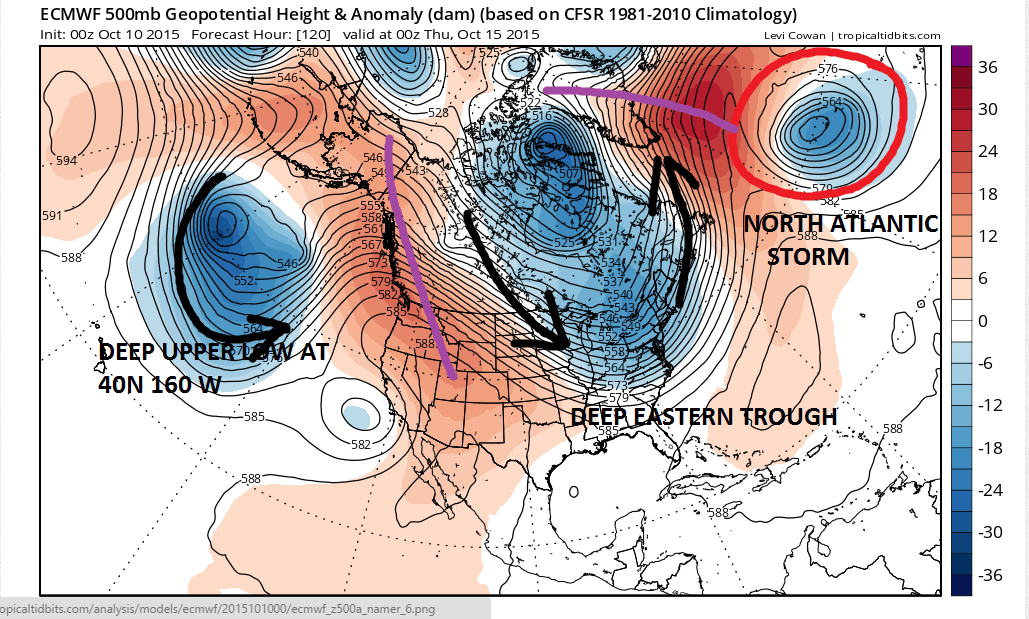
I have highlighted a few things to help you understand the flow of the atmosphere. Think of it as a series of gears of various sizes, each one interconnected with the other. There are 2 storms out there where the gears have gotten gummed up. We have a storm in the Pacific at 40N and 160 W..and we have a storm out in the North Atlantic. Both systems over time are going to have an strong say in how the next 2 weeks or longer play out. The Pacific storm is forecast to move east to 140W and closer to the California coast. The Atlantic Storm hardly moves at all.

This is what tends to happen in a blocking pattern. A blocking high develops north of the Atlantic low east of Greenland north of the North Atlantic Storm. As a result not only does the trough position in the east stay in the same spot but it gets amplified. This creates an interesting forecast situation because when ever you have a strong flow like this from Northern Canada to the Southeast US coast, not only does it mean colder than normal temperatures, but if there are disturbances embeded in that flow, anyone of them can amplify into something important.
Now lets look close up at the European 168 hr and you can see that this model picks up on 2 shortwaves coming down from the north.

The European develops this into a low that tracks across Southern Indiana to Southern Pennsylvania and then deepens offshore as it heads northeast to Nova Scotia. Given the colder than normal temperatures surface and aloft it is conceivable that this could be the seasons first snows for parts of upstate New York and well in the interior elevated areas of Central and Northern New England.

For us it would be a cold rain for late Friday and Friday night and then very chilly weather for next weekend. First frosts and maybe even first freezes are possible when this is all said and done. Now we should point out that the other 2 models show that the flow overwhelms and that the disturbances coming down are very weak and basically nothing happens except chilly and dry. Also the European earlier this week was trying to make something out of wave that was going to develop this morning off the New Jersey coast and we can see how that played out with mostly sunny skies today. The European is a better model but it isn’t perfect by any means. Still with blocking developing and the European’s tendency to do better in blocks, we may want to pay attention today’s run to see where things go. The European still has the trough position along the east coast by day 10 and the other models all showing blocky looks at least through day 10. One thing about the Canadian model I should mention. It develops the 50th or 60th tropical storm of the season (sarcasm) in the overnight run and we know how it loves to do this. This could be impacting how the model behaves as it goes out in time. All the models seem to be developing something in the northwest Caribbean late in the period which is where you would usually start to see development this late in the season. It appears we have interesting times ahead over the next several weeks. But at least this weekend continues to be just wonderful.
Be sure to download my app and subscribe to my specific forecasts for the New York New Jersey Eastern Pennsylvania and Southern New England. The app is free and a subscription is just 99 cents a month. There are no web ads and no security or tracking issues.