
European Model On Course For Snow This Weekend
With regards to the afternoon model runs, all the models remain remarkably consistent with the idea of a strong storm along the east coast this weekend and impacting the Middle Atlantic and Northeast. The devil is of course in the details but this is a summary break down.
EUROPEAN MODEL ON COURSE WHAT WE KNOW
At this point a storm impacting the Northeast & Middle Atlantic States will be happening beginning Friday night in southern areas of our region (Southern Pennsylvania, Southern New Jersey) and ending late Saturday night or early Sunday from southwest to northeast.
Coastal flooding and beach erosion will be a big issue for the coast from Delaware northward through Southern New England.
Where there is all snow there will probably be 1 foot plus amounts.
EUROPEAN MODEL ON COURSE WHAT WE DON’T KNOW
What we don’t know is where mixing issues or even rain shows up. Right now I think the biggest issue may be more that the storm winds up being too far south and not too far north and west.
Even with mixing issues in some areas, there still could be substantial snows given the magnitude of the precipitation forecast (1.00-1.50 inches of melted liquid).
Final track and strength. With this issue I am leaning on the European which offers the best solution that makes the most sense.
Now with regards to snowfall forecasts at this point it is way too early in the game for me to do anything that inspires any sort of confidence. I will be putting out a first call map possibly as early as Tuesday night but more than likely on Wednesday when we are within 72 hours of the beginning of any snow.
Now with regards to the European model today here is the set up.
EUROPEAN MODEL ON COURSE

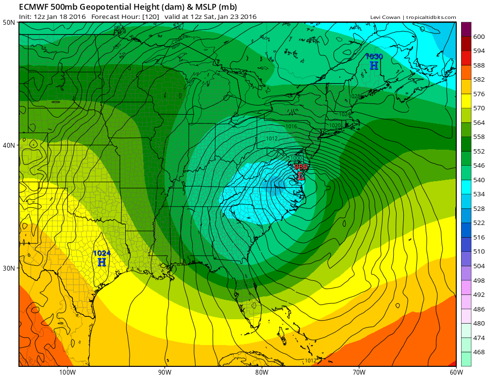
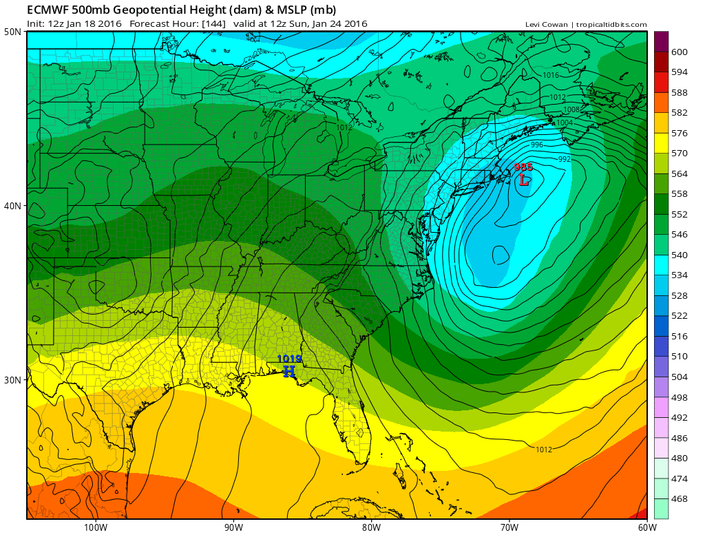
These maps are the European beginning Friday morning and taking us through Sunday morning. The upper air jet stream is shown with the surface map over it. It pretty much has the same idea with position shifts from run to run. Low pressure to Central Tennessee redevelops along or just off the Carolinas, intensifies into a major storm just off the Virginia coast, and then eventually redevelops to the northeast on Sunday. What continues to be remarkable is the relative consistency of the this model and the fact that all three models continue to show a major storm along the Northeast and Middle Atlantic coasts. In the few times it has done this in the past, the models wind up being (mostly) correct. I would lean away from the warmer solutions of the GFS and Canadian because I just think the northern jet stream is too strong to allow a northwest adjustment. Until the European shows this, I would lean toward its solution rather than the others. Even the other models would still be a big snowfall for much of the area. Either way we look at this, specifics at this point remain impossible to pinpoint.
EUROPEAN MODEL ON COURSE UPPER AIR

The polar jet across Southern Canada remains firm. This prevents the upper system from lifting to the west and instead lifts northeastward when it is along the coast. The mistake I believe the other models are making is that they weaken that polar jet slightly or at least enough to allow for a slightly more northwest track. This would have some implications for the coast from a practical forecast standpoint. It still might mean that the coast winds up with the same thing as inland spots in the end. It may just happen with some mix or rain in the middle. This is not a forecast issue for now. This is a forecast issue when we are inside 72 hours.
The bottom line at this point is that all the models are on course. The European to me has been the most consistent and insistent of the bunch with regards to track. It has not wavered much at all over the last 4 days or so. We will work out specifics and short term issues on Wednesday. And remember, this still could change. If the polar jet is weaker for some reason it opens the door to a more westward track. If the polar jet is stronger, it could wind up being further south and then we have to question how far north snow actually gets. These are the same battles we fight all the time. My point is I have no idea at this point in terms of specifics and amounts. No one really does.
OVERNIGHT GFS VIDEO ANALYSIS
NATIONAL WEATHER SERVICE SNOW FORECASTS
LATEST JOESTRADAMUS ON THE LONG RANGE
Weather App

Winter is here! Don’t be without Meteorologist Joe Cioffi’s weather app. It is a complete weather app to suit your forecast needs. All the weather information you need is right on your phone. Android or I-phone, use it to keep track of all the latest weather information and forecasts. This weather app is also free of advertising so you don’t have to worry about security issues with your device. An accurate forecast and no worries that your device is being compromised.
Use it in conjunction with my website and my facebook and twitterand you have complete weather coverage of all the latest weather and the long range outlook. The website has been redone and upgraded. Its easy to use and everything is archived so you can see how well Joe does or doesn’t do when it comes to forecasts and outlooks.
Just click on the google play button or the apple store button on the sidebar for my app which is onMy Weather Concierge. Download the app for free. Subscribe to my forecasts on an ad free environment for just 99 cents a month.
Get my forecasts in the palm of your hand for less than the cost of a cup of Joe!
![]()
![]()