European Model Gfs Model 2 Different Worlds Next Week

European Model Gfs Model 2 Different Worlds Next Week
Weather models are continuing to signal a flip in the weather pattern however it is never easy. The 2 major models go in different directions after the first half of next week. At least both agree that the ridge of high pressure in the east breaks down and a deep trough comes into the Eastern US early next week with some rain finally breaking the dry spell here on Tuesday.
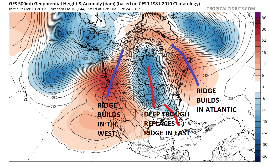
GFS MODEL TUESDAY OCTOBER 24 2017
EUROPEAN MODEL TUESDAY OCTOBER 24 2017
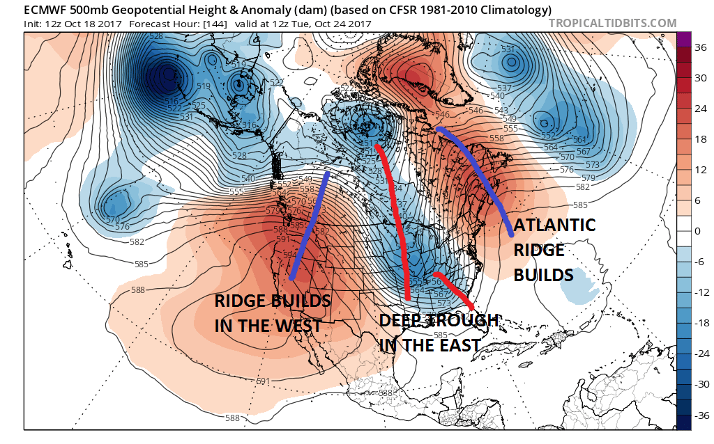
There are some subtle differences in the European model and the GFS model next Tuesday but the general idea here is the same. Deep trough swings into the Eastern US. Strong upper highs appear with one in the west and the other off the Atlantic coast. From here however the models diverge completely. The GFS eventually lifts out the trough in the East. It also has a completely different profile of what happens in the Atlantic
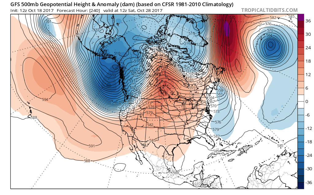
GFS MODEL NEXT SATURDAY OCTOBER 28, 2017
EUROPEAN MODEL SATURDAY OCTOBER 28

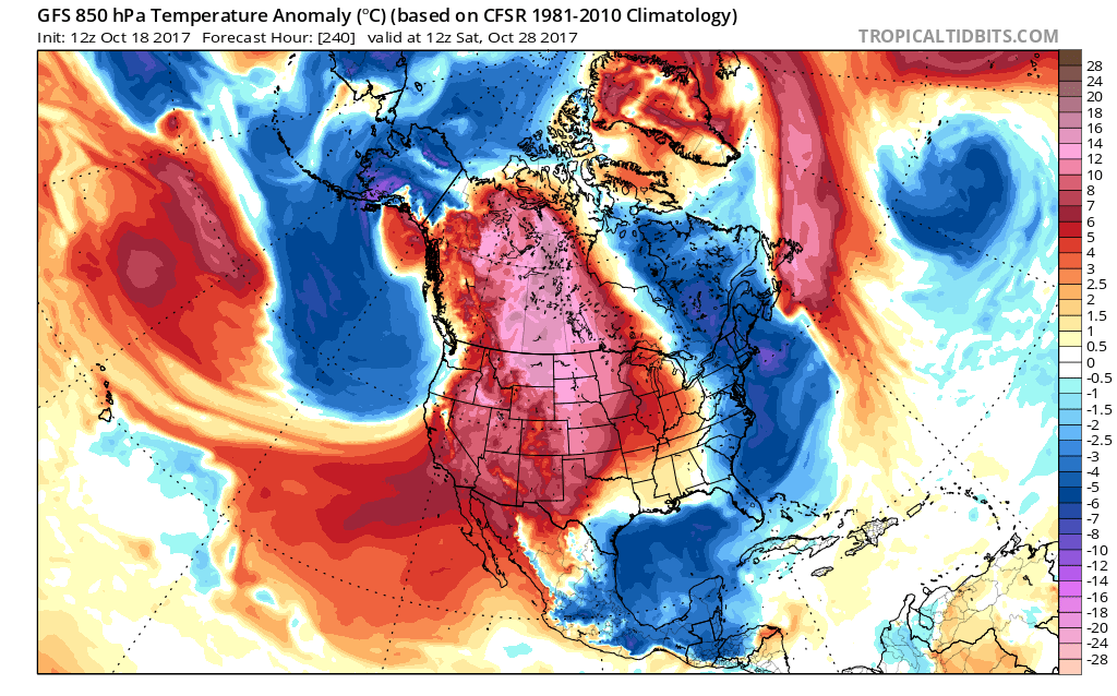
The GFS flattens out the Atlantic ridge completely as pressures lower over Greenland. The European builds and builds and builds the Atlantic Ridge to Greenland which then creates a second deep trough in the Eastern US late next week. This translates to a different temperature profile across the Eastern half of the US.
GFS MODEL TEMPERATURE ANOMALY SATURDAY OCTOBER 28
EUROPEAN MODEL TEMPERATURE ANOMALY SATURDAY OCTOBER 28
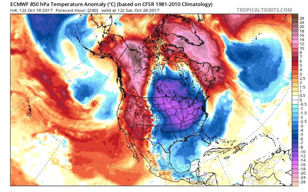
Which model will be right will hinge on the models view of the development of blocking in the North Atlantic. Ensemble members would lean toward the European idea vs the GFS but remember that weather models have predicted 20 of the last 2 blocking patterns. The volatility large enough in the long range under normal circumstances. It is multiplied tenfold when blocking is being signaled.

The bottom line at this point is that temperatures will continue to be warmer than average into Tuesday before the first shot of cool air arrives for the second half of next week. We should see some rain on Tuesday with a cold front and low pressure developing along it. The European would suggest a prolonged rain event into Wednesday. If the European is right the Upper Great Lakes back into Northern Minnesota could see their first snows late next week.
MANY THANKS TO TROPICAL TIDBITS FOR THE WONDERFUL USE OF THE MAPS

GET JOE A CIGAR IF YOU LIKE!
FiOS1 News Weather Forecast For Long Island
FiOS1 News Weather Forecast For New Jersey
FiOS1 News Weather Forecast For Hudson Valley
NATIONAL WEATHER SERVICE SNOW FORECASTS
LATEST JOESTRADAMUS ON THE LONG RANGE
Weather App

Don’t be without Meteorologist Joe Cioffi’s weather app. It is really a meteorologist app because you get my forecasts and my analysis and not some automated computer generated forecast based on the GFS model. This is why your app forecast changes every 6 hours. It is model driven with no human input at all. It gives you an icon, a temperature and no insight whatsoever.
It is a complete weather app to suit your forecast needs. All the weather information you need is right on your phone. Android or I-phone, use it to keep track of all the latest weather information and forecasts. This weather app is also free of advertising so you don’t have to worry about security issues with your device. An accurate forecast and no worries that your device is being compromised.
Use it in conjunction with my website and my facebook and twitter and you have complete weather coverage of all the latest weather and the long range outlook. The website has been redone and upgraded. Its easy to use and everything is archived so you can see how well Joe does or doesn’t do when it comes to forecasts and outlooks.
Just click on the google play button or the apple store button on the sidebar for my app which is on My Weather Concierge. Download the app for free. Subscribe to my forecasts on an ad free environment for just 99 cents a month.
Get my forecasts in the palm of your hand for less than the cost of a cup of Joe!