Euro Weather Model Weekend Outlook
Coastal Storm On Euro Model
GFS & Canadian Models Optimistic
This afternoon’s Euro weather model continues to trends of previous runs in showing a coastal storm for this weekend. However I want to point out right off the bat that the European weather model has done this several times over the last 6 weeks and has been WRONG on its perspective every single time.
Euro Weather Model Weekend Outlook Analysis
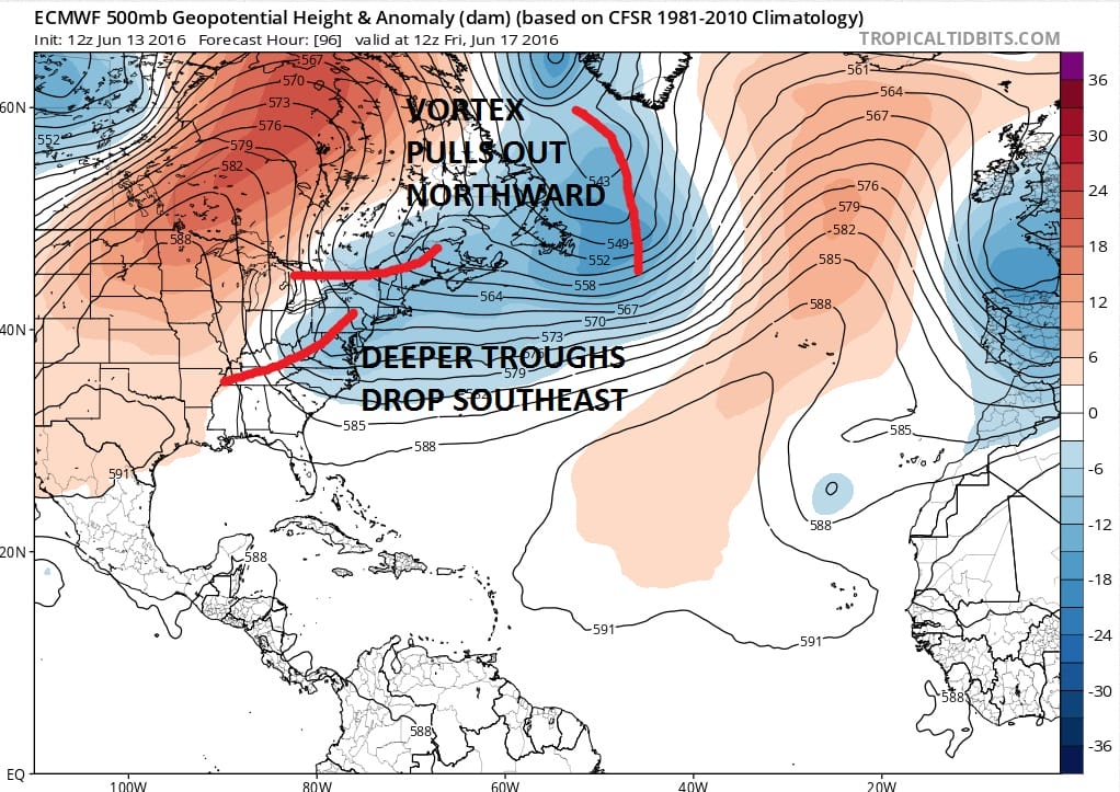
As I point out in my video, the key to the forecast lies in how the weather models handle the vortex in Eastern Canada. How that vortex pulls out will determine what happens to an upper air disturbance rotating around it.
Euro Weather Model Weekend Outlook
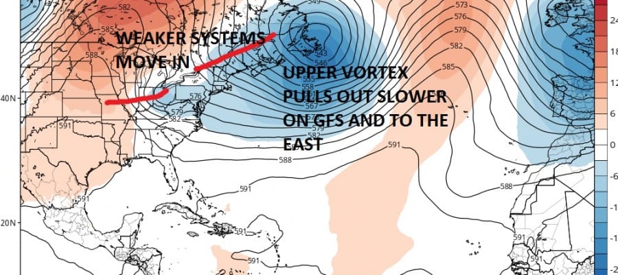
EURO UPPER AIR FRIDAY
Euro Weather Model Weekend Outlook
GFS UPPER AIR FRIDAY
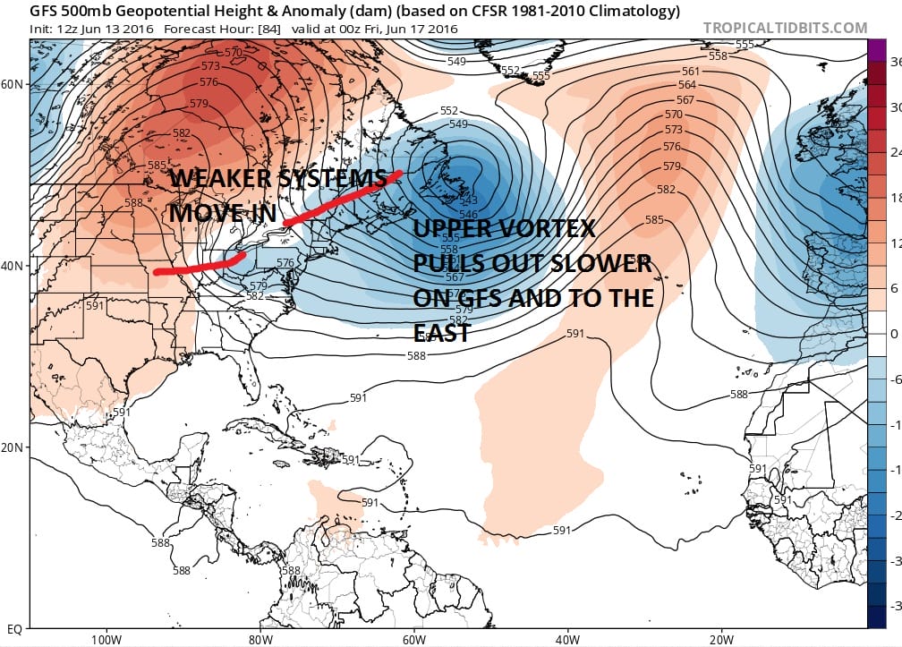
The two models on this afternoon’s model runs are distinctly different. The GFS takes the upper low intact and moves it out east northeast. This leaves the vortex influencing the weather in the Northeast US. The result is that the systems behind it are weaker and with much less room. The European on the other hand takes the vortex straight north and opens up the entire northeast to the troughs dropping southward. This creates the opportunity for another upper air storm to form along the east coast and a coastal surface low that goes with it. Since that vortex gets left behind, it would mean rain for much of the coming Fathers day weekend.
Euro Weather Model Weekend Outlook Father’s Day

Euro Weather Model Weekend Outlook GFS Father’s Day
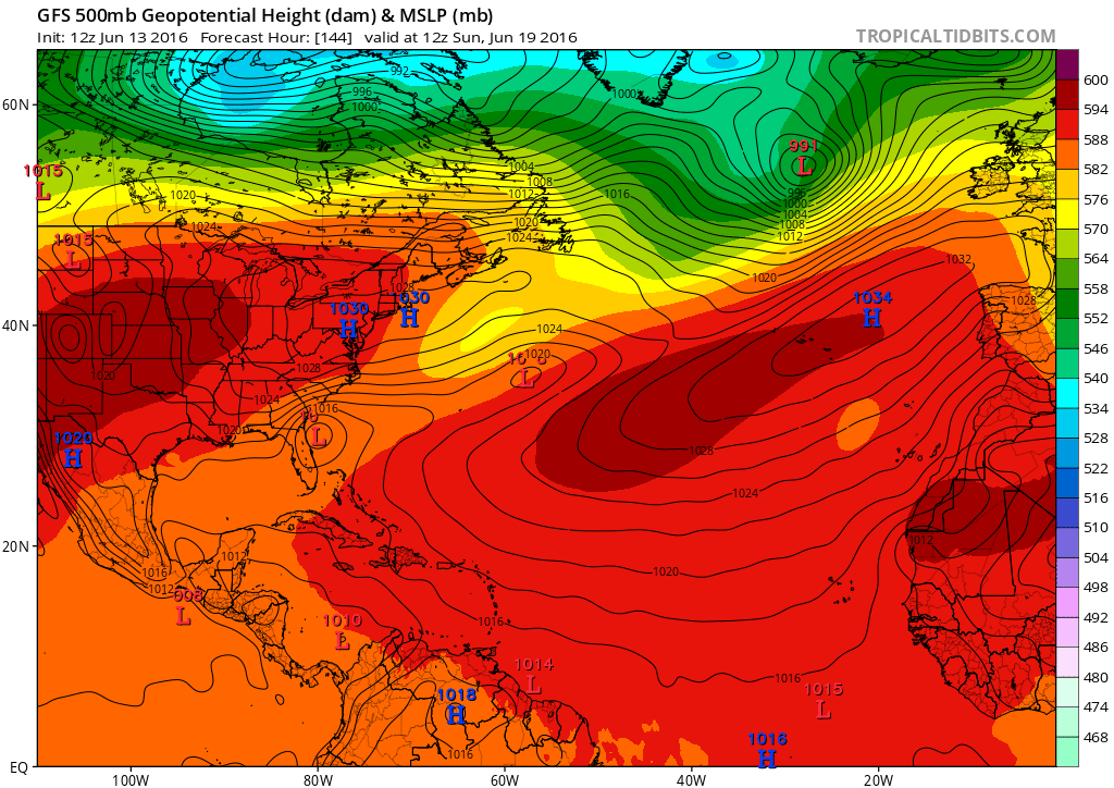
The Sunday picture on both models is different. The GFS is nice sunny and warm with highs in the 80s. The European is a soaking rain dismal and temperatures probably in the 60s. We continue to lean toward the optimistic outcome until proven otherwise. Also this is a cold core system on the European and the idea that it could become tropical is a bit far fetched.
JOESTRADAMUS HURRICANE SEASON GUEST FORECAST

MENTION JOE CIOFFI AND GET A 5% DISCOUNT
FiOS1 News Weather Forecast For Long Island
FiOS1 News Weather Forecast For New Jersey
FiOS1 News Weather Forecast For Hudson Valley
NATIONAL WEATHER SERVICE SNOW FORECASTS
LATEST JOESTRADAMUS ON THE LONG RANGE
Weather App

Don’t be without Meteorologist Joe Cioffi’s weather app. It is really a meteorologist app because you get my forecasts and my analysis and not some automated computer generated forecast based on the GFS model. This is why your app forecast changes every 6 hours. It is model driven with no human input at all. It gives you an icon, a temperature and no insight whatsoever.
It is a complete weather app to suit your forecast needs. All the weather information you need is right on your phone. Android or I-phone, use it to keep track of all the latest weather information and forecasts. This weather app is also free of advertising so you don’t have to worry about security issues with your device. An accurate forecast and no worries that your device is being compromised.
Use it in conjunction with my website and my facebook and twitter and you have complete weather coverage of all the latest weather and the long range outlook. The website has been redone and upgraded. Its easy to use and everything is archived so you can see how well Joe does or doesn’t do when it comes to forecasts and outlooks.
Just click on the google play button or the apple store button on the sidebar for my app which is on My Weather Concierge. Download the app for free. Subscribe to my forecasts on an ad free environment for just 99 cents a month.
Get my forecasts in the palm of your hand for less than the cost of a cup of Joe!
![]()

