
Euro Model Joestradamus Moves Slightly
![]()
With this afternoon’s run of the Euro model Joestradamus moves slightly thanks to his very open mind. There are issues here and there is nothing new but now that we are getting a little closer, the models seem to be converging on a similar idea. At this point we can reduce all the variables to a few very important ones. These variables will in the end be key to what kind of storm will form along the east coast and whether there will be impact to the coast.
Euro Model Joestradamus Moves Slightly JET STREAM MONDAY MORNING
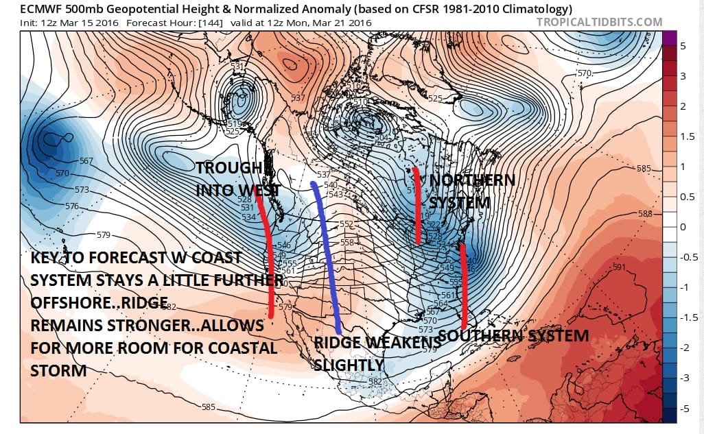
The map above is the European for Monday morning. First and foremost is timing. The European would time this storm out for later Sunday and Sunday night into Monday morning. This would mean that snow would fall at night so there is no sun angle issue. Secondly it will be cold enough especially aloft so this will be pretty much a snow or nothing event except maybe at the very beginning when it could start off as rain.
The more important variables however lie with the energy that is running around and the timing of the energy. The biggest and most important factor lies in the west. We have a strong ridge in the west 24 hours earlier. That ridge is drawn in purple. That ridge moves slightly eastward and weakens a bit because a disturbance moves into the west coast. This impacts the system in the east by forcing the trough position a little further east. It is further east enough so that the coastal lows develops offshore by 100 or more miles off North Carolina and then tracks east northeast from there. If that west coast trough is just a little slower it could enhance the ridge to its east slightly. That in turn would allow the east trough to be a little deeper and a little further left.
Another key will be the system in the northern stream and how it times out with that southern energy. You have to strike the delicate balance between having it close enough to interact with the southern energy and draw it closer to the coast. Too much interaction and you wind up with with something tucked in too far west. Not enough and you wind up with the northern stream energy kicking the surface low out to sea.
Euro Model Joestradamus Moves Slightly SURFACE SUNDAY AND MONDAY MORNING

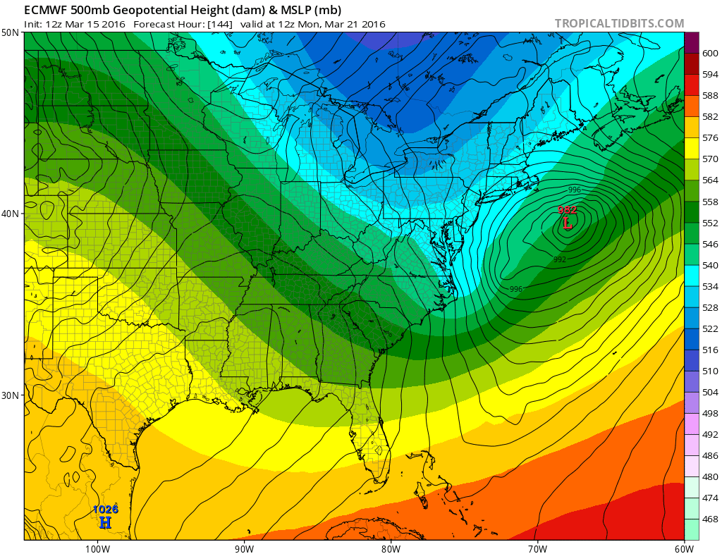
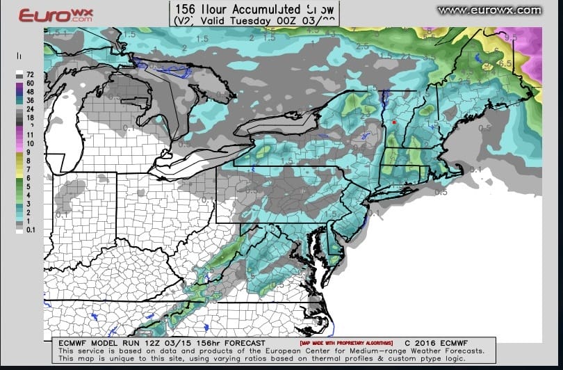
The Euro model track on this run grazes the coast with a quarter to a half inch of precipitation from Southern New Jersey through Southern New England. It also shows a half to three quarters of an inch for Central and Eastern Long Island and much of Southern New England. It is probably a little overdone but Im not going to argue that point right now. Whatever falls Sunday afternoon won’t stick because of the sun angle so it will be whatever precip falls between 6pm Sunday and 7am Monday that matters. This is why the Euro model snow map shows 1 to 3 inches of predicted snowfall. But that is a super short range issue.
Euro Model Joestradamus Moves Slightly EURO MODEL SNOWFALL FORECAST
In summary, I am inclined to believe that some snow is possible for Sunday night though I continue to lean against the idea of anything other than a minor event. We will have to watch the keys to the forecast closely over the next 2 days to see how models trend with all this. The winter experience with these systems would lead us to conclude that the outcome here will be no different than the others. Only in the blizzard did we have the surface low tucked in just far enough north and northwest to push heavy snow as far north as it got. The others were coastal grazers and right now, assuming that nothing changes with regard to strength and position of troughs and ridges, particularly the ones on the west, this one will be no different. But my mind is open and the door is now slightly ajar.
FiOS1 News Weather Forecast For Long Island
FiOS1 News Weather Forecast For New Jersey
FiOS1 News Weather Forecast For Hudson Valley
NATIONAL WEATHER SERVICE SNOW FORECASTS
LATEST JOESTRADAMUS ON THE LONG RANGE

NOMINATED FOR AN APPY AWARD FOR BEST WEATHER APP!!
Weather App

Don’t be without Meteorologist Joe Cioffi’s weather app. It is really a meteorologist app because you get my forecasts and my analysis and not some automated computer generated forecast based on the GFS model. This is why your app forecast changes every 6 hours. It is model driven with no human input at all. It gives you an icon, a temperature and no insight whatsoever.
It is a complete weather app to suit your forecast needs. All the weather information you need is right on your phone. Android or I-phone, use it to keep track of all the latest weather information and forecasts. This weather app is also free of advertising so you don’t have to worry about security issues with your device. An accurate forecast and no worries that your device is being compromised.
Use it in conjunction with my website and my facebook and twitter and you have complete weather coverage of all the latest weather and the long range outlook. The website has been redone and upgraded. Its easy to use and everything is archived so you can see how well Joe does or doesn’t do when it comes to forecasts and outlooks.
Just click on the google play button or the apple store button on the sidebar for my app which is on My Weather Concierge. Download the app for free. Subscribe to my forecasts on an ad free environment for just 99 cents a month.
Get my forecasts in the palm of your hand for less than the cost of a cup of Joe!
![]()
