
Euro Model Very Dynamic Next Week

MENTION JOE CIOFFI AND GET A 5% DISCOUNT
The Euro model is following the lines of the GFS model in showing a very dynamic pattern for next week however there are huge differences in the 2 models. Each goes a different way for the middle and latter part of next week. Earlier we wrote about the GFS and showing an intensifying low moving up the coast on Wednesday. The Euro model handles energy differently as it focuses more on the north than the south. It winds up with an ocean storm that develops late in the week and then sits around for a few days because it remains cut off from the main jet stream flow.
Euro Model Very Dynamic Next Week
GFS vs Euro Upper Air Wednesday/Thursday
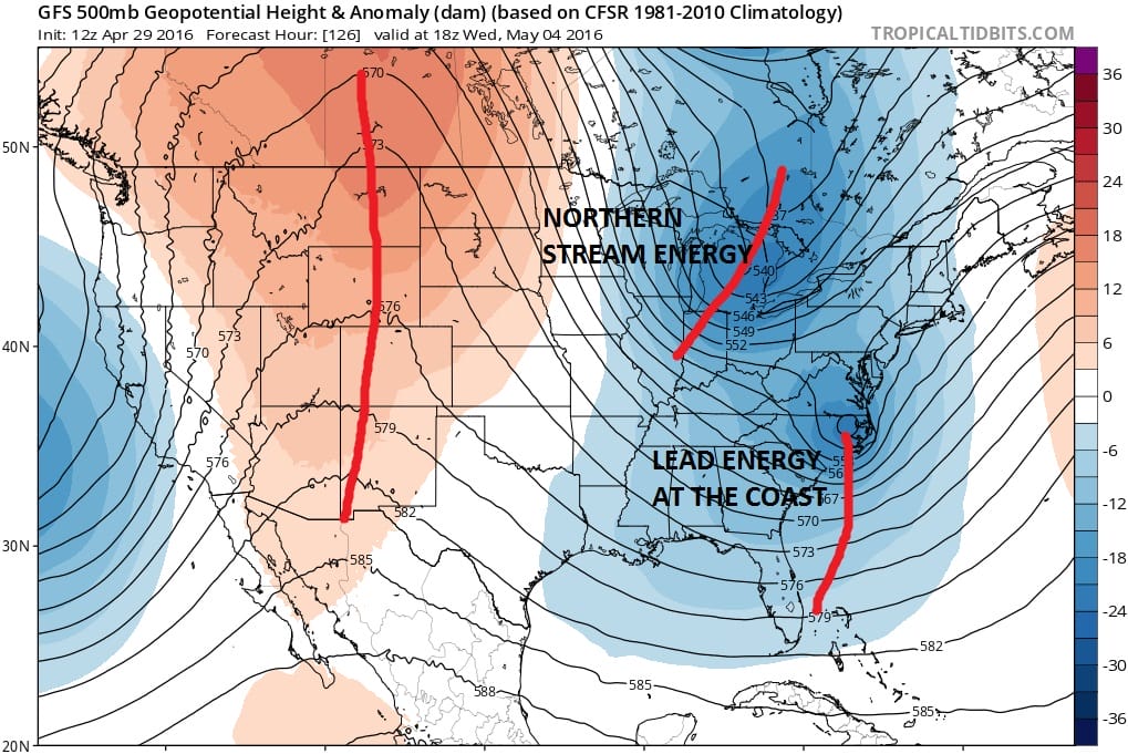
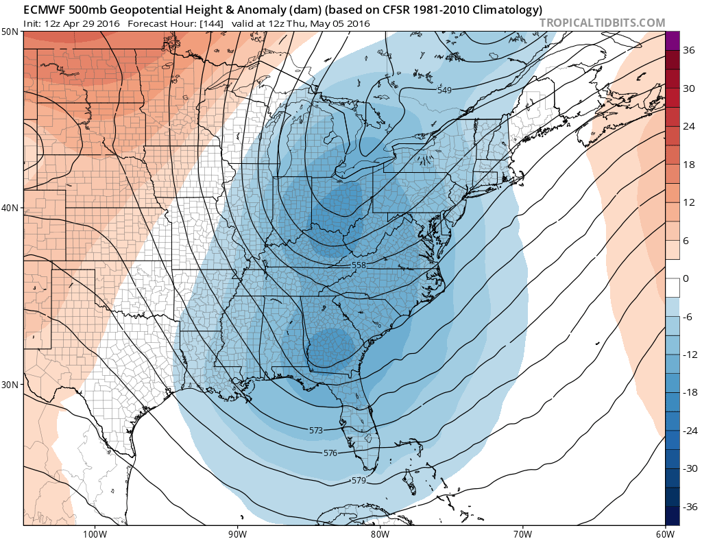
What the Euro model does is that it phases the two streams together unlike the above GFS which keeps them separate and progressive. The northern energy on the Euro model overwhelms the flow and dives southward. The result on the Euro is a huge upper air storm that cuts off from the main westerlies.
Euro Model Very Dynamic Next Week
Euro Upper Air Friday
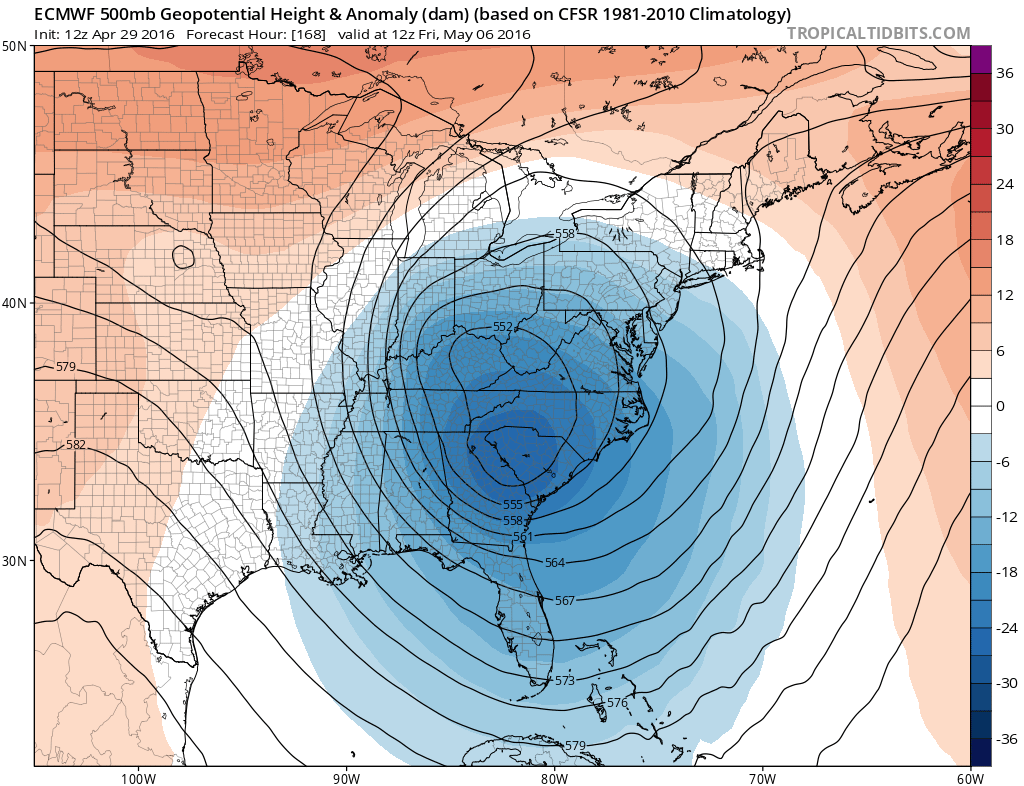
This Euro model solution is not inconsistent with what this model has been doing for the last several days. It has been showing this idea for awhile but each day it is a little different in how it handles all this. Models are signalling blocking strengthening late next week. That signal will have to be watched closely. The Euro would develop a coastal low and basically leave it along or just off the coast for 2 or 3 days. The question is whether blocking will be strong enough to cause this or will the more progressive GFS have the better idea.
LATEST WEATHER VIDEO ON EURO MODEL & GFS
FiOS1 News Weather Forecast For Long Island
FiOS1 News Weather Forecast For New Jersey
FiOS1 News Weather Forecast For Hudson Valley
NATIONAL WEATHER SERVICE SNOW FORECASTS
LATEST JOESTRADAMUS ON THE LONG RANGE

NOMINATED FOR AN APPY AWARD FOR BEST WEATHER APP!!
Weather App

Don’t be without Meteorologist Joe Cioffi’s weather app. It is really a meteorologist app because you get my forecasts and my analysis and not some automated computer generated forecast based on the GFS model. This is why your app forecast changes every 6 hours. It is model driven with no human input at all. It gives you an icon, a temperature and no insight whatsoever.
It is a complete weather app to suit your forecast needs. All the weather information you need is right on your phone. Android or I-phone, use it to keep track of all the latest weather information and forecasts. This weather app is also free of advertising so you don’t have to worry about security issues with your device. An accurate forecast and no worries that your device is being compromised.
Use it in conjunction with my website and my facebook and twitter and you have complete weather coverage of all the latest weather and the long range outlook. The website has been redone and upgraded. Its easy to use and everything is archived so you can see how well Joe does or doesn’t do when it comes to forecasts and outlooks.
Just click on the google play button or the apple store button on the sidebar for my app which is on My Weather Concierge. Download the app for free. Subscribe to my forecasts on an ad free environment for just 99 cents a month.
Get my forecasts in the palm of your hand for less than the cost of a cup of Joe!
![]()

