
We posted last week the first of what will be a series of snowcover maps of the Northwest back to Siberia as we begin to watch the Siberian snow growth. The indicator has some value in determining winter severity in the northeast and if it stood alone as an indicator (which it doesn’t) the faster the rate of growth, the higher the likelihood of a colder winter in the east. It did not work particularly well last year in that those who have worked on this reached the wrong conclusions regarding how the winter would evolve. In a sense they got it right for the wrong reasons.
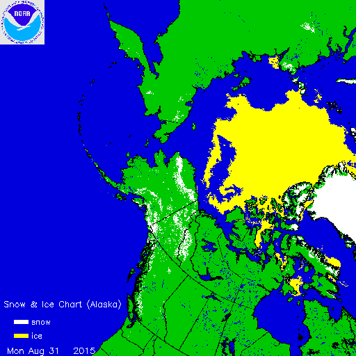
 So far the snow cover is minimal confined mainly to elevated areas. What is perhaps a little more interesting is the extent of ice cover. It is at its lowest level since records began in 1979. The ice won’t start growing for another few weeks but it will soon enough as the nights get longer and longer fairly rapidly at the northern latitudes.
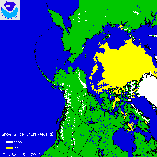
Earlier today I posted a blog post from Jeff Masters on this issue. It is worth the read. I will pull out this part of it. Read the entire piece for more.
The ice that’s managing to persist across the Arctic this summer doesn’t look especially healthy. Polar climate specialist Jennifer Francis (Rutgers University) calls out the warning signs conveyed in the most recent ice concentration image from NSIDC (see Figure 4, at right). “Much of the ice that’s left is either slushy, severely broken up, or covered in melt ponds,” Francis noted. Depletion is especially large on the Pacific side of the Arctic, she added, which recent work suggests may favor a severe winter in parts of eastern North America. Much research in the last few years by Francis and others has worked to draw connections between Arctic sea ice loss, high-latitude warming, and midlatitude winter weather. A new entry in this mini-discipline is a paper published last week in Nature Geoscience that links two modes of warm Arctic weather to subsequent winter cold downstream across East Asia and North America.
The power of this year’s still-strengthening El Niño event may be enough to swamp whatever influence the decline of Arctic sea ice might have on the upcoming winter across North America. Sea-surface temperatures (SSTs) are cooling over the western tropical Pacific in tandem with the building El Niño warmth over the eastern tropical Pacific. A number of studies (nicely summarized by Daniel Swain at California Weather Blog) suggest that the western-Pacific cooling will help lead to more storminess over the Gulf of Alaska, which in turn could finally erode the persistently warm SSTs and the “ridiculously resilient ridge” of high pressure that have prevailed in that area for most of the last two years. If so, a pathway will be carved for the classic El Niño signature of very mild winter temperatures across most of Canada and the northern United States, in line with the latest seasonal forecasts from NOAA. If, instead, we see a third consecutive winter of unusual cold across the U.S. Midwest and Northeast, it’ll be a strong sign that another player is onstage. Judah Cohen (Atmospheric and Environmental Research) bases his North American winter forecasts in part on the apparent relationship between low Arctic sea ice extent and cold Northern Hemisphere winters. “I really do think that this could be a very interesting winter and could be very informative on the interplay of tropical vs. Arctic forcing,” said Cohen in an email. “Can the Arctic, as a forcing agent of mid-latitude weather, finally step out out of the shadow of the tropics or not?”
In other words will the el nino over power the factors that could make for another severe winter in the east? Or are the other players on the stage going to overpower the el nino? We are extremely early in the game here with a long long way to go, many questions, and no way to reach any conclusions one way or another at this point. Be sure to link to the other stories to get a good feel for what is going on. Joestradamus reaches no conclusions.