
El Nino Beginning to Decline?
El Nino has no doubt been the dominating force in control of the weather world over the last number of weeks. It seems to be trumping any other indicator that forecasts change, and we see models that have been volatile in some runs showing large scale pattern changes in the long range only to back off over time. While there have been some changes in the look with regards to the awakening subtropical jet it has not changed the fact that the east continues under a big high pressure ridge pattern aloft with a deep trough in the west. In this scenario it can’t get cold or if it does it is only for a day or so.
Based on NOAA climate data it appears that the EL Nino has finally peaked and is at the very beginning of a long decline. We will look at the 2 regions of importance. The first is EL Nino 1+2 which is the area closest to South America and the equator. This is what is often referred to as an east based el nino. East based el ninos have the biggest impact for the east as it forces a ridge to build along the east coast keeping temperatures well above normal as we have seen throughout the month of November and for much of the autumn season.

The east based el nino peaked in july and then after declining set on a secondary lower peak which it has just made and now all models forecast a decline to occur into February. At that point you can see the models diverge but that occurs in the spring so we won’t worry about that. The point is that the decline takes place between now and March reducing the sea surface temperature anomoly (how much water temps are above normal) by more than half.
The second area is in the Central Pacific or El Nino 3+4. This too has peaked and models show a gradually decline here into the spring though the rate of decline is perhaps not as sharp. Central based el ninos feed the subtropical jet stream and send systems crashing into the west. They then find there way eastward. 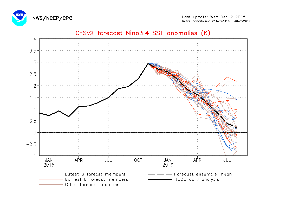
If (and its a big if) the central based el nino becomes more dominant and the east based el nino weakens faster, this should reduce the strong ridge in the east and shift it westward which would allow more cold air to move in to the east, or at least enough to bring temperatures back closer to normal. Everyone in the weather world that is a snow lover and cold weather lover has been posting about the SOI or the Southern Oscillation Index (think NAO but south!) crashing over the last few weeks. We have yet to see this translate to anything meaningful regarding a pattern change across northern regions but there is a considerable lag time with these sorts of things.
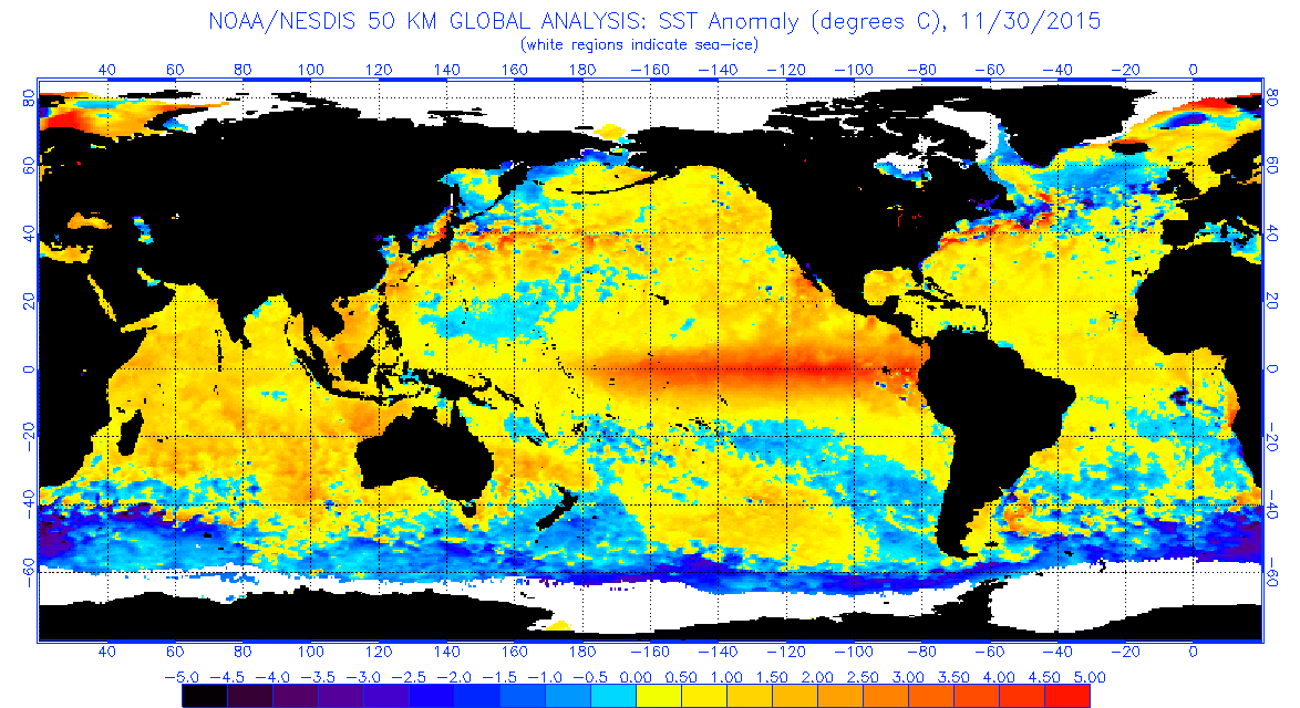
Now regarding the sea temperature anomalies across the globe several things stand out. Firstly the el nino is still there though from a month ago the extent and magnitude of the above normal area has gotten a little smaller. The northeast Pacific to the Gulf of Alaska remains warmer than normal so that anomaly from the last several years remains in place. The cold pool in the Atlantic is extending itself southwestward. This is important as in active NAO years, the cold pool migrates to off the northeast coast were temps still remain a bit above normal. We will of course continue to watch these trends. As to shorter term trends to look for, the NAO based on last night’s GFS ensemble model runs show the index trending down from strong positive to neutral over the next few weeks.

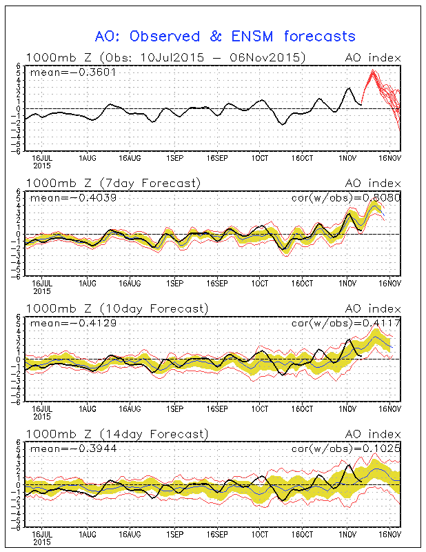
The Artic Oscillation which when negative displaces cold air southward is also forecast to move toward neutral or even slightly negative from the super positive position it reaches in a few days.
All of this just adds more mystery to all of this. I know snow lovers and winter cold lovers are shutting the windows and turning ovens on to release the gas and I would just say to you that no one has any real idea how this is going to wind up. Yes it could wind up being a lousy winter for you in the end. It is alot to ask for another winter of cold and snow which would basically make it 7 of the last 8. That is highly unusual and has never happened before. Sub par winters are the norm and maybe this will be one. On the other side is that we are seeing combinations of factors that we may not have seen before and that could lead to another outcome that has yet to play itself out. Last December if you recall was about 2 to 3 degrees above normal with very little snow especially for the coast. I will toss this out there. If December winds up being among the 10 warmest, records show that among the 10 warmest Decembers, not a single one of those winters produced above normal snowfall.
Be sure to watch me on FiOS1 News Long Island, New Jersey, Hudson Valley
CLIMATE MODELS WINTER FORECASTS ISSUED DECEMBER 1, 2015
SHORT TERM FORECAST NEW YORK NEW JERSEY CONNECTICUT PENNSYLVANIA
JOESTRADAMUS WINTER FORECAST 2015-2016