
DOWNLOAD MY NEW FREE JOESTRADAMUS WEATHER APP FOR ALL DEVICES
THE APP IS ABSOLUTELY FREE TO ALL BUT CONSIDERING SUBSCRIBING TO PATREON FOR A WEATHER EXPERIENCE FREE OF ADS, EXCLUSIVE VIDEOS FOR MEMBERS ONLY AND MUCH MORE…STARTS AT $2 A MONTH..MESSAGE ME AT ANY TIME
Early Spring Like Conditions (Gloom & Doom Part) Into Friday Colder Weekend
The day begins colder and the memory of 60s to near 70 degrees fades away today as we are going to be 25 degrees or more colder at the same time this afternoon. Such is an early sprnig like pattern with lots of temperature volatility. The last two days was the nice part (aside from the sea breeze at the coast). Now comes the gloom and doom part of spring. We have no cold air of consequence so it will be a matter of watching clouds increase and then see some rain move in late this afternoon into this evening. Temperatures in the 30s today will reach the low and middle 40s sometime this evening. and then just settle there overnight. We will see some rain. Colder areas well north and west of Route 84 could see a few hours of freezing rain before a change to rain occurs.
REGIONAL RADAR

The regional radar is beginning to pick up on rain to the west in Pennsylvania and Ohio moving eastward. We should see quiet conditions on the local radars until later this afternoon.
LOCAL RADAR NEW YORK CITY

LOCAL RADAR PHILADELPHIA


The first round of rain takes us through early Thursday morning. Then we wait for a warm front to push slowly northward. That means damp and dreary conditions Thursday even if it isn’t raining. Temperatures will be holding in the 40s until the warm front passes (or at least tries to pass) Thursday night with a cold front that follows Friday morning with a shower.
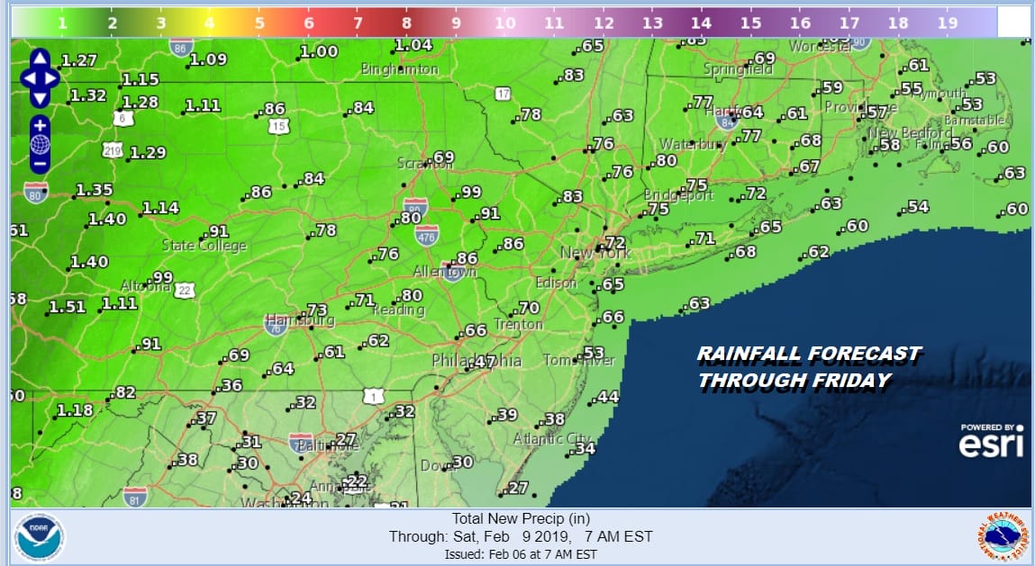
Rainfall amounts should be on the order of a half inch to at most an inch over the next day and a half. Later Friday some sunshine returns with highs in the 50s. A cold high from Canada builds in for the weekend with sunshine and temperatures just in the 30s and nights in the teens and lower 20s.
SNOW CHANCES NEXT WEEK
I think we are going to see something snow wise from the evolving weather pattern for next week. The pieces are all there on the weather maps and I’m still not quite sure exactly how this all plays. A front with perhaps a weak wave on it comes through Sunday night into Monday as the next high attempts to build in from Canada. That has a shot of leaving some accumulating snow on the order of a coating to an inch or 2. Then the more important pieces come out later Tuesday into Wednesday. Not much has changed since my long range post from yesterday.
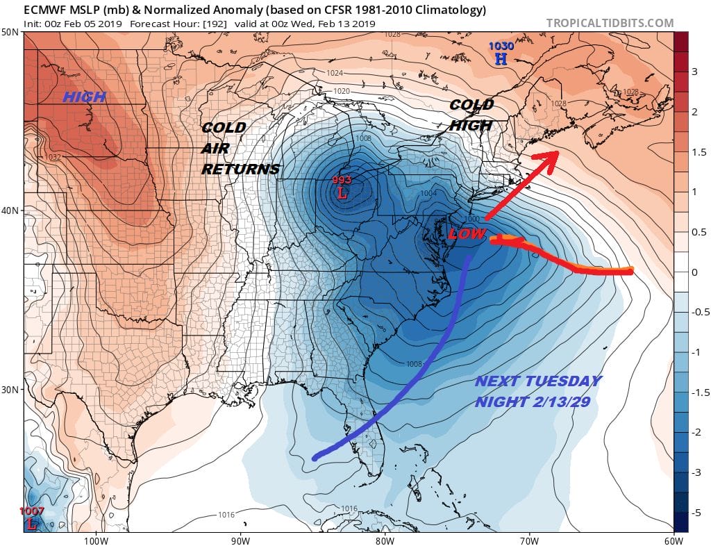
The map above is the European model from yesterday. This matches up to some degree with the overnight models as they shift back and forth. I will take a look at things later today. I’m not going to spend too much time on this now and have no energy left by the time this happens. It is still 5 to 7 days away. This afternoon I will give things another look.
There will be more extensive weather coverage on my weather platform on Patreon which is just $2 a month. Live stream on Patreon this morning at 9:30am
MANY THANKS TO TROPICAL TIDBITS FOR THE USE OF MAPS
Please note that with regards to any tropical storms or hurricanes, should a storm be threatening, please consult your local National Weather Service office or your local government officials about what action you should be taking to protect life and property.


