Drying Out Tonight Chance Snow Showers Wednesday Very Cold Thursday Friday
We will start to see the vast majority of Winter Weather Advisories and the Winter Storm Warnings discontinued as we move through the evening hours. It has been a miserable day all the way around with rain where it has been above freezing and some additional freezing rain in some areas where it is below freezing. Temperatures have changed very little since this morning.
Low pressure is slowly developing offshore and slowly moving away to the east which means the clearing of skies will be a slow process as well. Clouds extend back rather far to the west and without a wrapped up deepening low, it will be hard to get these clouds out of the way. That may actually be a plus in helping to keep temperatures from dropping too far too fast. Clouds should start to break up later this evening and temperatures will start to drop below freezing after 10 or 11pm. Perhaps we could get some drying to prevent any refreeze tonight. Use caution when travelling. Areas that are below 32 degrees now are going to stay below 32.
SATELLITE

REGIONAL RADAR

We are still seeing some strands of precipitation be it rain or freezing rain. In upstate NY and in New England it is mostly snow. We are close to the last of the bands and they should be done shortly.
LOCAL RADAR NEW YORK CITY

LOCAL RADAR PHILADELPHIA


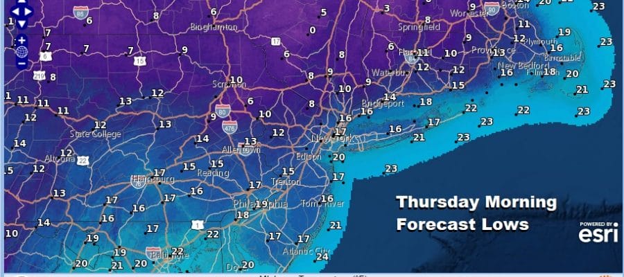
Tonight’s lows will settle into the 20s as skies clear out everywhere after midnight. Wednesday is going to bring the next cold front along from the northwest. A strong upper trough will be swinging into New England and it is the kind of set up that could trigger a few snow showers and there is also the chance of a heavier line of snow squalls moving through later in the afternoon. It would be like a summertime line of showers though they would be snow showers this time and it might snow hard briefly and whiten up the ground in some spots. Some of you may miss them altogether.
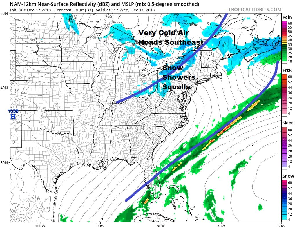
Once the front passes very cold air on gusty northwest winds will move in. Thursday morning lows will be down in the teens and single digits and wind chills will make it feel like it is a good 10 degrees colder.
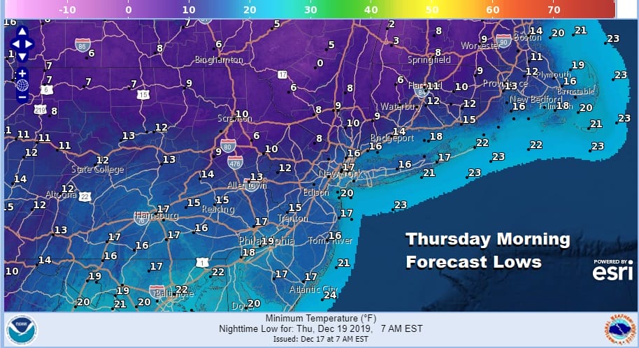
Thursday will be the coldest day of the young almost winter season so far with daytime highs not out of the 20s. Thursday night will be clear and cold with teens to near 20 for lows. Friday looks nice with some sunshine with highs getting back into the 30s.

The weekend will see a storm develop in the Gulf of Mexico and move east over Florida and then off the Southeast Coast of the US. This actually looks like a rather interesting looking gale center that is so far south. However the upper flow is unfavorable for a storm to move up the East Coast.
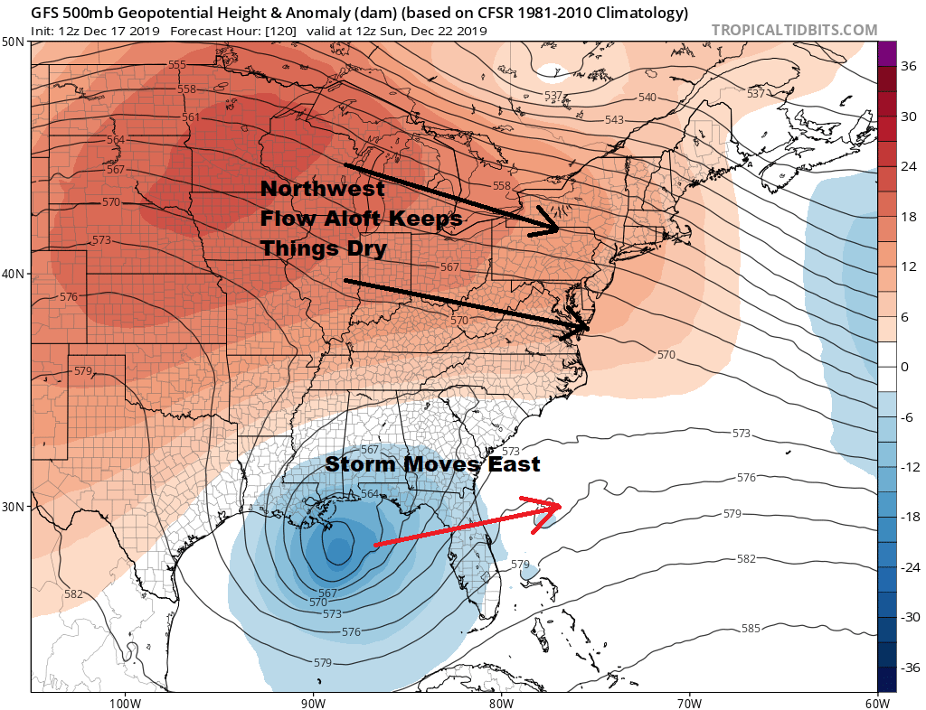
The flow is split with a northwest flow over us down to Virginia and nothing there to phase it with the wrapped up southern energy in the Gulf of Mexico. That would be forced eastward and out to sea well to the south of here. We would see some sunshine for both Saturday and Sunday. The cold air mass for Thursday into Friday will be moving out and temps should bounce well into the 30s on Saturday and the nice 40s on Sunday.
BE SURE TO DOWNLOAD THE FREE METEOROLOGIST JOE CIOFFI WEATHER APP &
ANGRY BEN’S FREE WEATHER APP “THE ANGRY WEATHERMAN!
MANY THANKS TO TROPICAL TIDBITS FOR THE USE OF MAPS
Please note that with regards to any severe weather, tropical storms, or hurricanes, should a storm be threatening, please consult your local National Weather Service office or your local government officials about what action you should be taking to protect life and property.


