Dry Through Tuesday Wind & Rain Developing Wednesday
As Coastal Storm Forms Off Delaware Coast
The new work week begins on a bright note. We still have a storm system east of Atlantic Canada and a flow of seasonable air across the Northeast and Mid Atlantic states. This makes for a stable atmosphere over Eastern Pennsylvania to southern New England. Skies should be partly to mostly sunny today across Eastern Pennsylvanita to Southern New England. Temperatures this afternoon will top out mostly in the low to mid 70s. Northwest winds will be gusting at times 20 to 25 mph especially near the coast so while it will be a bit breezy, winds will not get out of hand.
SATELLITE WITH LIGHTNING STRIKES
WEATHER RADAR
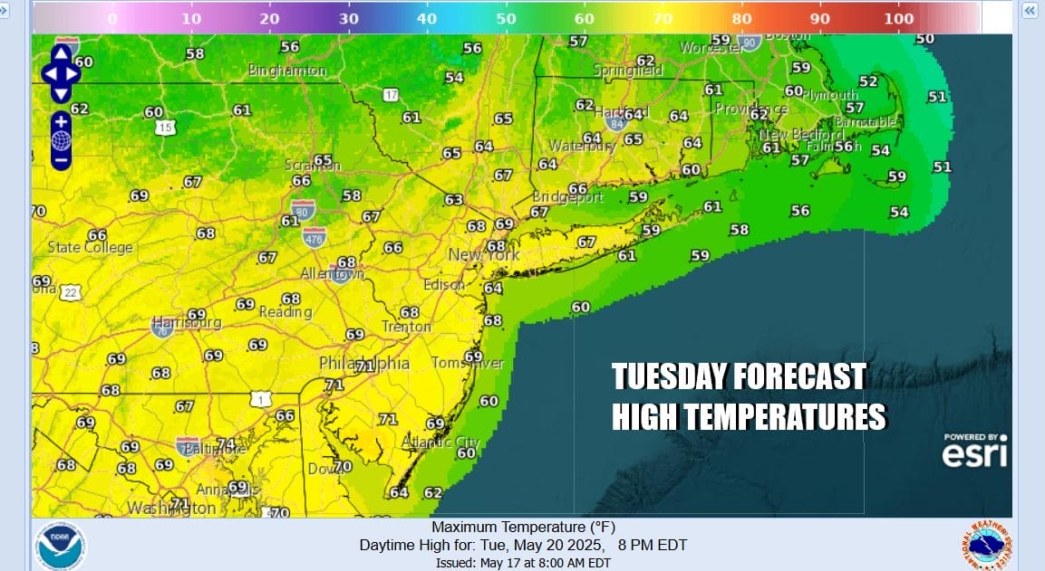
Radars should remain nice and quiet today with no showers in the forecast. Skies will be mainly clear tonight with most lows in the 40s inland and lower 50s along the coast and warmer urban locations. Tuesday looks to a day of mainly sunny skies though it will be cooler than today. Most highs will be in the upper 60s to some lower 70s as winds turn more to the northeast and east.
Strong low pressure and a trailing cold front is going to be producing severe weather from the Southern Plains to the Middle Mississippi Valley today and it will shift eastward into the Ohio & Tennessee Valleys and the Deep South Tuesday. This low will track east and then eventually redevelop off the coast of Delaware and New Jersey Wednesday into Wednesday night.
This low is a little further east and south on recent model runs which lessens the potential for a full blown May noreaster but gloom & doom rainy conditions will develop during the day Wednesday, first in Pennsylvania and the spreading into New Jersey and New York state later in the day and into the evening. Temperatures are going to be cool and raw thanks to easterly winds. Wednesday highs will be mostly in the 50s.
Rain will continue Wednesday night into early Thursday and then become more showery in nature. Winds will shift more to the north northeast but we will still have lots of clouds. It will remain damp and raw with high temperatures again just in the 50s. Rainfall amounts will be an inch and a half to 2 inches across much of Pennsylvania as well as over Long Island and Southeastern New England while areas in between like the Hudson Valley and New Jersey will see an inch to an inch and a half of rain.
Friday is getaway day for the Memorial Day holiday weekend. Since we have a slow moving system offshore and a rather deep upper trough over the Northeast and Northern Mid Atlantic states Friday and Saturday, improving weather conditions will be slow to occur. We will still have lots of clouds around Friday with the risk for some passing showers. Highs will be in the upper 50s and lower 60s.
Saturday should see some improvement and maybe some sunshine will come into the mix but clouds will develop and a passing shower or two can’t be ruled out. However it will be the sort of day where much of the time it will be dry and not everyone will see showers. Highs will be back in the 60s. Sunday it gets a bit better with more sun, few clouds and maybe an isolated shower with highs in the 60s. Monday likely will be the best of the 3 days with some sunshine and highs reaching the upper 60s and lower 70s. Of the 3 holiday weekends that are considered part of the summer vacation season, Memorial Day weekend is the one where you are most like to see rain on at least 1 of the 3 days and this year it seems to be playing close to form.
BE SURE TO DOWNLOAD THE FREE METEOROLOGIST JOE CIOFFI WEATHER APP &
ANGRY BEN’S FREE WEATHER APP “THE ANGRY WEATHERMAN!
MANY THANKS TO TROPICAL TIDBITS FOR THE USE OF MAPS
Please note that with regards to any severe weather, tropical storms, or hurricanes, should a storm be threatening, please consult your local National Weather Service office or your local government officials about what action you should be taking to protect life and property.