Dry Through Thanksgiving Day Rain Arrives Friday Ahead of the Weekend
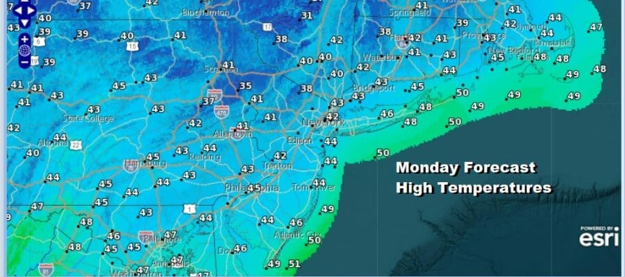
Thanksgiving week begins and the good news is that the weather across much of the US this week through Wednesday and probably into Thanksgiving day will be relatively uneventful. There are no major storms through this week, though we will have some storminess to deal with later Friday into Saturday. More on that in a bit. In the meantime the historic lake effect snows are just about done now as the upper trough in the Northeast begins to slowly pull away and lift out to the northeast. We hit the bottom in temperatures this morning with lows in the 20s everywhere and even a few teens in cold spots. However with sunshine today and a bit less wind, highs should make it back into the 40s this afternoon.
SATELLITE

WEATHER RADAR

Satellite and radar loops are nice and quiet in Eastern Pennsylvania to Southern New England. The last of the lake effect is drying out in North Central NY and that historic snowstorm is done. Going forward we here in Eastern Pennsylvania to Southern New England, we will be calm and quiet with clear skies tonight. Most lows tonight will be in the 20s inland and lower 30s coast and warmer urban areas.
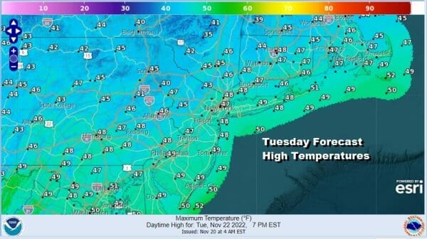
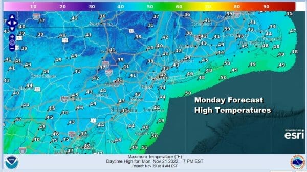
There is a weak weather front dropping southward from Eastern Canada but the front doesn’t have much with it at all and the air behind it is a little colder but that only slows the moderation rate of temperatures as we go through the week. Tuesday we will see some sunshine with highs in the mid to upper 40s. Wednesday we will take it up another notch with highs reaching the low and middle 50s with some sunshine.
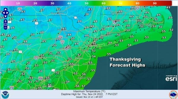
Thanksgiving Day looks fine with some sunshine and a few clouds. We should see highs perhaps a little lower than Wednesday as a weak high builds into Southeastern Canada and some of that cooler air will bleed southward but not much to make any kind of a difference. Highs will be in the upper 40s and lower 50s.
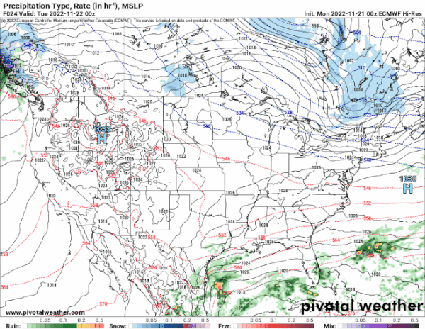
Now comes the issue for the week. Low pressure will be moving across the South while energy drives southeast from the Great Lakes. This will likely bring low pressure up the Appalachians on Friday. Since there is no cold air around we are looking at rain later Friday into Saturday and the rain could be substantial, on the order of an inch or more of rain. Friday highs will be in the 40s inland and lower 50s coast and South Jersey. Models are in a state of disagreement with the GFS model much slower with rain and keeping it out until later Saturday or Sunday but for now we will go with the faster European which means that weather conditions should improve later Saturday into Sunday.
BE SURE TO DOWNLOAD THE FREE METEOROLOGIST JOE CIOFFI WEATHER APP &
ANGRY BEN’S FREE WEATHER APP “THE ANGRY WEATHERMAN!
MANY THANKS TO TROPICAL TIDBITS & F5 WEATHER FOR THE USE OF MAPS
Please note that with regards to any severe weather, tropical storms, or hurricanes, should a storm be threatening, please consult your local National Weather Service office or your local government officials about what action you should be taking to protect life and property.


