Dry Into Friday Morning A Little Rain Possible Friday Evening
Then Nice For The Weekend
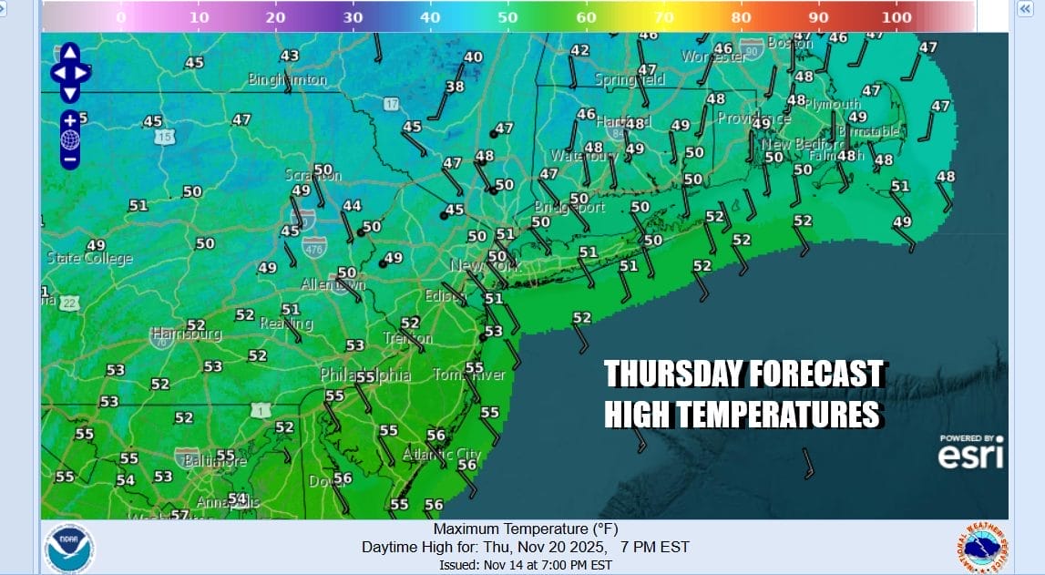
A chilly start to Thursday leads to temperatures rising into the upper 40s and lower 50s later today. We are between weather systems but we also have the beginnings of an onshore flow. It isn’t a particularly strong onshore flow. Patchy clouds are streaming eastward, blow off from thunderstorms and heavy rain in the Southern Plains to the Middle Mississippi Valley. We should be no worse than partly sunny sky wise. Radars locally in the Eastern US are nice and quiet and should remain so into early Friday. Tonight look for some clouds around with lows generally in the 30s to around 40. Some 20s are possible inland.
SATELLITE WITH LIGHTNING STRIKES
WEATHER RADAR
Low pressure in the Southern Plains today is producing a large area of heavy rain and flash flooding potential from Central and Northeast Texas northeastward to Missouri. This rain will spread eastward over the lower Ohio and Tennessee Valley overnight and Friday but it is another weather system where there is no real room for it to develop into something more important.
As the system gets suppressed to the south, some of the rain from this will nudge northward Friday which will be a day of increasing clouds. There could be a little bit of light rain that pops up later in the afternoon but the main push of rain will be Friday night into early Saturday morning. Temperatures Friday will be topping out in the 50s ahead of this. Rain fall should not amount to much, generally less than a quarter inch though it might be a bit more in Southern New Jersey and points south.
While there might be some rain lingering around Saturday morning it should be mostly done shortly after sunrise. Then we spend the rest of the day improving with leftover clouds giving way to some sunshine and highs generally in the 50s. A cooler air mass builds into Southeastern Canada and New England beginning Sunday and that will bleed some colder air southward. Sunday and Monday should be no worse than partly sunny with highs both days in the upper 40s & lower 50s.
BE SURE TO DOWNLOAD THE FREE METEOROLOGIST JOE CIOFFI WEATHER APP \&
ANGRY BEN’S FREE WEATHER APP “THE ANGRY WEATHERMAN!
MANY THANKS TO TROPICAL TIDBITS FOR THE USE OF MAPS
Please note that with regards to any severe weather, tropical storms, or hurricanes, should a storm be threatening, please consult your local National Weather Service office or your local government officials about what action you should be taking to protect life and property.