Dry Cold Weekend Next Cold Front Monday Rain Snow Showers Likely

Weather in 5/Joe & Joe Weather Show Latest Podcast
Dry Cold Weekend Next Cold Front Monday Rain Snow Showers Likely
5 storms in 21 days was a lot to handle and all of them kept us very busy in the weather world. Finally that pattern has broken down. The blocking is gone. The cold air source from Canada has relaxed. Now we have a couple of nice albeit cold days to deal with this weekend.
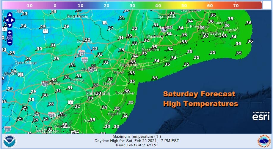
We are looking at some sunshine on this Saturday but it will be brisk and cold with highs just in the upper 20s to lower 30s in most places. Some spots should be able to break through the freezing mark by a degree or two. Then we have a clear night ahead of us with lows in the teens to lower 20s. Sunday will be sunny and cold with most highs in the low to mid 30s. It is simple and straight forward.
SATELLITE

We should see some clouds in the mix today especially inland. Some snow showers will show up in lake effect land in upstate NY and also we have an upper trough moving through the Northeast US. There might be the outside chance for an isolated snow shower this afternoon as the trough goes by otherwise there are no issues on the radar through Sunday.
F5 WEATHER RADARS


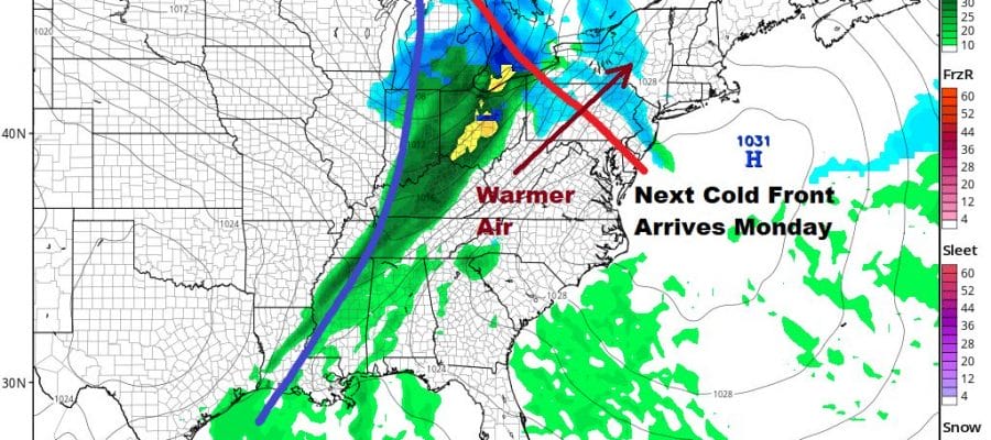
High pressure will be offshore to our east Sunday night setting up a southwest flow of air. An approaching cold front will head here on Monday. Ahead of that Sunday night is a bit of a warm front and with that there could be a few snow showers as it moves south to north. We are mentioning just a chance here and it won’t amount to much as it goes by.

Monday the cold front nears and with that there will be some rain and snow showers. Inland areas might see a burst of snow if the precipitation arrives fast enough in the morning or early afternoon Monday. Highs Monday will be in the mid 30s to lower 40s. Drier air follows for Tuesday into Wednesday. Another weak front passes late Wednesday. We will watch that to see if it stalls to our south and if a wave develops on that front to impact the weather for later Thursday into Friday. More on that later in the weekend. For now I’m taking a well deserved and long needed break for a day or so.
BE SURE TO DOWNLOAD THE FREE METEOROLOGIST JOE CIOFFI WEATHER APP &
ANGRY BEN’S FREE WEATHER APP “THE ANGRY WEATHERMAN!

MANY THANKS TO TROPICAL TIDBITS & F5 WEATHER FOR THE USE OF MAPS
Please note that with regards to any severe weather, tropical storms, or hurricanes, should a storm be threatening, please consult your local National Weather Service office or your local government officials about what action you should be taking to protect life and property.


