
Drought Relief Coming Next Week
Drought Relief Coming Next Week
The weather pattern change process continues. It looks that one of the biggest worries in the pattern change turns out to be happening first. We seem to be going to a more active pattern with weather systems coming across every couple of days. So far we have seen some early snows in parts of the area and parts of the Northeast specifically upstate NY had a very fierce lake effect snow event with some records set. Now it appears we may get 2 shots for much needed drought relief coming next week.
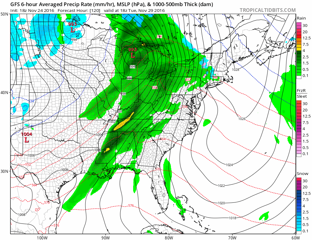
The first of 2 weather systems arrives late Tuesday with rain into Wednesday. The front with this system is going to stall out to our south and west because the first primary low takes a track pretty far to the left. It is going to take a second stronger wave to swing everything eastward. Model trends have been deeper and a little further east with each successive run. This puts us in line for a very decent shot of rain in terms of volume between the two systems.
DROUGHT RELIEF GFS RAINFALL FORECAST
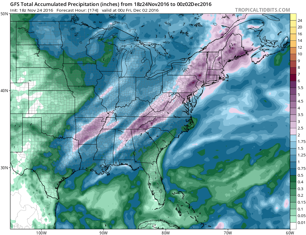
The latest GFS model run brings 4 inches or more of rain over a large area of the Northeast and Middle Atlantic States. Even the Carolinas where fires have been burning get some drought relief. As each system goes by it swings the trough position a little further to the east and puts us closer to a wintry pattern. 
Models diverge somewhat in the long range. The GFS model suggests that there will be one more trough in the west later in the period which delays the arrival of any cold until late in the forecast period (day 12-16). The European however is much different and suggests cold air arrives in day 8-10.

The European model is very bullish on an early wintry pattern day 8-10 with the establishment of a low at 50N 50W or what is known as the 50-50 low. A trough begins to set up to the west. An upper air pattern such as this would establish much below normal temperatures in the east as we move into early December and opens the door for snow opportunities. The large differences in the two models seem to hinge on the idea that the GFS phases the trough in the west while the GFS keeps the southwest upper air storm further south and the trough leaves it there and instead digs into the Midwest. Models have been guilty of phasing too much in the last several weeks. The GFS did trend more toward the European solution in the last 2 runs through day 7 but remains steadfast in its idea beyond day 7. This grueling process continues. We can say that the North Atlantic Oscillation stays strongly negative through the next 2 weeks along with the East Pacific Oscillation. That combination may be enough to signal a colder pattern developing as we move into the first 2 weeks of December.
MANY THANKS TO TROPICAL TIDBITS FOR THE WONDERFUL USE OF THE MAPS
SNOW REMOVAL COMPANIES FOR YOUR WINTER NEEDS
LONG ISLAND ROCKLAND COUNTY Connecticut

![]()


WINTER 2016-2017 PART 1 OCEAN WATER TEMPERATURES
WINTER 2016-2017 PART 2 ARCTIC SEA ICE AND SIBERIAN SNOW COVER
FiOS1 News Weather Forecast For Long Island
FiOS1 News Weather Forecast For New Jersey
FiOS1 News Weather Forecast For Hudson Valley
NATIONAL WEATHER SERVICE SNOW FORECASTS
LATEST JOESTRADAMUS ON THE LONG RANGE
Weather App

Don’t be without Meteorologist Joe Cioffi’s weather app. It is really a meteorologist app because you get my forecasts and my analysis and not some automated computer generated forecast based on the GFS model. This is why your app forecast changes every 6 hours. It is model driven with no human input at all. It gives you an icon, a temperature and no insight whatsoever.
It is a complete weather app to suit your forecast needs. All the weather information you need is right on your phone. Android or I-phone, use it to keep track of all the latest weather information and forecasts. This weather app is also free of advertising so you don’t have to worry about security issues with your device. An accurate forecast and no worries that your device is being compromised.
Use it in conjunction with my website and my facebook and twitter and you have complete weather coverage of all the latest weather and the long range outlook. The website has been redone and upgraded. Its easy to use and everything is archived so you can see how well Joe does or doesn’t do when it comes to forecasts and outlooks.
Just click on the google play button or the apple store button on the sidebar for my app which is on My Weather Concierge. Download the app for free. Subscribe to my forecasts on an ad free environment for just 99 cents a month.
Get my forecasts in the palm of your hand for less than the cost of a cup of Joe!
![]()
