Dreary Rainy Gloom And Doom Weekend And First Part of New Week

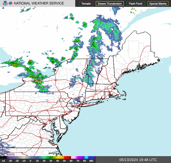
What is left of Hurricane Ian is a large non tropical feature in the atmosphere. The remant low is in Southwestern Virigina and from this an arc of rain has moved northward up the coast and that is what most of Eastern Pennsylvania and Southern New England is seeing. However once that air of rain plays through, we transition over to a cloudy and raw day. Already areas in Southern New Jersey and Southern Pennsylvania are mostly out of the rain and the southern edge of the rain shield is moving steadily northward. The HRRR loop above shows much of the rain shifts to the east into Southeastern New England during this afternoon.
SATELLITE

WEATHER RADAR
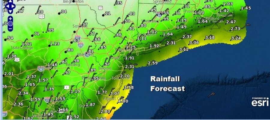
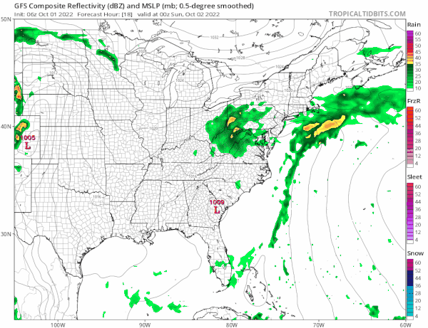
As far as rainfall amounts are concerned, fortunately we are not dealing with any sort of well defined core from Ian. In fact take a look on the radar down in Virginia and North Carolina and there is literallyh no precipitation being produced. Rainfall amounts will be generous and beneficial but no widespread flash flooding is indicated and rainfall amounts will be on the order of an inch or 2 with areas north and west of NYC, Philadelphia line getting under an inch. This is total rainfall through Monday.

As far as temperatures are concerned, we don’t see much room for upside today given the clouds and the northeast wind. South Jersey and points southward will top in the mid to upper 60s until the northeast wind firmly takes hold which it already has in most areas. Otherwise for everyone else, highs will be in the 50s.

It is going to be tough trying to figure out what happens tonight into Tuesday. We will be sitting with a strong upper low nearby with low pressure to the south just offshore and a strong high to the north. This is going to keep us in an onshore flow at least into Tuesday so most of the time it will be overcast and a bit on the raw side. The northeast wind will pick up from time to time especially from Long Island and New Jersey southward.
As far as the day to day outlook is concerned the best approach is to view this as a stretch of cloudy raw weather through at least Tuesday. There will be limited if any sun at all. From time to time it will rain but there will be dry stretches as well. Sometimes there could be just some light rain or drizzle especially along the coast. Speaking of the coast the northeast fetch will likely result in some minor coastal flooding at high tide. We are moving to the lower point in the tide cycle so that is a plus.

As for temperatures, they aren’t going anywhere. Most places will see daytime highs in the 50s to at best near 60s Sunday and again on Monday. We might nudge it up a bit Tuesday with highs in the upper 50s and lower 60s and perhaps 60 to 65 will do it on Wednesday. We expect to being to see some slow improvement from west to east Wednesday as low pressure offshore begins to pull away to the east. Late this week a cold front will bring in a very cool Canadian air mass just in time for next weekend.
BE SURE TO DOWNLOAD THE FREE METEOROLOGIST JOE CIOFFI WEATHER APP &
ANGRY BEN’S FREE WEATHER APP “THE ANGRY WEATHERMAN!
MANY THANKS TO TROPICAL TIDBITS & F5 WEATHER FOR THE USE OF MAPS
Please note that with regards to any severe weather, tropical storms, or hurricanes, should a storm be threatening, please consult your local National Weather Service office or your local government officials about what action you should be taking to protect life and property.


