
Downpours Thunderstorms Moving Through Today
Downpours Thunderstorms Moving Through Today
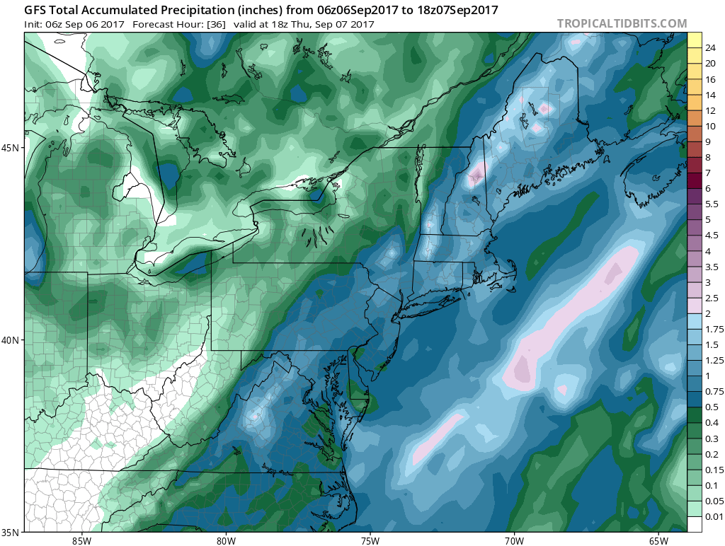
Looking at the satellite loop this morning we can see the north south line of clouds as we have a cold front stalled along the coast. Ripples along that front are producing showers and some thunderstorms with some locally heavy downpours. This will continue on and off throughout the day. Notice that the clouds are moving south to north along the East Coast which is a signature of what happens when fronts stall out. Once the last wave passes overnight weather conditions will finally being to improve. Temperatures today will settle in the upper 60s and lower 70s and without any sunshine that is pretty much where they will sit all day.
SATELLITE LOOP

REGIONAL RADAR

Radars are fairly loaded up this morning and we have even seen a few severe thunderstorms move through a few areas. Some places today could wind up seeing a decent amount of rain fall in the order of an inch or so espeically if you get under one of those big storms.
LOCAL RADAR NEW YORK CITY

LOCAL RADAR PHILADELPHIA


We should see improving weather conditions on Thursday with increasing amounts of sunshine and temperatures in the 70s. Friday through Sunday look like 3 great days with sunshine and highs on average in the low to mid 70s each day with night time lows in the 50s.
HURRICANE IRMA OVER ST MARTIN MOVING TO ANGUILLA
Hurricane Irma is absolutely raking the Northern Leeward Islands as the eye of this category 5 hurricane is passing right over the island of Saint MartIn. The Northern Eyewall is over Anguilla as well. Winds remains at 185 MPH.

..EYE OF POTENTIALLY CATASTROPHIC CATEGORY 5 HURRICANE IRMA
PASSES OVER ST. MARTIN…
…NORTHERN EYEWALL POUNDING ANGUILLA…
SUMMARY OF 800 AM AST…1200 UTC…INFORMATION
———————————————-
LOCATION…18.1N 63.3W
ABOUT 15 MI…25 KM W OF ST. MARTIN
ABOUT 15 MI…25 KM WSW OF ANGUILLA
MAXIMUM SUSTAINED WINDS…185 MPH…295 KM/H
PRESENT MOVEMENT…WNW OR 285 DEGREES AT 16 MPH…26 KM/H
MINIMUM CENTRAL PRESSURE…918 MB…27.11 INCHES
WATCHES AND WARNINGS
——————–
CHANGES WITH THIS ADVISORY:
None
SUMMARY OF WATCHES AND WARNINGS IN EFFECT:
A Hurricane Warning is in effect for…
* Antigua, Barbuda, Anguilla, Montserrat, St. Kitts, and Nevis
* Saba, St. Eustatius, and Sint Maarten
* Saint Martin and Saint Barthelemy
* British Virgin Islands
* U.S. Virgin Islands
* Puerto Rico, Vieques, and Culebra
* Dominican Republic from Cabo Engano to the northern border with
Haiti
* Guadeloupe
* Southeastern Bahamas and the Turks and Caicos Islands
A Hurricane Watch is in effect for…
* Haiti from the northern border with the Dominican Republic to Le
Mole St. Nicholas
* Turks and Caicos Islands
* Southeastern Bahamas
* Cuba from Matanzas province eastward to Guantanamo province
* Central Bahamas
A Tropical Storm Warning is in effect for…
* Dominican Republic from south of Cabo Engano westward to the
southern border with Haiti
A Tropical Storm Watch is in effect for…
* Haiti from south of Le Mole St. Nicholas to Port-Au-Prince
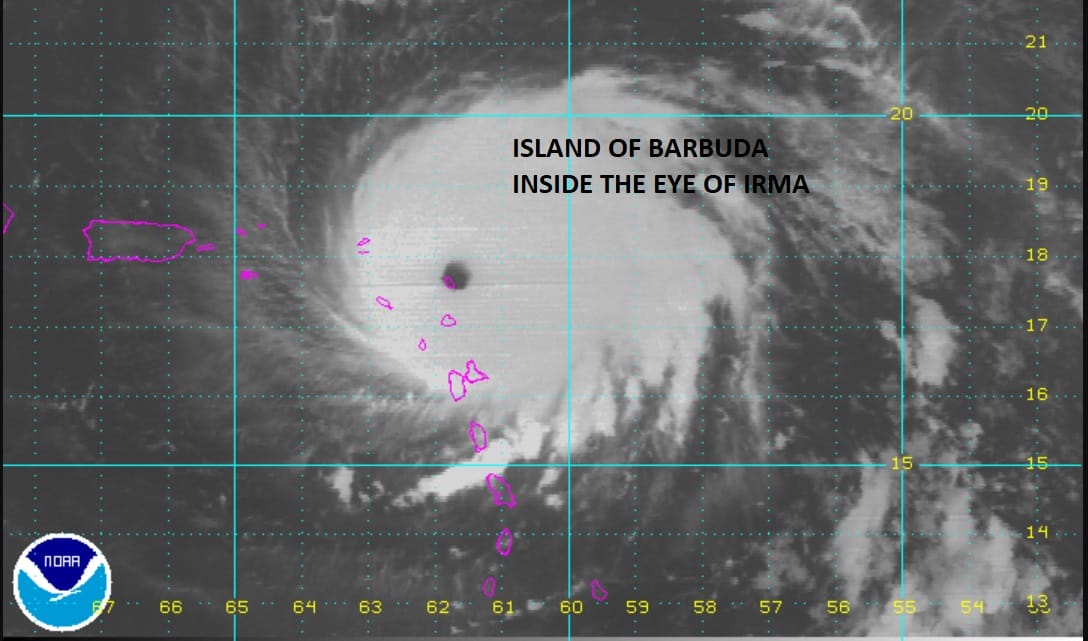
This satellite picture was at 2am this morning when the almost perfectly circular eye of this category 5 hurricane was sitting right over the island of Barbuda.
 GET JOE A CIGAR IF YOU LIKE

FiOS1 News Weather Forecast For Long Island
FiOS1 News Weather Forecast For New Jersey
FiOS1 News Weather Forecast For Hudson Valley


