
Dorian Nears the Windwards, Low Offshore Organizing Well East of Carolinas
I would like it understood right from the beginning here that Dorian is a very small cyclone. Gales only extend out about 40 miles or so from the center with the strongest winds in a very small area near the center. Therefore the impact here to the Windwards will be confined in a very tight circle; going over one island perhaps with not much happening to the islands on either side. That said if you are in the target of the very narrow path of winds it will get rocky as the storm passes through. The satellite loop shows the impact of dry air to the north that gets entrained in the circulation of the storm. Bursts of strengthening have occurred but the process has been rather slow. Conditions in general remain favorable for strengthening. The storm does have a well defined small core so we could see some quick changes strengthewise in both directions in the coming days.
DORIAN SATELLITE LOOP

Tropical Storm Dorian Advisory Number 10
NWS National Hurricane Center Miami FL AL052019
500 PM AST Mon Aug 26 2019
…TROPICAL STORM WATCH ISSUED FOR PUERTO RICO…
…TROPICAL STORM CONDITIONS EXPECTED IN THE WINDWARD ISLANDS LATER
TONIGHT WITH HURRICANE CONDITIONS POSSIBLE ON TUESDAY…
SUMMARY OF 500 PM AST…2100 UTC…INFORMATION
———————————————-
LOCATION…12.7N 58.8W
ABOUT 60 MI…95 KM SE OF BARBADOS
ABOUT 165 MI…270 KM ESE OF ST. LUCIA
MAXIMUM SUSTAINED WINDS…60 MPH…95 KM/H
PRESENT MOVEMENT…WNW OR 290 DEGREES AT 14 MPH…22 KM/H
MINIMUM CENTRAL PRESSURE…1002 MB…29.59 INCHES
WATCHES AND WARNINGS
——————–
CHANGES WITH THIS ADVISORY:
A Tropical Storm Watch has been issued for Puerto Rico.
SUMMARY OF WATCHES AND WARNINGS IN EFFECT:
A Hurricane Watch is in effect for…
* St. Lucia
A Tropical Storm Warning is in effect for…
* Barbados
* Martinique
* St. Lucia
* St. Vincent and the Grenadines
A Tropical Storm Watch is in effect for…
* Dominica
* Grenada and its dependencies
* Saba and St. Eustatius
* Puerto Rico
A Hurricane Watch means that hurricane conditions are possible
within the watch area, in this case, within the next 24 hours.
A Tropical Storm Warning means that tropical storm conditions are
expected somewhere within the warning area within 36 hours.
A Tropical Storm Watch means that tropical storm conditions are
possible within the watch area, generally within 48 hours.
Interests in the Virgin Islands and Hispaniola should monitor the
progress of Dorian as watches for these areas could be required
tonight or Tuesday.
For storm information specific to your area in the United
States, including possible inland watches and warnings, please
monitor products issued by your local National Weather Service
forecast office. For storm information specific to your area
outside the United States, please monitor products issued by your
national meteorological service.
DISCUSSION AND OUTLOOK
———————-
At 500 PM AST (2100 UTC), the center of Tropical Storm Dorian was
located by satellite and Martinique radar near latitude 12.7 North,
longitude 58.8 West. Dorian is moving toward the west-northwest near
14 mph (22 km/h) and this motion is expected to continue through
Tuesday night, followed by a turn toward the northwest on Wednesday.
On the forecast track, the center of Dorian is expected to move near
the Windward Islands this evening and tonight and move into the
eastern Caribbean Sea on Tuesday. Dorian is forecast to pass near or
south of Puerto Rico on Wednesday and approach eastern Hispaniola
Wednesday night.
Maximum sustained winds are near 60 mph (95 km/h) with higher gusts.
Some strengthening is forecast during the next few days, and Dorian
could be near hurricane strength when it passes through the northern
Windward Islands on Tuesday, and it is expected to be a hurricane
when it moves near Puerto Rico and eastern Hispaniola.
Satellite-derived surface wind data indicate that Dorian remains a
compact tropical cyclone. Tropical-storm-force winds extend outward
up to 45 miles (75 km) from the center.
The estimated minimum central pressure is 1002 mb (29.59 inches).
The dilemmas in the forecast are several. Front and center is track of course and given the weakness in the upper high to the north Dorian should turn more northwestward in the Eastern Caribbean which increases the threat to Puerto Rico and the Virgin Islands. However given the small size of the storm and the dry environment it lives in, the target zone is rather small. What exactly are we going to be dealing with from a standpoint of intensity?
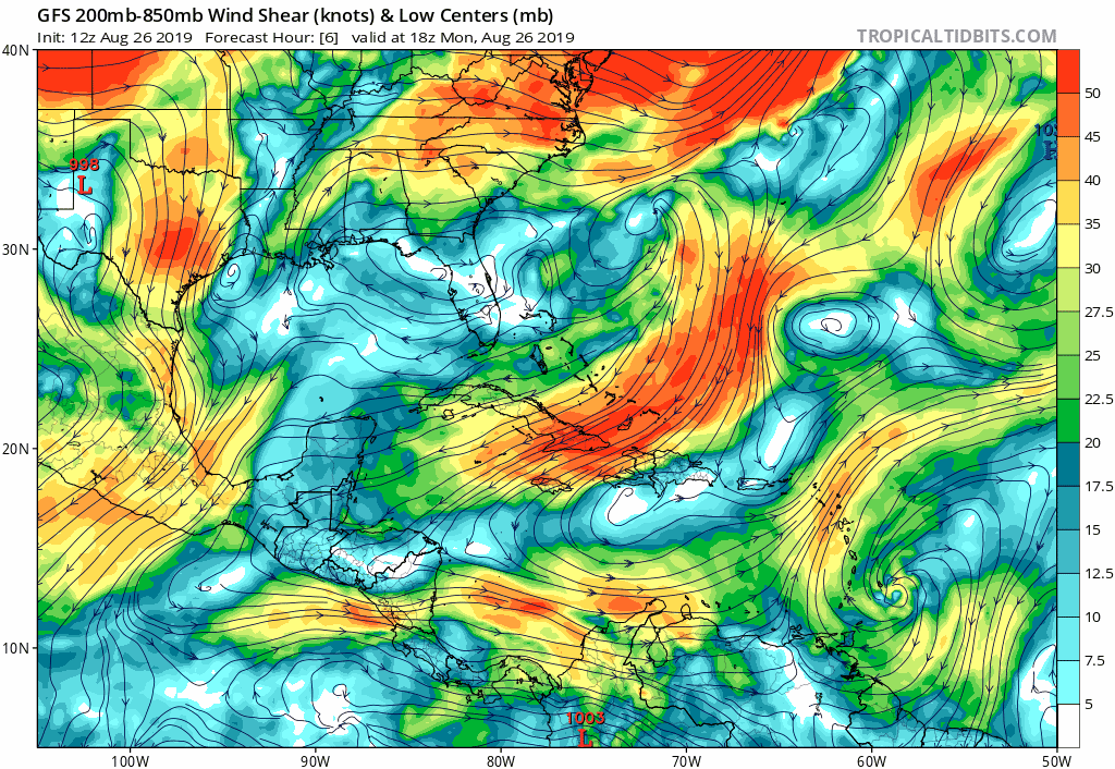
The areas of yellow and orange represents strong winds in the atmosphere above 5000 feet. Tropical systems do not like strong winds like this as they rip the storms apart blowing thunderstorms away from the center. The GFS has been forecasting hostile conditions developing in the Eastern Caribbean after Tuesday so in theory at least Dorian could be sheared apart to a remnant low before it even reaches Puerto Rico or the islands surrounding it.
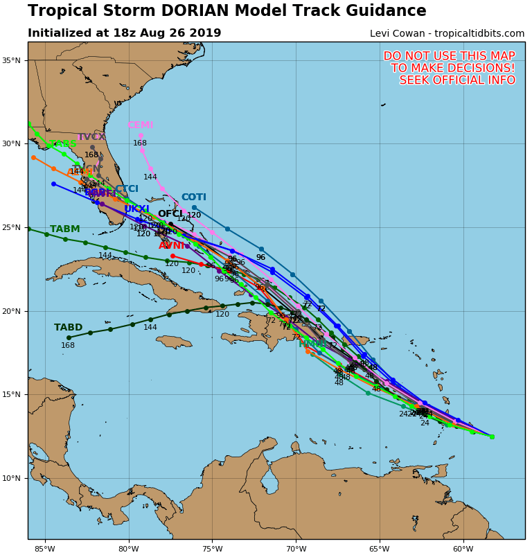
The European model has been showing the same idea up until last night and now suggests the wind shear won’t be an issue here. If that is the case Dorian could make it north of Puerto Rico and the Dominican Republic and into the Bahamas later this week. Conditions north of these islands will be quite favorable for strengthening IF it makes it there in one piece. A buliding upper high to the north and northeast of a storm in the Bahamas would drive it westward toward Florida but we then come back to the original question which is will Dorian survive the Eastern Caribbean?
TROPICAL DEPRESSION FORMS SOUTHEAST OF THE CAROLINAS
Satellite loops this afternoon show the low off the Southeast coast is organizing. You can see a low level circulation center on the edge of convection that is east of the center. There isn’t much thunderstorm activity going on north and west of the low center right now but with conditions favorable for some strengthening we could see this becoming a tropical storm tonight or Tuesday.
SATELLITE

..NEW TROPICAL DEPRESSION FORMS MIDWAY BETWEEN BERMUDA AND THE
UNITED STATES…
SUMMARY OF 500 PM EDT…2100 UTC…INFORMATION
———————————————-
LOCATION…31.7N 72.5W
ABOUT 295 MI…480 KM SE OF CAPE HATTERAS NORTH CAROLINA
MAXIMUM SUSTAINED WINDS…35 MPH…55 KM/H
PRESENT MOVEMENT…E OR 80 DEGREES AT 2 MPH…4 KM/H
MINIMUM CENTRAL PRESSURE…1010 MB…29.83 INCHES
WATCHES AND WARNINGS
——————–
There are no coastal watches or warnings in effect.
DISCUSSION AND OUTLOOK
———————-
At 500 PM EDT (2100 UTC), the center of Tropical Depression Six was
located near latitude 31.7 North, longitude 72.5 West. The
depression is moving toward the east near 2 mph (4 km/h). A slow
eastward or northeastward motion is forecast during the next day or
so. The cyclone is expected to begin to accelerate northeastward
on Wednesday, and this general motion should continue through
Thursday. On the forecast track, the center of the depression will
remain well east of the east coast of the United States.
Maximum sustained winds are near 35 mph (55 km/h) with higher gusts.
Some gradual strengthening is possible during the next day or two,
and the depression is forecast to become a tropical storm tonight
or Tuesday.
The estimated minimum central pressure is 1010 mb (29.83 inches).
There are no changes in the outlook here. It is so far out to the east already. It will probably drift northward through Tuesday and then the Wednesday cold front should punt this out to the northeast later Wednesday.

If this eventually develops into a tropical storm it should pass east of Cape Cod and it could head toward Nova Scotia late this week.
MANY THANKS TO TROPICAL TIDBITS FOR THE USE OF MAPS
Please note that with regards to any tropical storms or hurricanes, should a storm be threatening, please consult your local National Weather Service office or your local government officials about what action you should be taking to protect life and property.