Dorian Becomes a Hurricane 75 MPH Winds Risk Grows for Florida SE US
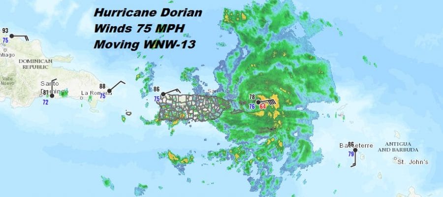
Satellite, radar, and surface observations this afternoon show that Dorian is now a hurricane with top winds of 75 mph. Saint Thomas in the Virgin Islands has been reported frequent winds of 75 mph for the last several hours. Dorian’s core has improved and the storm has tightened up. The mid level dry air has disappeared and the track is far enough east where the storm is not being impacted by the mountainous terrain of Puerto Rico.
SATELLITE

DORIAN & ERIN

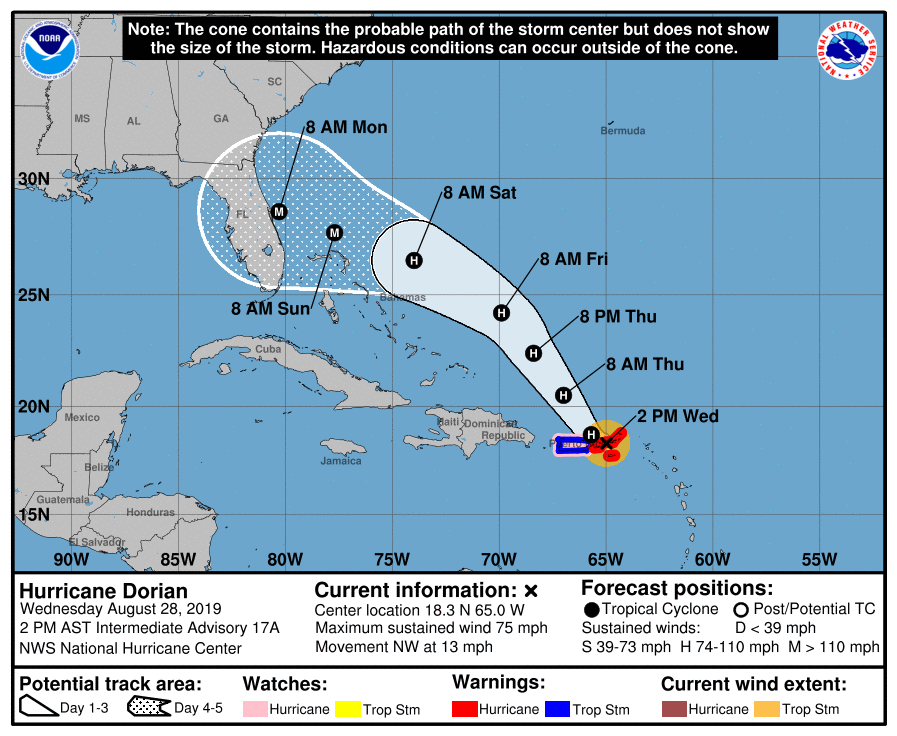
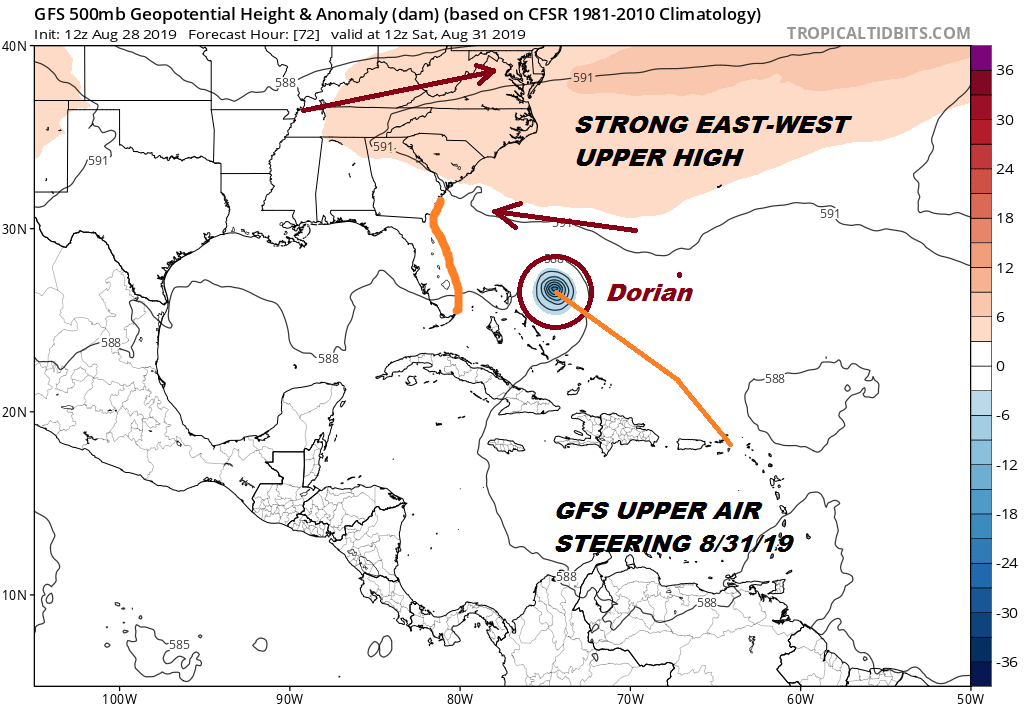
Dorian will continue to the northwest and emerge into the Atlantic. As Tropical Depression Erin to the northwest pulls away a strong upper high will build across the Atlantic into the Southeast US. This will be the steering mechanism and the “brick wall” that Dorian will move along on a west northwest course. The risks grow for Florida this weekend. Weather models all show this ridge building with the European model the strongest of the bunch and with the furthest south track into Southern Florida while the GFS is a bit further north into the Central Florida coast. It is all about the upper high as far as track. We here are protected with the westerly flow of the jet stream south into Virginia so this is not a threat for the Middle Atlantic or the Northeast US.
Meanwhile we have been seeing showers and downpours moving over Long Island and Southern New England while to the west some showers and downpours from the cold front are moving eastward and heading into Eastern Pennsylvania and New Jersey. Look for these downpours for the evening commute as the cold front moves through. Weather conditions will improve later tonight as skies clear.
LOCAL RADAR NEW YORK CITY

LOCAL RADAR PHILADELPHIA 

There are no changes in the outlook going forward Thursday through Saturday. All three days will feature a good deal of sunshine. HIghs will be in the low to mid 80s Thursday and Friday with reasonable humidity. Another cold front passes Friday night with a few clouds but I’m leaving any showers out of the forecast. Saturday will be the best day of the holiday weekend with lots of sunshine, bone dry humidity and highs mostly in the 70s.
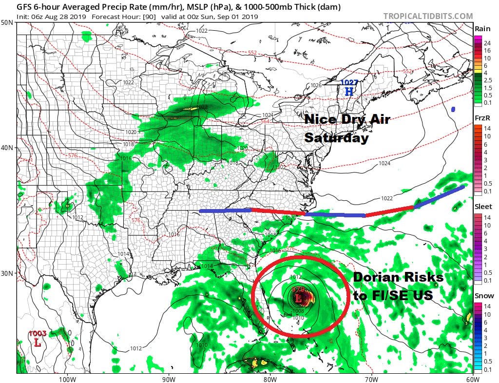
Sunday morning Dorian will be probably making landfall somewhere in Florida or the Southeast US though the risks are rising higher for a Florida east coast landfall and possibly as a major hurricane. High pressure will still be protecting us but it will moving out to the east and setting up an onshore flow for Sunday and Monday. This brings clouds into the mix along with the chance of the odd shower though most of the time it won’t be raining. Highs Sunday and Monday will be in the 70s.
MANY THANKS TO TROPICAL TIDBITS FOR THE USE OF MAPS
Please note that with regards to any tropical storms or hurricanes, should a storm be threatening, please consult your local National Weather Service office or your local government officials about what action you should be taking to protect life and property.