Dense Smoke Covers Northeast Mid Atlantic Today
Thunderstorms Return Over the Weekend

Weather in a Minute
Dense Smoke Covers Northeast Mid Atlantic Today
Thunderstorms Return Over the Weekend
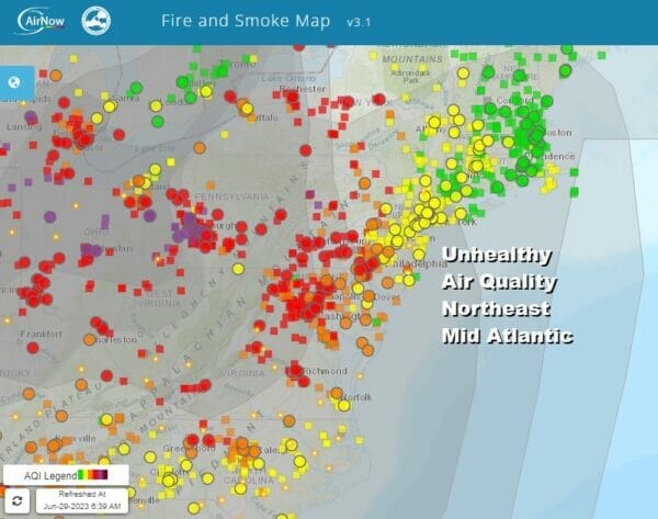
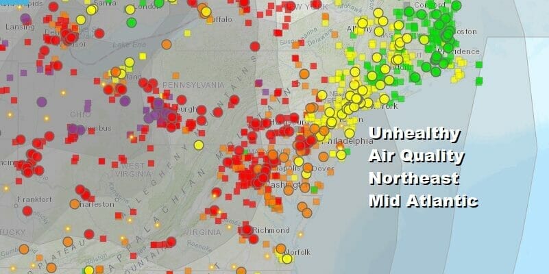
It figures that once we get rid of the seemingly endless risk for thunderstorms, we get back into the smokey haze that has been around for much of June. Wildfire smoke continues to spread to the entire East Coast and the red dots on the Fire.airnow.gov website shows unhealthy conditions from NYC and surrounding areas to Washington DC. You can check the air quailty in your location by clicking on the link or the image. Smoke will continue to be an issue into Friday before it eases somewhat.
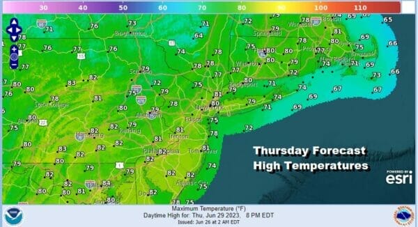
Meanwhile we are getting a break from the humidity and the thunderstorms of the last several days and at least we will see (or perhaps not see) the sun through hazy skies. Dew points will be in the upper 50s to around 60 so it will be much more comfortable than it was the last two days. Also the atmosphere is stable so we do not expect any thunderstorms. Highs this afternoon will be in the upper 70s along the coast and mostly lower 80s inland. The satellite shows us in clear skies but it also picks up the smokey haze. Radars are nice and quiet in Eastern Pennsylvania to Southern New England.
SATELLITE

WEATHER RADAR

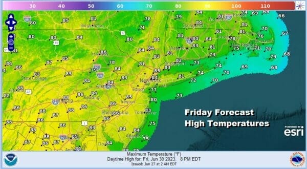
Most lows tonight will be in the upper 50s well inland and low to mid 60s in most other locations in Eastern Pennsylvania to Southern New England. Friday we will hold on to the dry air for one more day before we head into a weekend of changes. Skies should be no worse than partly sunny though again a smokey haze is likely. Highs will be in the low to middle 80s with 70s at the beaches.
The upper air pattern will shift around again Friday night and Saturday and weather systems that are moving out of the Rockies will ripple eastward. Actually there are a series of these systems that will be moving along a west to east flow. As each one goes by it will likely set off some downpours and thunderstorms though it should be emphasized that it will not rain all the time and there will be dry sunny periods in between.

The first chance moves through later Friday night into Saturday morning as a warm front goes by. Then it turns humid again over the weekend. Temperatures may actually be a little bit below average as we will have limited sun and all the hot air is in the South and Southwest where an upper ridge has parked itself for the last week or so. Even in this area that upper high is breaking down so there is no sign of any long duration heatwave settling into the Northeast and Northern Mid Atlantic states.
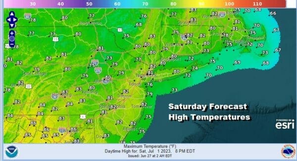
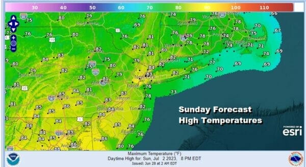
Saturday highs will reach into the lower 80s depending on how much sun breaks out in between the early morning showers, and the late day showers and thunderstorms running around. Once those storms play through we will likely see warm and humid conditions continue Sunday though there should be some sun in the mix before we deal with shower and thunderstorm chances later in the day. Highs will also reach into the 80s. Temperatures both days will be cooler at the shore.
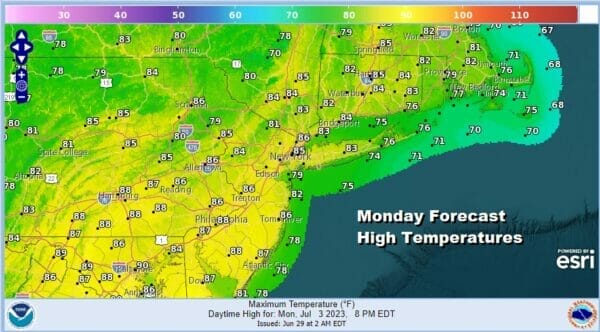
The pattern continues Monday and Tuesday but we will likely see more in the way of sun on both days and this should take temperatures higher and back to average for this time of year. Highs Monday and Tuesday will be in the mid to upper 80s. It will be in the cooler 70s to near 80 at the beaches.
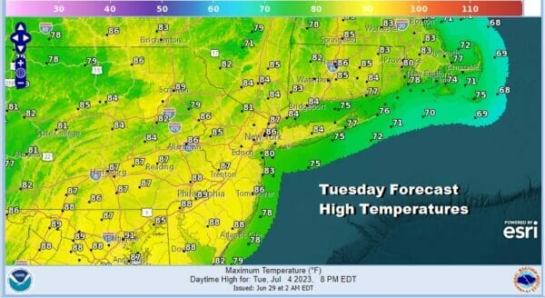
There will be some showers and thunderstorms running around Monday afternoon and Tuesday afternoon but there where and when at this point is too far away in the long range. However I am taking the position that much of the time it should be okay. The one thing that would be problematic is if a front goes by Tuesday and sets up an onshore flow of clouds and some rain. I rate that as a long shot chance at this point and will just go along with a warm humid day with some thunderstorm risk. We will of course update our thoughts on this in the coming days.
BE SURE TO DOWNLOAD THE FREE METEOROLOGIST JOE CIOFFI WEATHER APP &
ANGRY BEN’S FREE WEATHER APP “THE ANGRY WEATHERMAN!
MANY THANKS TO TROPICAL TIDBITS FOR THE USE OF MAPS
Please note that with regards to any severe weather, tropical storms, or hurricanes, should a storm be threatening, please consult your local National Weather Service office or your local government officials about what action you should be taking to protect life and property.
(Amazon is an affilate of Meteorologist Joe Cioffi & earns commissions on sales.)


