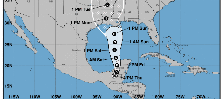
Cristobal Stuck Inland in Mexico Will Move Northward Friday Strengthen Saturday
LOCATION…17.5N 90.8W
ABOUT 165 MI…270 KM S OF CAMPECHE MEXICO
MAXIMUM SUSTAINED WINDS…35 MPH…55 KM/H
PRESENT MOVEMENT…ESE OR 110 DEGREES AT 3 MPH…6 KM/H
MINIMUM CENTRAL PRESSURE…999 MB…29.50 INCHES
Cristobal remains inland in Mexico with the center completely over land however part of the circulation remains over the water. This is producing heavy rains over the Yucatan and in Central America for the third day in a row and they have another day or two of dealing with this before weather conditions improve there. We have also been seeing rain in Florida and Flash Flood Watches are posted for much of Central and Southern Florida. Flash Flood Watches are also posted for the Central Gulf coast and more will go up as we head into the weekend.
SATELLITE
The satellite view this evening shows the center completely over land but we see all that moisture thanks to a large gyre of low pressure in the upper atmosphere that is in control of all this. The Southeast regional radar shows the rain over Florida and in the Gulf of Mexico that continues to feed in from the south and southwest.
SOUTHEAST REGIONAL RADAR
As far as Cristobal is concerned, upper air winds will gradually turn southerly on Friday and this should start a northward drift. Eventually it will result in the low center emerging into the South Central Gulf of Mexico Friday night and Saturday. At this point strengthening will get underway.
There has been hardly any change in the forecast track for the last three days and there is nothing that suggests anything different today. Weather models take Cristobal northward over the weekend and the threat for landfall along the Louisiana coast is increasing. It will likely come ashore as a moderate to strong tropical storm and heavy rains are the biggest issue. 5 to 10 inches of rain is likely from the Central Gulf coast east to covering most of Florida. Some locally higher amounts are possible in some areas. This should move along with little chance for stalling as that would make the rain outcome even worse.
BE SURE TO DOWNLOAD THE FREE METEOROLOGIST JOE CIOFFI WEATHER APP &
ANGRY BEN’S FREE WEATHER APP “THE ANGRY WEATHERMAN!
MANY THANKS TO TROPICAL TIDBITS FOR THE USE OF MAPS
Please note that with regards to any severe weather, tropical storms, or hurricanes, should a storm be threatening, please consult your local National Weather Service office or your local government officials about what action you should be taking to protect life and property.


